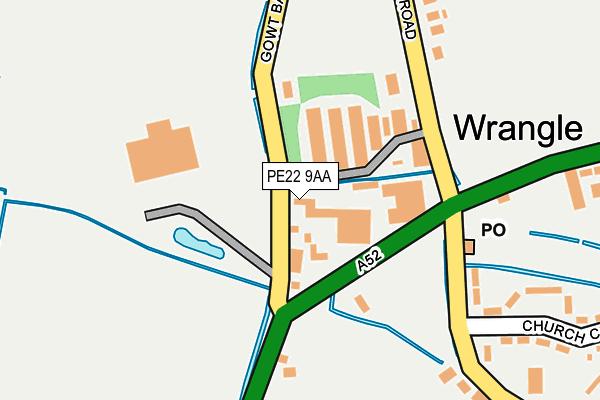
PE22 9AA is located in the Old Leake and Wrangle electoral ward, within the local authority district of Boston and the English Parliamentary constituency of Boston and Skegness. The Sub Integrated Care Board (ICB) Location is NHS Lincolnshire ICB - 71E and the police force is Lincolnshire. This postcode has been in use since January 1980.


GetTheData
Source: OS OpenMap – Local (Ordnance Survey)
Source: OS VectorMap District (Ordnance Survey)
Licence: Open Government Licence (requires attribution)
| Easting | 542202 |
| Northing | 351112 |
| Latitude | 53.038410 |
| Longitude | 0.119437 |
GetTheData
Source: Open Postcode Geo
Licence: Open Government Licence
| Country | England |
| Postcode District | PE22 |
| ➜ PE22 open data dashboard ➜ See where PE22 is on a map ➜ Where is Wrangle? | |
GetTheData
Source: Land Registry Price Paid Data
Licence: Open Government Licence
Elevation or altitude of PE22 9AA as distance above sea level:
| Metres | Feet | |
|---|---|---|
| Elevation | 0m | 0ft |
Elevation is measured from the approximate centre of the postcode, to the nearest point on an OS contour line from OS Terrain 50, which has contour spacing of ten vertical metres.
➜ How high above sea level am I? Find the elevation of your current position using your device's GPS.
GetTheData
Source: Open Postcode Elevation
Licence: Open Government Licence
| Ward | Old Leake And Wrangle |
| Constituency | Boston And Skegness |
GetTheData
Source: ONS Postcode Database
Licence: Open Government Licence
| April 2022 | Violence and sexual offences | On or near Oak Court | 443m |
| April 2022 | Violence and sexual offences | On or near Oak Court | 443m |
| March 2022 | Violence and sexual offences | On or near Oak Court | 443m |
| ➜ Get more crime data in our Crime section | |||
GetTheData
Source: data.police.uk
Licence: Open Government Licence
| Post Office (Church End) | Wrangle | 147m |
| Post Office (Church End) | Wrangle | 163m |
| Angel Inn (Church End) | Wrangle | 306m |
| Angel Inn (Church End) | Wrangle | 320m |
| The Minstrels (A52) | Wrangle | 393m |
GetTheData
Source: NaPTAN
Licence: Open Government Licence
GetTheData
Source: ONS Postcode Database
Licence: Open Government Licence


➜ Get more ratings from the Food Standards Agency
GetTheData
Source: Food Standards Agency
Licence: FSA terms & conditions
| Last Collection | |||
|---|---|---|---|
| Location | Mon-Fri | Sat | Distance |
| Wrangle Post Office | 16:30 | 11:00 | 163m |
| Four Cross Roads | 16:15 | 08:30 | 1,071m |
| Old Leake Post Office | 17:00 | 10:45 | 1,606m |
GetTheData
Source: Dracos
Licence: Creative Commons Attribution-ShareAlike
| Facility | Distance |
|---|---|
| Wrangle Parish Hall Church End, Church End, Wrangle, Boston Sports Hall | 302m |
| Wrangle Playing Field Main Road, Wrangle, Boston Grass Pitches | 483m |
| The Giles Academy Church End, Old Leake, Boston Sports Hall, Grass Pitches, Swimming Pool | 1.7km |
GetTheData
Source: Active Places
Licence: Open Government Licence
| School | Phase of Education | Distance |
|---|---|---|
| Wrangle Primary School Main Road, Wrangle, Boston, PE22 9AS | Primary | 1.3km |
| Old Leake Primary Academy Old Main Road, Old Leake, Boston, PE22 9HR | Primary | 1.5km |
| The Giles Academy Church Lane, Old Leake, Boston, PE22 9LD | Secondary | 1.7km |
GetTheData
Source: Edubase
Licence: Open Government Licence
| Risk of PE22 9AA flooding from rivers and sea | Low |
| ➜ PE22 9AA flood map | |
GetTheData
Source: Open Flood Risk by Postcode
Licence: Open Government Licence
The below table lists the International Territorial Level (ITL) codes (formerly Nomenclature of Territorial Units for Statistics (NUTS) codes) and Local Administrative Units (LAU) codes for PE22 9AA:
| ITL 1 Code | Name |
|---|---|
| TLF | East Midlands (England) |
| ITL 2 Code | Name |
| TLF3 | Lincolnshire |
| ITL 3 Code | Name |
| TLF30 | Lincolnshire CC |
| LAU 1 Code | Name |
| E07000136 | Boston |
GetTheData
Source: ONS Postcode Directory
Licence: Open Government Licence
The below table lists the Census Output Area (OA), Lower Layer Super Output Area (LSOA), and Middle Layer Super Output Area (MSOA) for PE22 9AA:
| Code | Name | |
|---|---|---|
| OA | E00132060 | |
| LSOA | E01026023 | Boston 001D |
| MSOA | E02005417 | Boston 001 |
GetTheData
Source: ONS Postcode Directory
Licence: Open Government Licence
| PE22 9BZ | Gowt Bank | 0m |
| PE22 9AD | Main Road | 115m |
| PE22 9BY | Common Road | 268m |
| PE22 9EL | Church Close | 321m |
| PE22 9EW | Church End | 325m |
| PE22 9DB | Lockhamgate | 332m |
| PE22 9AL | Mel Marshall Way | 382m |
| PE22 9DD | Lockhamgate | 485m |
| PE22 9AJ | Main Road | 549m |
| PE22 9AF | Main Road | 563m |
GetTheData
Source: Open Postcode Geo; Land Registry Price Paid Data
Licence: Open Government Licence