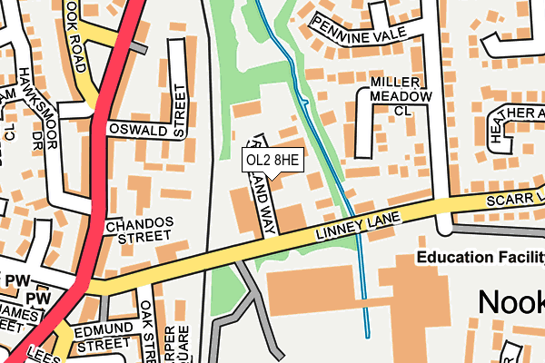
OL2 8HE is located in the Shaw electoral ward, within the metropolitan district of Oldham and the English Parliamentary constituency of Oldham East and Saddleworth. The Sub Integrated Care Board (ICB) Location is NHS Greater Manchester ICB - 00Y and the police force is Greater Manchester. This postcode has been in use since January 1980.


GetTheData
Source: OS OpenMap – Local (Ordnance Survey)
Source: OS VectorMap District (Ordnance Survey)
Licence: Open Government Licence (requires attribution)
| Easting | 394264 |
| Northing | 409489 |
| Latitude | 53.581960 |
| Longitude | -2.088110 |
GetTheData
Source: Open Postcode Geo
Licence: Open Government Licence
| Country | England |
| Postcode District | OL2 |
| ➜ OL2 open data dashboard ➜ See where OL2 is on a map ➜ Where is Shaw? | |
GetTheData
Source: Land Registry Price Paid Data
Licence: Open Government Licence
Elevation or altitude of OL2 8HE as distance above sea level:
| Metres | Feet | |
|---|---|---|
| Elevation | 180m | 591ft |
Elevation is measured from the approximate centre of the postcode, to the nearest point on an OS contour line from OS Terrain 50, which has contour spacing of ten vertical metres.
➜ How high above sea level am I? Find the elevation of your current position using your device's GPS.
GetTheData
Source: Open Postcode Elevation
Licence: Open Government Licence
| Ward | Shaw |
| Constituency | Oldham East And Saddleworth |
GetTheData
Source: ONS Postcode Database
Licence: Open Government Licence
| April 2022 | Other crime | On or near Helmshore Way | 378m |
| November 2021 | Other theft | On or near Gilderdale Close | 353m |
| October 2021 | Violence and sexual offences | On or near Cunliffe Drive | 344m |
| ➜ Get more crime data in our Crime section | |||
GetTheData
Source: data.police.uk
Licence: Open Government Licence
| Linney Ln/Rutland Way (Linney Ln) | Buckstones Estate | 80m |
| Linney Ln/George St (Linney Ln) | Buckstones Estate | 118m |
| George St/Scarr Ln (George St) | Buckstones Estate | 181m |
| Oak St/Linney Ln (Oak St) | Shaw | 190m |
| George St/Scarr Ln (George St) | Buckstones Estate | 191m |
| Shaw And Crompton (Manchester Metrolink) (Beal Lane) | Shaw | 654m |
| Rochdale Station | 5.4km |
| Greenfield Station | 6.9km |
GetTheData
Source: NaPTAN
Licence: Open Government Licence
GetTheData
Source: ONS Postcode Database
Licence: Open Government Licence


➜ Get more ratings from the Food Standards Agency
GetTheData
Source: Food Standards Agency
Licence: FSA terms & conditions
| Last Collection | |||
|---|---|---|---|
| Location | Mon-Fri | Sat | Distance |
| Wrens Nest | 17:15 | 11:45 | 220m |
| Beal Lane | 17:30 | 12:00 | 578m |
| 48 Salt Street | 17:00 | 11:45 | 590m |
GetTheData
Source: Dracos
Licence: Creative Commons Attribution-ShareAlike
| Facility | Distance |
|---|---|
| George Street Playing Fields George Street, Shaw, Oldham Grass Pitches | 345m |
| Elite Fitness Grains Road, Shaw, Oldham Sports Hall, Health and Fitness Gym, Studio | 419m |
| Dunwood Park Smallbrook Road, Shaw, Oldham Outdoor Tennis Courts | 567m |
GetTheData
Source: Active Places
Licence: Open Government Licence
| School | Phase of Education | Distance |
|---|---|---|
| East Crompton St George's CofE School George Street, Shaw, Oldham, OL2 8AX | Primary | 353m |
| East Crompton St James CofE Primary School St James Street, Shaw, Oldham, OL2 7TD | Primary | 409m |
| Buckstones Primary School Delamere Avenue, Shaw, Oldham, OL2 8HN | Primary | 433m |
GetTheData
Source: Edubase
Licence: Open Government Licence
| Risk of OL2 8HE flooding from rivers and sea | Very Low |
| ➜ OL2 8HE flood map | |
GetTheData
Source: Open Flood Risk by Postcode
Licence: Open Government Licence
The below table lists the International Territorial Level (ITL) codes (formerly Nomenclature of Territorial Units for Statistics (NUTS) codes) and Local Administrative Units (LAU) codes for OL2 8HE:
| ITL 1 Code | Name |
|---|---|
| TLD | North West (England) |
| ITL 2 Code | Name |
| TLD3 | Greater Manchester |
| ITL 3 Code | Name |
| TLD37 | Greater Manchester North East |
| LAU 1 Code | Name |
| E08000004 | Oldham |
GetTheData
Source: ONS Postcode Directory
Licence: Open Government Licence
The below table lists the Census Output Area (OA), Lower Layer Super Output Area (LSOA), and Middle Layer Super Output Area (MSOA) for OL2 8HE:
| Code | Name | |
|---|---|---|
| OA | E00027568 | |
| LSOA | E01005445 | Oldham 002D |
| MSOA | E02001099 | Oldham 002 |
GetTheData
Source: ONS Postcode Directory
Licence: Open Government Licence
| OL2 8HB | Linney Lane | 46m |
| OL2 8BB | Oswald Street | 115m |
| OL2 8DU | Ballard Way | 127m |
| OL2 8DT | Miller Meadow Close | 144m |
| OL2 8BA | Oswald Street | 153m |
| OL2 8AY | Milnrow Road | 176m |
| OL2 8DJ | George Street | 196m |
| OL2 8BE | Milnrow Road | 197m |
| OL2 8DH | Pennine Vale | 200m |
| OL2 7TN | Milnrow Road | 204m |
GetTheData
Source: Open Postcode Geo; Land Registry Price Paid Data
Licence: Open Government Licence