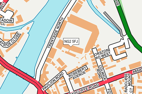
NG2 5FJ is located in the Trent Bridge electoral ward, within the local authority district of Rushcliffe and the English Parliamentary constituency of Rushcliffe. The Sub Integrated Care Board (ICB) Location is NHS Nottingham and Nottinghamshire ICB - 52R and the police force is Nottinghamshire. This postcode has been in use since January 1980.


GetTheData
Source: OS OpenMap – Local (Ordnance Survey)
Source: OS VectorMap District (Ordnance Survey)
Licence: Open Government Licence (requires attribution)
| Easting | 458351 |
| Northing | 338357 |
| Latitude | 52.939444 |
| Longitude | -1.133199 |
GetTheData
Source: Open Postcode Geo
Licence: Open Government Licence
| Country | England |
| Postcode District | NG2 |
| ➜ NG2 open data dashboard ➜ See where NG2 is on a map ➜ Where is West Bridgford? | |
GetTheData
Source: Land Registry Price Paid Data
Licence: Open Government Licence
Elevation or altitude of NG2 5FJ as distance above sea level:
| Metres | Feet | |
|---|---|---|
| Elevation | 30m | 98ft |
Elevation is measured from the approximate centre of the postcode, to the nearest point on an OS contour line from OS Terrain 50, which has contour spacing of ten vertical metres.
➜ How high above sea level am I? Find the elevation of your current position using your device's GPS.
GetTheData
Source: Open Postcode Elevation
Licence: Open Government Licence
| Ward | Trent Bridge |
| Constituency | Rushcliffe |
GetTheData
Source: ONS Postcode Database
Licence: Open Government Licence
| June 2022 | Bicycle theft | On or near Rosebery Avenue | 109m |
| June 2022 | Bicycle theft | On or near Pavilion Road | 150m |
| June 2022 | Bicycle theft | On or near Pavilion Road | 150m |
| ➜ Get more crime data in our Crime section | |||
GetTheData
Source: data.police.uk
Licence: Open Government Licence
| Fox Road (Radcliffe Road) | Trent Bridge | 202m |
| Cricket Ground (Radcliffe Road) | Trent Bridge | 207m |
| Fox Road (Radcliffe Road) | Trent Bridge | 209m |
| Victoria Embankment (Trent Bridge) | Trent Bridge | 317m |
| Cricket Ground (Bridgford Road) | Trent Bridge | 330m |
| Nottingham Station Tram Stop (N/A) | Nottingham | 1,175m |
| Queens Walk Tram Stop (Queens Walk) | Meadows | 1,213m |
| Meadows Embankment Tram Stop (Queens Walk) | Meadows | 1,377m |
| Old Market Square Tram Stop (South Parade) | Nottingham | 1,917m |
| Nottingham Station | 1.2km |
| Netherfield Station | 4.3km |
| Carlton Station | 4.6km |
GetTheData
Source: NaPTAN
Licence: Open Government Licence
GetTheData
Source: ONS Postcode Database
Licence: Open Government Licence


➜ Get more ratings from the Food Standards Agency
GetTheData
Source: Food Standards Agency
Licence: FSA terms & conditions
| Last Collection | |||
|---|---|---|---|
| Location | Mon-Fri | Sat | Distance |
| Radcliffe Road | 17:00 | 12:00 | 214m |
| War Memorial | 18:30 | 12:30 | 404m |
| Bridgford Road | 404m | ||
GetTheData
Source: Dracos
Licence: Creative Commons Attribution-ShareAlike
| Facility | Distance |
|---|---|
| Nottingham Forest Fc (The City Ground) Pavilion Road, West Bridgford, Nottingham Grass Pitches | 0m |
| The Bay Sports Ground Holme Road, West Bridgford Grass Pitches, Artificial Grass Pitch, Outdoor Tennis Courts | 332m |
| Trent Bridge Cricket Ground (Nottinghamshire Ccc) Bridgford Road, West Bridgford, Nottingham Health and Fitness Gym, Grass Pitches, Squash Courts | 397m |
GetTheData
Source: Active Places
Licence: Open Government Licence
| School | Phase of Education | Distance |
|---|---|---|
| Clayfield House Care of: Nottinghamshire County Council, County Hall, Loughborough Road, Nottingham, NG2 7QP | Not applicable | 367m |
| Greenfields Community School Orange Gardens, The Meadows, Nottingham, NG2 2JE | Primary | 693m |
| Lady Bay Primary School Trent Boulevard, West Bridgford, Nottingham, NG2 5BD | Primary | 770m |
GetTheData
Source: Edubase
Licence: Open Government Licence
| Risk of NG2 5FJ flooding from rivers and sea | Low |
| ➜ NG2 5FJ flood map | |
GetTheData
Source: Open Flood Risk by Postcode
Licence: Open Government Licence
The below table lists the International Territorial Level (ITL) codes (formerly Nomenclature of Territorial Units for Statistics (NUTS) codes) and Local Administrative Units (LAU) codes for NG2 5FJ:
| ITL 1 Code | Name |
|---|---|
| TLF | East Midlands (England) |
| ITL 2 Code | Name |
| TLF1 | Derbyshire and Nottinghamshire |
| ITL 3 Code | Name |
| TLF16 | South Nottinghamshire |
| LAU 1 Code | Name |
| E07000176 | Rushcliffe |
GetTheData
Source: ONS Postcode Directory
Licence: Open Government Licence
The below table lists the Census Output Area (OA), Lower Layer Super Output Area (LSOA), and Middle Layer Super Output Area (MSOA) for NG2 5FJ:
| Code | Name | |
|---|---|---|
| OA | E00144807 | |
| LSOA | E01028416 | Rushcliffe 005D |
| MSOA | E02005910 | Rushcliffe 005 |
GetTheData
Source: ONS Postcode Directory
Licence: Open Government Licence
| NG2 5FQ | Rosebery Avenue | 95m |
| NG2 5FR | Colwick Road | 142m |
| NG2 5FG | Pavilion Road | 148m |
| NG2 5FF | Radcliffe Road | 155m |
| NG2 5FT | Thoroton Road | 192m |
| NG2 3HR | Meadow Lane | 200m |
| NG2 5FU | Orston Road | 210m |
| NG2 5FS | Hawksworth Road | 220m |
| NG2 6AL | Fox Road | 252m |
| NG2 3BP | Quayside Close | 264m |
GetTheData
Source: Open Postcode Geo; Land Registry Price Paid Data
Licence: Open Government Licence