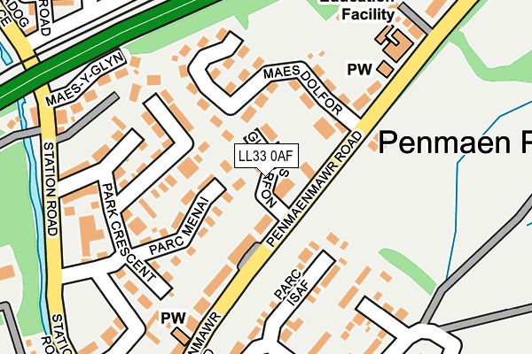
LL33 0AF is located in the Bryn electoral ward, within the unitary authority of Conwy and the Welsh Parliamentary constituency of Aberconwy. The Local Health Board is Betsi Cadwaladr University and the police force is North Wales. This postcode has been in use since February 2017.


GetTheData
Source: OS OpenMap – Local (Ordnance Survey)
Source: OS VectorMap District (Ordnance Survey)
Licence: Open Government Licence (requires attribution)
| Easting | 268264 |
| Northing | 375159 |
| Latitude | 53.257050 |
| Longitude | -3.976239 |
GetTheData
Source: Open Postcode Geo
Licence: Open Government Licence
| Country | Wales |
| Postcode District | LL33 |
➜ See where LL33 is on a map ➜ Where is Llanfairfechan? | |
GetTheData
Source: Land Registry Price Paid Data
Licence: Open Government Licence
| Ward | Bryn |
| Constituency | Aberconwy |
GetTheData
Source: ONS Postcode Database
Licence: Open Government Licence
| Plas Menai (Penmaenmawr Road) | Llanfairfechan | 60m |
| Plas Menai (Penmaenmawr Road) | Llanfairfechan | 108m |
| Plas Y Berth (Penmaenmawr Road) | Llanfairfechan | 244m |
| Plas Y Berth (Penmaenmawr Road) | Llanfairfechan | 253m |
| Penmaen Park (Penmaenmawr Road) | Llanfairfechan | 291m |
| Llanfairfechan Station | 0.5km |
| Penmaenmawr Station | 3.8km |
GetTheData
Source: NaPTAN
Licence: Open Government Licence
| Percentage of properties with Next Generation Access | 100.0% |
| Percentage of properties with Superfast Broadband | 85.7% |
| Percentage of properties with Ultrafast Broadband | 0.0% |
| Percentage of properties with Full Fibre Broadband | 0.0% |
Superfast Broadband is between 30Mbps and 300Mbps
Ultrafast Broadband is > 300Mbps
| Median download speed | 40.0Mbps |
| Average download speed | 44.4Mbps |
| Maximum download speed | 80.00Mbps |
| Median upload speed | 10.0Mbps |
| Average upload speed | 10.9Mbps |
| Maximum upload speed | 20.00Mbps |
| Percentage of properties unable to receive 2Mbps | 0.0% |
| Percentage of properties unable to receive 5Mbps | 0.0% |
| Percentage of properties unable to receive 10Mbps | 0.0% |
| Percentage of properties unable to receive 30Mbps | 14.3% |
GetTheData
Source: Ofcom
Licence: Ofcom Terms of Use (requires attribution)
GetTheData
Source: ONS Postcode Database
Licence: Open Government Licence


➜ Get more ratings from the Food Standards Agency
GetTheData
Source: Food Standards Agency
Licence: FSA terms & conditions
| Last Collection | |||
|---|---|---|---|
| Location | Mon-Fri | Sat | Distance |
| Station Road | 16:55 | 10:30 | 317m |
GetTheData
Source: Dracos
Licence: Creative Commons Attribution-ShareAlike
The below table lists the International Territorial Level (ITL) codes (formerly Nomenclature of Territorial Units for Statistics (NUTS) codes) and Local Administrative Units (LAU) codes for LL33 0AF:
| ITL 1 Code | Name |
|---|---|
| TLL | Wales |
| ITL 2 Code | Name |
| TLL1 | West Wales and The Valleys |
| ITL 3 Code | Name |
| TLL13 | Conwy and Denbighshire |
| LAU 1 Code | Name |
| W06000003 | Conwy |
GetTheData
Source: ONS Postcode Directory
Licence: Open Government Licence
The below table lists the Census Output Area (OA), Lower Layer Super Output Area (LSOA), and Middle Layer Super Output Area (MSOA) for LL33 0AF:
| Code | Name | |
|---|---|---|
| OA | W00000649 | |
| LSOA | W01000123 | Conwy 013A |
| MSOA | W02000039 | Conwy 013 |
GetTheData
Source: ONS Postcode Directory
Licence: Open Government Licence
| LL33 0BA | Park Crescent | 100m |
| LL33 0AY | Parc Menai | 104m |
| LL33 0RP | Maes Dolfor | 104m |
| LL33 0PA | Penmaenmawr Road | 105m |
| LL33 0NY | Penmaenmawr Road | 120m |
| LL33 0BB | Garth Wen | 127m |
| LL33 0AU | Park Crescent | 157m |
| LL33 0AH | Parc Isaf | 160m |
| LL33 0BH | Park Crescent | 163m |
| LL33 0GB | Park Crescent North | 165m |
GetTheData
Source: Open Postcode Geo; Land Registry Price Paid Data
Licence: Open Government Licence