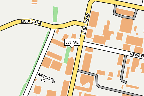
L33 7AE is located in the Northwood electoral ward, within the metropolitan district of Knowsley and the English Parliamentary constituency of Knowsley. The Sub Integrated Care Board (ICB) Location is NHS Cheshire and Merseyside ICB - 01J and the police force is Merseyside. This postcode has been in use since March 2017.


GetTheData
Source: OS OpenMap – Local (Ordnance Survey)
Source: OS VectorMap District (Ordnance Survey)
Licence: Open Government Licence (requires attribution)
| Easting | 344053 |
| Northing | 399322 |
| Latitude | 53.487637 |
| Longitude | -2.844639 |
GetTheData
Source: Open Postcode Geo
Licence: Open Government Licence
| Country | England |
| Postcode District | L33 |
| ➜ L33 open data dashboard ➜ See where L33 is on a map ➜ Where is Kirkby? | |
GetTheData
Source: Land Registry Price Paid Data
Licence: Open Government Licence
| Ward | Northwood |
| Constituency | Knowsley |
GetTheData
Source: ONS Postcode Database
Licence: Open Government Licence
| May 2022 | Vehicle crime | On or near Moss End Way | 205m |
| April 2022 | Burglary | On or near Moss End Way | 205m |
| March 2022 | Bicycle theft | On or near Moss End Way | 205m |
| ➜ Get more crime data in our Crime section | |||
GetTheData
Source: data.police.uk
Licence: Open Government Licence
| Moss End Way (Acornfield Road) | Knowsley Industrial Park | 228m |
| Ashcroft Road (Acornfield Road) | Knowsley Industrial Park | 395m |
| Ashcroft Road (Hammond Road) | Knowsley Industrial Park | 654m |
| Acornfield Road | Knowsley Industrial Park | 660m |
| Newsett Road (Birchill Road) | Knowsley Industrial Park | 834m |
| Kirkby Station | 3.9km |
| Rainford Station | 4.9km |
GetTheData
Source: NaPTAN
Licence: Open Government Licence
GetTheData
Source: ONS Postcode Database
Licence: Open Government Licence


➜ Get more ratings from the Food Standards Agency
GetTheData
Source: Food Standards Agency
Licence: FSA terms & conditions
| Last Collection | |||
|---|---|---|---|
| Location | Mon-Fri | Sat | Distance |
| Saxon Way/Washington Drive | 17:00 | 12:00 | 1,512m |
| Kirkby Post Office | 18:00 | 12:00 | 2,850m |
| Barrow Nook | 16:15 | 10:30 | 3,218m |
GetTheData
Source: Dracos
Licence: Creative Commons Attribution-ShareAlike
| Facility | Distance |
|---|---|
| Liverpool Fc (Axa Training Centre) Arbour Lane, Liverpool Grass Pitches | 1.4km |
| Eddie Mcardle Memorial Playing Fields Simonswood Lane, Northwood, Kirkby Grass Pitches | 1.5km |
| Muscle Health And Fitness (Closed) Gale Road, Knowsley Industrial Park, Liverpool Health and Fitness Gym, Sports Hall | 1.6km |
GetTheData
Source: Active Places
Licence: Open Government Licence
| School | Phase of Education | Distance |
|---|---|---|
| St Marie's Catholic Primary School Bigdale Drive, Northwood, Kirkby, Liverpool, L33 6XL | Primary | 1.9km |
| Eastcroft Park School Hollinghurst Road, Tower Hill, Kirkby, Liverpool, L33 1EB | Primary | 2.4km |
| Northwood Community Primary School (With Designated Special Provision) Roughwood Drive, Northwood, Kirkby, L33 8XD | Primary | 2.4km |
GetTheData
Source: Edubase
Licence: Open Government Licence
The below table lists the International Territorial Level (ITL) codes (formerly Nomenclature of Territorial Units for Statistics (NUTS) codes) and Local Administrative Units (LAU) codes for L33 7AE:
| ITL 1 Code | Name |
|---|---|
| TLD | North West (England) |
| ITL 2 Code | Name |
| TLD7 | Merseyside |
| ITL 3 Code | Name |
| TLD71 | East Merseyside |
| LAU 1 Code | Name |
| E08000011 | Knowsley |
GetTheData
Source: ONS Postcode Directory
Licence: Open Government Licence
The below table lists the Census Output Area (OA), Lower Layer Super Output Area (LSOA), and Middle Layer Super Output Area (MSOA) for L33 7AE:
| Code | Name | |
|---|---|---|
| OA | E00032676 | |
| LSOA | E01006448 | Knowsley 001A |
| MSOA | E02001327 | Knowsley 001 |
GetTheData
Source: ONS Postcode Directory
Licence: Open Government Licence
| L33 7UZ | Woodward Road | 361m |
| L33 7UR | Bradman Road | 478m |
| L33 7UH | Marl Road | 808m |
| L33 7TJ | Newstet Road | 949m |
| L33 7SY | Kirkby Bank Road | 1068m |
| L33 3AT | Dale Lane | 1205m |
| L33 7RW | Lees Road | 1215m |
| L33 7SQ | Webber Road | 1295m |
| L33 7XE | Arbour Court | 1339m |
| L33 7SW | Webber Road | 1373m |
GetTheData
Source: Open Postcode Geo; Land Registry Price Paid Data
Licence: Open Government Licence