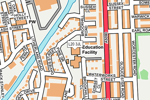
L20 3JL is located in the Derby electoral ward, within the metropolitan district of Sefton and the English Parliamentary constituency of Bootle. The Sub Integrated Care Board (ICB) Location is NHS Cheshire and Merseyside ICB - 01T and the police force is Merseyside. This postcode has been in use since January 1980.


GetTheData
Source: OS OpenMap – Local (Ordnance Survey)
Source: OS VectorMap District (Ordnance Survey)
Licence: Open Government Licence (requires attribution)
| Easting | 334657 |
| Northing | 395584 |
| Latitude | 53.452943 |
| Longitude | -2.985445 |
GetTheData
Source: Open Postcode Geo
Licence: Open Government Licence
| Country | England |
| Postcode District | L20 |
| ➜ L20 open data dashboard ➜ See where L20 is on a map ➜ Where is Bootle? | |
GetTheData
Source: Land Registry Price Paid Data
Licence: Open Government Licence
Elevation or altitude of L20 3JL as distance above sea level:
| Metres | Feet | |
|---|---|---|
| Elevation | 20m | 66ft |
Elevation is measured from the approximate centre of the postcode, to the nearest point on an OS contour line from OS Terrain 50, which has contour spacing of ten vertical metres.
➜ How high above sea level am I? Find the elevation of your current position using your device's GPS.
GetTheData
Source: Open Postcode Elevation
Licence: Open Government Licence
| Ward | Derby |
| Constituency | Bootle |
GetTheData
Source: ONS Postcode Database
Licence: Open Government Licence
| June 2022 | Violence and sexual offences | On or near Brookhill Road | 89m |
| June 2022 | Violence and sexual offences | On or near Sports/Recreation Area | 124m |
| June 2022 | Violence and sexual offences | On or near Sports/Recreation Area | 124m |
| ➜ Get more crime data in our Crime section | |||
GetTheData
Source: data.police.uk
Licence: Open Government Licence
| Earl Road (Hawthorne Road) | Bootle | 170m |
| Derby Park (Worcester Road) | Bootle | 230m |
| Earl Road (Worcester Road) | Bootle | 239m |
| Mill Lane (Hawthorne Road) | Bootle | 255m |
| Well Lane (Park Street) | Bootle | 298m |
| Bootle New Strand Station | 0.6km |
| Bootle Oriel Road Station | 1km |
| Walton (Merseyside) Station | 1.4km |
GetTheData
Source: NaPTAN
Licence: Open Government Licence
GetTheData
Source: ONS Postcode Database
Licence: Open Government Licence


➜ Get more ratings from the Food Standards Agency
GetTheData
Source: Food Standards Agency
Licence: FSA terms & conditions
| Last Collection | |||
|---|---|---|---|
| Location | Mon-Fri | Sat | Distance |
| Litherland Road | 17:15 | 12:00 | 158m |
| Hawthorne Road | 17:00 | 12:00 | 190m |
| Bootle New Strand Post Office | 18:00 | 12:00 | 445m |
GetTheData
Source: Dracos
Licence: Creative Commons Attribution-ShareAlike
| Facility | Distance |
|---|---|
| The Inclusive Hub Thornton Road, Bootle, Liverpool Sports Hall | 508m |
| Bootle Leisure Centre Washington Parade, Bootle Sports Hall, Swimming Pool, Health and Fitness Gym, Studio | 688m |
| Bootle Stadium Sports Centre (Closed) Maguire Avenue, Bootle Sports Hall, Studio, Health and Fitness Gym, Squash Courts | 745m |
GetTheData
Source: Active Places
Licence: Open Government Licence
| School | Phase of Education | Distance |
|---|---|---|
| Christ Church Church of England Controlled Primary School Brookhill Road, Waterworks Street, Bootle, L20 3JL | Primary | 0m |
| St Monica's Catholic Primary School Kelly Drive, Bootle, L20 9EB | Primary | 737m |
| Bedford Primary School Quarry Road, Bootle, Liverpool, L20 9LJ | Primary | 738m |
GetTheData
Source: Edubase
Licence: Open Government Licence
The below table lists the International Territorial Level (ITL) codes (formerly Nomenclature of Territorial Units for Statistics (NUTS) codes) and Local Administrative Units (LAU) codes for L20 3JL:
| ITL 1 Code | Name |
|---|---|
| TLD | North West (England) |
| ITL 2 Code | Name |
| TLD7 | Merseyside |
| ITL 3 Code | Name |
| TLD73 | Sefton |
| LAU 1 Code | Name |
| E08000014 | Sefton |
GetTheData
Source: ONS Postcode Directory
Licence: Open Government Licence
The below table lists the Census Output Area (OA), Lower Layer Super Output Area (LSOA), and Middle Layer Super Output Area (MSOA) for L20 3JL:
| Code | Name | |
|---|---|---|
| OA | E00035302 | |
| LSOA | E01006966 | Sefton 038F |
| MSOA | E02001466 | Sefton 038 |
GetTheData
Source: ONS Postcode Directory
Licence: Open Government Licence
| L20 3UB | Pine Grove | 71m |
| L20 3AD | Cornwall Road | 80m |
| L20 3NU | Kent Close | 91m |
| L20 3JH | Brookhill Road | 105m |
| L20 3JN | Corporation Wharf | 106m |
| L20 3NY | Waterworks Street | 130m |
| L20 9AX | Hawthorne Road | 141m |
| L20 3NX | Essex Way | 146m |
| L20 3NZ | Brookhill Close | 157m |
| L20 3BU | Well Lane Gardens | 168m |
GetTheData
Source: Open Postcode Geo; Land Registry Price Paid Data
Licence: Open Government Licence