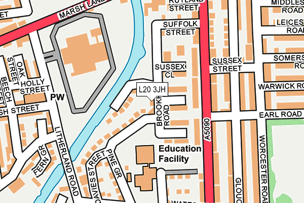
L20 3JH lies on Brookhill Road in Bootle. L20 3JH is located in the Derby electoral ward, within the metropolitan district of Sefton and the English Parliamentary constituency of Bootle. The Sub Integrated Care Board (ICB) Location is NHS Cheshire and Merseyside ICB - 01T and the police force is Merseyside. This postcode has been in use since August 2011.


GetTheData
Source: OS OpenMap – Local (Ordnance Survey)
Source: OS VectorMap District (Ordnance Survey)
Licence: Open Government Licence (requires attribution)
| Easting | 334673 |
| Northing | 395688 |
| Latitude | 53.453879 |
| Longitude | -2.985226 |
GetTheData
Source: Open Postcode Geo
Licence: Open Government Licence
| Street | Brookhill Road |
| Town/City | Bootle |
| Country | England |
| Postcode District | L20 |
➜ See where L20 is on a map ➜ Where is Bootle? | |
GetTheData
Source: Land Registry Price Paid Data
Licence: Open Government Licence
Elevation or altitude of L20 3JH as distance above sea level:
| Metres | Feet | |
|---|---|---|
| Elevation | 20m | 66ft |
Elevation is measured from the approximate centre of the postcode, to the nearest point on an OS contour line from OS Terrain 50, which has contour spacing of ten vertical metres.
➜ How high above sea level am I? Find the elevation of your current position using your device's GPS.
GetTheData
Source: Open Postcode Elevation
Licence: Open Government Licence
| Ward | Derby |
| Constituency | Bootle |
GetTheData
Source: ONS Postcode Database
Licence: Open Government Licence
9, BROOKHILL ROAD, BOOTLE, L20 3JH 2019 24 JUN £140,000 |
GetTheData
Source: HM Land Registry Price Paid Data
Licence: Contains HM Land Registry data © Crown copyright and database right 2025. This data is licensed under the Open Government Licence v3.0.
| Earl Road (Hawthorne Road) | Bootle | 110m |
| Earl Road (Worcester Road) | Bootle | 232m |
| Derby Park (Worcester Road) | Bootle | 246m |
| Hawthorne Road (Marsh Lane) | Bootle | 258m |
| Gloucester Road (Aintree Road) | Bootle | 304m |
| Bootle New Strand Station | 0.6km |
| Bootle Oriel Road Station | 1.1km |
| Walton (Merseyside) Station | 1.3km |
GetTheData
Source: NaPTAN
Licence: Open Government Licence
| Percentage of properties with Next Generation Access | 100.0% |
| Percentage of properties with Superfast Broadband | 100.0% |
| Percentage of properties with Ultrafast Broadband | 100.0% |
| Percentage of properties with Full Fibre Broadband | 0.0% |
Superfast Broadband is between 30Mbps and 300Mbps
Ultrafast Broadband is > 300Mbps
| Median download speed | 9.7Mbps |
| Average download speed | 34.7Mbps |
| Maximum download speed | 100.00Mbps |
| Median upload speed | 0.8Mbps |
| Average upload speed | 0.9Mbps |
| Maximum upload speed | 1.03Mbps |
| Percentage of properties unable to receive 2Mbps | 0.0% |
| Percentage of properties unable to receive 5Mbps | 0.0% |
| Percentage of properties unable to receive 10Mbps | 0.0% |
| Percentage of properties unable to receive 30Mbps | 0.0% |
GetTheData
Source: Ofcom
Licence: Ofcom Terms of Use (requires attribution)
GetTheData
Source: ONS Postcode Database
Licence: Open Government Licence


➜ Get more ratings from the Food Standards Agency
GetTheData
Source: Food Standards Agency
Licence: FSA terms & conditions
| Last Collection | |||
|---|---|---|---|
| Location | Mon-Fri | Sat | Distance |
| Hawthorne Road | 17:00 | 12:00 | 122m |
| Litherland Road | 17:15 | 12:00 | 254m |
| Bootle New Strand Post Office | 18:00 | 12:00 | 520m |
GetTheData
Source: Dracos
Licence: Creative Commons Attribution-ShareAlike
The below table lists the International Territorial Level (ITL) codes (formerly Nomenclature of Territorial Units for Statistics (NUTS) codes) and Local Administrative Units (LAU) codes for L20 3JH:
| ITL 1 Code | Name |
|---|---|
| TLD | North West (England) |
| ITL 2 Code | Name |
| TLD7 | Merseyside |
| ITL 3 Code | Name |
| TLD73 | Sefton |
| LAU 1 Code | Name |
| E08000014 | Sefton |
GetTheData
Source: ONS Postcode Directory
Licence: Open Government Licence
The below table lists the Census Output Area (OA), Lower Layer Super Output Area (LSOA), and Middle Layer Super Output Area (MSOA) for L20 3JH:
| Code | Name | |
|---|---|---|
| OA | E00035302 | |
| LSOA | E01006966 | Sefton 038F |
| MSOA | E02001466 | Sefton 038 |
GetTheData
Source: ONS Postcode Directory
Licence: Open Government Licence
| L20 3JN | Corporation Wharf | 50m |
| L20 3NU | Kent Close | 63m |
| L20 3NX | Essex Way | 87m |
| L20 3UB | Pine Grove | 92m |
| L20 3NS | Sussex Close | 117m |
| L20 9AY | Hawthorne Road | 123m |
| L20 3NP | Suffolk Street | 145m |
| L20 3AD | Cornwall Road | 157m |
| L20 9AX | Hawthorne Road | 173m |
| L20 9AL | Gloucester Road | 188m |
GetTheData
Source: Open Postcode Geo; Land Registry Price Paid Data
Licence: Open Government Licence