
CW7 9GU maps, stats, and open data
CW7 9GU is located in the Winsford Over & Verdin electoral ward, within the unitary authority of Cheshire West and Chester and the English Parliamentary constituency of Eddisbury. The Sub Integrated Care Board (ICB) Location is NHS Cheshire and Merseyside ICB - 27D and the police force is Cheshire. This postcode has been in use since September 2017.
CW7 9GU maps


Licence: Open Government Licence (requires attribution)
Attribution: Contains OS data © Crown copyright and database right 2026
Source: Open Postcode Geo
Licence: Open Government Licence (requires attribution)
Attribution: Contains OS data © Crown copyright and database right 2026; Contains Royal Mail data © Royal Mail copyright and database right 2026; Source: Office for National Statistics licensed under the Open Government Licence v.3.0
CW7 9GU geodata
| Easting | 365309 |
| Northing | 366539 |
| Latitude | 53.194809 |
| Longitude | -2.520707 |
Where is CW7 9GU?
| Country | England |
| Postcode District | CW7 |
Politics
| Ward | Winsford Over & Verdin |
|---|---|
| Constituency | Eddisbury |
Transport
Nearest bus stops to CW7 9GU
| Town Bridge (High Street) | Winsford | 248m |
| Town Bridge (High Street) | Winsford | 278m |
| Siddon Street (High Street) | Winsford | 371m |
| Siddon Street (High Street) | Winsford | 388m |
| Morrisons (Wharton Park Road) | Wharton | 390m |
Nearest railway stations to CW7 9GU
| Winsford Station | 1.8km |
Deprivation
73.2% of English postcodes are less deprived than CW7 9GU:Food Standards Agency
Three nearest food hygiene ratings to CW7 9GU (metres)
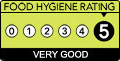
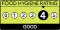
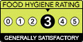
➜ Get more ratings from the Food Standards Agency
Nearest post box to CW7 9GU
| Last Collection | |||
|---|---|---|---|
| Location | Mon-Fri | Sat | Distance |
| Queens Hotel | 17:30 | 11:30 | 700m |
| Over So | 17:00 | 11:30 | 1,414m |
| St Georges Road | 17:30 | 11:30 | 1,418m |
CW7 9GU ITL and CW7 9GU LAU
The below table lists the International Territorial Level (ITL) codes (formerly Nomenclature of Territorial Units for Statistics (NUTS) codes) and Local Administrative Units (LAU) codes for CW7 9GU:
| ITL 1 Code | Name |
|---|---|
| TLD | North West (England) |
| ITL 2 Code | Name |
| TLD6 | Cheshire |
| ITL 3 Code | Name |
| TLD63 | Cheshire West and Chester |
| LAU 1 Code | Name |
| E06000050 | Cheshire West and Chester |
CW7 9GU census areas
The below table lists the Census Output Area (OA), Lower Layer Super Output Area (LSOA), and Middle Layer Super Output Area (MSOA) for CW7 9GU:
| Code | Name | |
|---|---|---|
| OA | E00094610 | |
| LSOA | E01018746 | Cheshire West and Chester 038C |
| MSOA | E02003888 | Cheshire West and Chester 038 |
Nearest postcodes to CW7 9GU
| CW7 2BJ | Lagos Grove | 104m |
| CW7 2BG | Bakers Lane | 145m |
| CW7 2DZ | Saville Rise | 163m |
| CW7 2AD | High Street | 221m |
| CW7 2BE | Overway | 227m |
| CW7 2GQ | Saville Court | 249m |
| CW7 2GP | Pimlott Drive | 272m |
| CW7 2AP | High Street | 284m |
| CW7 2BB | Coronation Avenue | 286m |
| CW7 2BA | Siddorn Street | 293m |


- Contains OS data © Crown copyright and database right (2026)
- Contains Royal Mail data © Royal Mail copyright and Database right (2026)
- Contains National Statistics data © Crown copyright and database right (2026)
- Data produced by Land Registry © Crown copyright (2026)
- Contains Environment Agency data licensed under the Open Government Licence v3.0
- Everything else © GetTheData Publishing Limited (2026)
GetTheData.com is owned and operated by GetTheData Publishing Limited.
Company Number: 11075184 · Registered in England and Wales.
Registered Office: 3rd Floor, 86-90 Paul Street, London, England, EC2A 4NE
By accessing our site you agree to us using cookies, and sharing information about your use of our site, in accordance with our privacy policy.