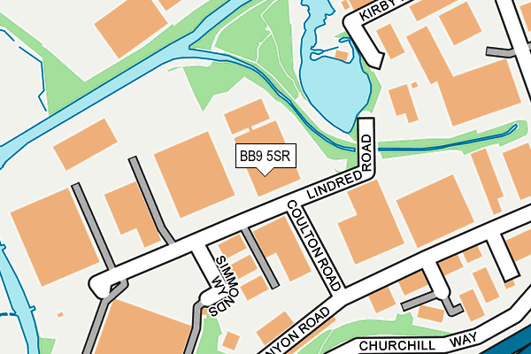
BB9 5SR is located in the Brierfield West & Reedley electoral ward, within the local authority district of Pendle and the English Parliamentary constituency of Pendle. The Sub Integrated Care Board (ICB) Location is NHS Lancashire and South Cumbria ICB - 01A and the police force is Lancashire. This postcode has been in use since February 1990.


GetTheData
Source: OS OpenMap – Local (Ordnance Survey)
Source: OS VectorMap District (Ordnance Survey)
Licence: Open Government Licence (requires attribution)
| Easting | 384595 |
| Northing | 437489 |
| Latitude | 53.833427 |
| Longitude | -2.235555 |
GetTheData
Source: Open Postcode Geo
Licence: Open Government Licence
| Country | England |
| Postcode District | BB9 |
| ➜ BB9 open data dashboard ➜ See where BB9 is on a map ➜ Where is Brierfield? | |
GetTheData
Source: Land Registry Price Paid Data
Licence: Open Government Licence
Elevation or altitude of BB9 5SR as distance above sea level:
| Metres | Feet | |
|---|---|---|
| Elevation | 110m | 361ft |
Elevation is measured from the approximate centre of the postcode, to the nearest point on an OS contour line from OS Terrain 50, which has contour spacing of ten vertical metres.
➜ How high above sea level am I? Find the elevation of your current position using your device's GPS.
GetTheData
Source: Open Postcode Elevation
Licence: Open Government Licence
| Ward | Brierfield West & Reedley |
| Constituency | Pendle |
GetTheData
Source: ONS Postcode Database
Licence: Open Government Licence
| January 2023 | Vehicle crime | On or near Calder Terrace | 468m |
| October 2022 | Burglary | On or near Calder Terrace | 468m |
| June 2022 | Burglary | On or near Calder Terrace | 468m |
| ➜ Get more crime data in our Crime section | |||
GetTheData
Source: data.police.uk
Licence: Open Government Licence
| Industrial Estate (Churchill Way) | Lomeshaye | 349m |
| Business Village (Lomeshaye Way) | Lomeshaye | 527m |
| Waggon And Horses (Colne Road) | Brierfield | 582m |
| Waggon And Horses (Colne Road) | Brierfield | 585m |
| Churchill Way (Manchester Road) | Lomeshaye | 613m |
| Brierfield Station | 1.1km |
| Nelson Station | 1.4km |
| Colne Station | 4.3km |
GetTheData
Source: NaPTAN
Licence: Open Government Licence
GetTheData
Source: ONS Postcode Database
Licence: Open Government Licence


➜ Get more ratings from the Food Standards Agency
GetTheData
Source: Food Standards Agency
Licence: FSA terms & conditions
| Last Collection | |||
|---|---|---|---|
| Location | Mon-Fri | Sat | Distance |
| Brierfield Post Office | 17:30 | 11:00 | 993m |
| Wheatley Lane, Fence | 16:00 | 10:30 | 1,022m |
| 46 Carr Road | 16:00 | 11:00 | 1,267m |
GetTheData
Source: Dracos
Licence: Creative Commons Attribution-ShareAlike
| Facility | Distance |
|---|---|
| Adpak Machinery Systems Ltd (Closed) Pendleside, Lomeshaye Industrial Estate, Nelson Sports Hall | 396m |
| Victoria Park (Nelson) Lomeshaye Way, Nelson Grass Pitches | 575m |
| The Leisure Box Glen Way, Brierfield Artificial Grass Pitch, Sports Hall, Health and Fitness Gym, Studio | 934m |
GetTheData
Source: Active Places
Licence: Open Government Licence
| School | Phase of Education | Distance |
|---|---|---|
| Lomeshaye Junior School Norfolk Street, Nelson, BB9 7SY | Primary | 1km |
| St John Southworth RC Primary School, A Voluntary Academy Lomeshaye Road, Nelson, BB9 0DQ | Primary | 1.1km |
| Marsden Heights Community College Edge End Lane, Nelson, BB9 0PR | Secondary | 1.1km |
GetTheData
Source: Edubase
Licence: Open Government Licence
| Risk of BB9 5SR flooding from rivers and sea | Low |
| ➜ BB9 5SR flood map | |
GetTheData
Source: Open Flood Risk by Postcode
Licence: Open Government Licence
The below table lists the International Territorial Level (ITL) codes (formerly Nomenclature of Territorial Units for Statistics (NUTS) codes) and Local Administrative Units (LAU) codes for BB9 5SR:
| ITL 1 Code | Name |
|---|---|
| TLD | North West (England) |
| ITL 2 Code | Name |
| TLD4 | Lancashire |
| ITL 3 Code | Name |
| TLD46 | East Lancashire |
| LAU 1 Code | Name |
| E07000122 | Pendle |
GetTheData
Source: ONS Postcode Directory
Licence: Open Government Licence
The below table lists the Census Output Area (OA), Lower Layer Super Output Area (LSOA), and Middle Layer Super Output Area (MSOA) for BB9 5SR:
| Code | Name | |
|---|---|---|
| OA | E00127836 | |
| LSOA | E01025185 | Pendle 013A |
| MSOA | E02005252 | Pendle 013 |
GetTheData
Source: ONS Postcode Directory
Licence: Open Government Licence
| BB9 5SP | Kenyon Road | 190m |
| BB9 6RS | Kirby Road | 270m |
| BB9 6RT | Churchill Way | 346m |
| BB9 7BL | Calder Terrace | 460m |
| BB9 7BJ | Ecroyd Street | 477m |
| BB9 5SX | Park View Close | 502m |
| BB9 7BN | Holme Terrace | 505m |
| BB9 5RF | Park View | 508m |
| BB9 7BH | Sun Street | 513m |
| BB9 7SH | Manchester Road | 531m |
GetTheData
Source: Open Postcode Geo; Land Registry Price Paid Data
Licence: Open Government Licence