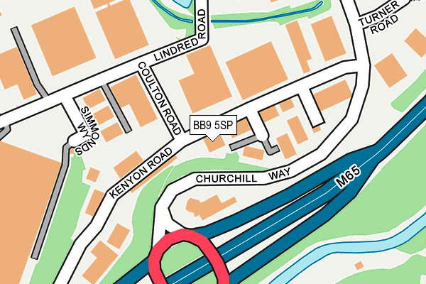
BB9 5SP lies on Kenyon Road in Brierfield, Nelson. BB9 5SP is located in the Brierfield West & Reedley electoral ward, within the local authority district of Pendle and the English Parliamentary constituency of Pendle. The Sub Integrated Care Board (ICB) Location is NHS Lancashire and South Cumbria ICB - 01A and the police force is Lancashire. This postcode has been in use since January 1983.


GetTheData
Source: OS OpenMap – Local (Ordnance Survey)
Source: OS VectorMap District (Ordnance Survey)
Licence: Open Government Licence (requires attribution)
| Easting | 384725 |
| Northing | 437350 |
| Latitude | 53.832182 |
| Longitude | -2.233573 |
GetTheData
Source: Open Postcode Geo
Licence: Open Government Licence
| Street | Kenyon Road |
| Locality | Brierfield |
| Town/City | Nelson |
| Country | England |
| Postcode District | BB9 |
➜ See where BB9 is on a map ➜ Where is Brierfield? | |
GetTheData
Source: Land Registry Price Paid Data
Licence: Open Government Licence
Elevation or altitude of BB9 5SP as distance above sea level:
| Metres | Feet | |
|---|---|---|
| Elevation | 120m | 394ft |
Elevation is measured from the approximate centre of the postcode, to the nearest point on an OS contour line from OS Terrain 50, which has contour spacing of ten vertical metres.
➜ How high above sea level am I? Find the elevation of your current position using your device's GPS.
GetTheData
Source: Open Postcode Elevation
Licence: Open Government Licence
| Ward | Brierfield West & Reedley |
| Constituency | Pendle |
GetTheData
Source: ONS Postcode Database
Licence: Open Government Licence
| Industrial Estate (Churchill Way) | Lomeshaye | 387m |
| Waggon And Horses (Colne Road) | Brierfield | 403m |
| Waggon And Horses (Colne Road) | Brierfield | 405m |
| Churchill Way (Manchester Road) | Lomeshaye | 437m |
| Churchill Way (Manchester Road) | Lomeshaye | 458m |
| Brierfield Station | 0.9km |
| Nelson Station | 1.3km |
| Colne Station | 4.2km |
GetTheData
Source: NaPTAN
Licence: Open Government Licence
| Median download speed | 80.0Mbps |
| Average download speed | 72.5Mbps |
| Maximum download speed | 80.00Mbps |
| Median upload speed | 20.0Mbps |
| Average upload speed | 18.8Mbps |
| Maximum upload speed | 20.00Mbps |
GetTheData
Source: Ofcom
Licence: Ofcom Terms of Use (requires attribution)
Estimated total energy consumption in BB9 5SP by fuel type, 2015.
| Consumption (kWh) | 275,003 |
|---|---|
| Meter count | 13 |
| Mean (kWh/meter) | 21,154 |
| Median (kWh/meter) | 8,518 |
GetTheData
Source: Postcode level gas estimates: 2015 (experimental)
Source: Postcode level electricity estimates: 2015 (experimental)
Licence: Open Government Licence
GetTheData
Source: ONS Postcode Database
Licence: Open Government Licence


➜ Get more ratings from the Food Standards Agency
GetTheData
Source: Food Standards Agency
Licence: FSA terms & conditions
| Last Collection | |||
|---|---|---|---|
| Location | Mon-Fri | Sat | Distance |
| Brierfield Post Office | 17:30 | 11:00 | 855m |
| Hill Place | 17:30 | 12:00 | 1,171m |
| Wheatley Lane, Fence | 16:00 | 10:30 | 1,212m |
GetTheData
Source: Dracos
Licence: Creative Commons Attribution-ShareAlike
The below table lists the International Territorial Level (ITL) codes (formerly Nomenclature of Territorial Units for Statistics (NUTS) codes) and Local Administrative Units (LAU) codes for BB9 5SP:
| ITL 1 Code | Name |
|---|---|
| TLD | North West (England) |
| ITL 2 Code | Name |
| TLD4 | Lancashire |
| ITL 3 Code | Name |
| TLD46 | East Lancashire |
| LAU 1 Code | Name |
| E07000122 | Pendle |
GetTheData
Source: ONS Postcode Directory
Licence: Open Government Licence
The below table lists the Census Output Area (OA), Lower Layer Super Output Area (LSOA), and Middle Layer Super Output Area (MSOA) for BB9 5SP:
| Code | Name | |
|---|---|---|
| OA | E00127836 | |
| LSOA | E01025185 | Pendle 013A |
| MSOA | E02005252 | Pendle 013 |
GetTheData
Source: ONS Postcode Directory
Licence: Open Government Licence
| BB9 5SX | Park View Close | 314m |
| BB9 5RF | Park View | 321m |
| BB9 6RS | Kirby Road | 340m |
| BB9 7SH | Manchester Road | 355m |
| BB9 5RE | Colne Road | 362m |
| BB9 5RG | Linedred Lane | 385m |
| BB9 5RD | Colne Road | 393m |
| BB9 6RT | Churchill Way | 423m |
| BB9 7SJ | Manchester Road | 438m |
| BB9 5RQ | Colne Road | 446m |
GetTheData
Source: Open Postcode Geo; Land Registry Price Paid Data
Licence: Open Government Licence