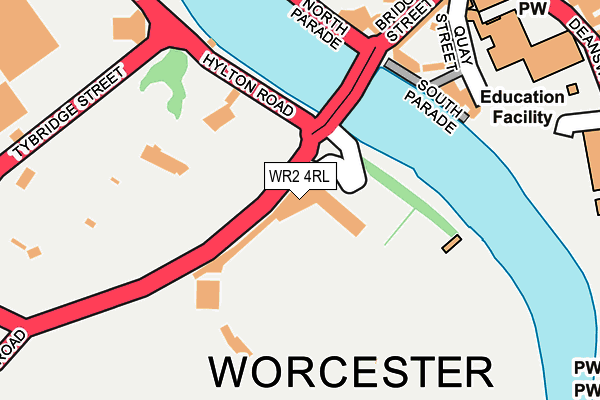
WR2 4RL is located in the Bedwardine electoral ward, within the local authority district of Worcester and the English Parliamentary constituency of Worcester. The Sub Integrated Care Board (ICB) Location is NHS Herefordshire and Worcestershire ICB - 18C and the police force is West Mercia. This postcode has been in use since September 2013.


GetTheData
Source: OS OpenMap – Local (Ordnance Survey)
Source: OS VectorMap District (Ordnance Survey)
Licence: Open Government Licence (requires attribution)
| Easting | 384593 |
| Northing | 254672 |
| Latitude | 52.190071 |
| Longitude | -2.226793 |
GetTheData
Source: Open Postcode Geo
Licence: Open Government Licence
| Country | England |
| Postcode District | WR2 |
➜ See where WR2 is on a map ➜ Where is Worcester? | |
GetTheData
Source: Land Registry Price Paid Data
Licence: Open Government Licence
Elevation or altitude of WR2 4RL as distance above sea level:
| Metres | Feet | |
|---|---|---|
| Elevation | 10m | 33ft |
Elevation is measured from the approximate centre of the postcode, to the nearest point on an OS contour line from OS Terrain 50, which has contour spacing of ten vertical metres.
➜ How high above sea level am I? Find the elevation of your current position using your device's GPS.
GetTheData
Source: Open Postcode Elevation
Licence: Open Government Licence
| Ward | Bedwardine |
| Constituency | Worcester |
GetTheData
Source: ONS Postcode Database
Licence: Open Government Licence
| The Hive (The Butts (B4205)) | Worcester | 382m |
| Bromwich Lane (A449) | St John's | 390m |
| Bull Ring | St John's | 408m |
| Arena (Hylton Road) | St John's | 428m |
| Bull Ring (A44) | St John's | 452m |
| Worcester Foregate Street Station | 0.7km |
| Worcester Shrub Hill Station | 1.3km |
GetTheData
Source: NaPTAN
Licence: Open Government Licence
GetTheData
Source: ONS Postcode Database
Licence: Open Government Licence


➜ Get more ratings from the Food Standards Agency
GetTheData
Source: Food Standards Agency
Licence: FSA terms & conditions
| Last Collection | |||
|---|---|---|---|
| Location | Mon-Fri | Sat | Distance |
| St Clements Close | 16:00 | 11:30 | 383m |
| High Street | 18:30 | 11:30 | 438m |
| College Street | 18:30 | 11:30 | 447m |
GetTheData
Source: Dracos
Licence: Creative Commons Attribution-ShareAlike
| Risk of WR2 4RL flooding from rivers and sea | High |
| ➜ WR2 4RL flood map | |
GetTheData
Source: Open Flood Risk by Postcode
Licence: Open Government Licence
The below table lists the International Territorial Level (ITL) codes (formerly Nomenclature of Territorial Units for Statistics (NUTS) codes) and Local Administrative Units (LAU) codes for WR2 4RL:
| ITL 1 Code | Name |
|---|---|
| TLG | West Midlands (England) |
| ITL 2 Code | Name |
| TLG1 | Herefordshire, Worcestershire and Warwickshire |
| ITL 3 Code | Name |
| TLG12 | Worcestershire CC |
| LAU 1 Code | Name |
| E07000237 | Worcester |
GetTheData
Source: ONS Postcode Directory
Licence: Open Government Licence
The below table lists the Census Output Area (OA), Lower Layer Super Output Area (LSOA), and Middle Layer Super Output Area (MSOA) for WR2 4RL:
| Code | Name | |
|---|---|---|
| OA | E00164681 | |
| LSOA | E01032288 | Worcester 012C |
| MSOA | E02006745 | Worcester 012 |
GetTheData
Source: ONS Postcode Directory
Licence: Open Government Licence
| WR1 2JJ | Quay Street | 185m |
| WR1 2JN | South Quay | 191m |
| WR1 3NN | North Parade | 202m |
| WR1 3NR | Newport Street | 226m |
| WR1 3NJ | Bridge Street | 228m |
| WR1 3NG | Newport Street | 263m |
| WR1 3LX | Moreton Place | 281m |
| WR2 5BA | Tybridge Street | 292m |
| WR1 3NH | Broad Street | 308m |
| WR1 3LR | Broad Street | 356m |
GetTheData
Source: Open Postcode Geo; Land Registry Price Paid Data
Licence: Open Government Licence