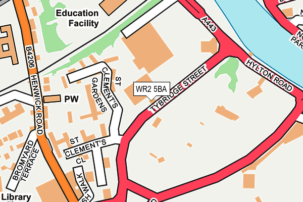
WR2 5BA lies on Tybridge Street in Worcester. WR2 5BA is located in the St John electoral ward, within the local authority district of Worcester and the English Parliamentary constituency of Worcester. The Sub Integrated Care Board (ICB) Location is NHS Herefordshire and Worcestershire ICB - 18C and the police force is West Mercia. This postcode has been in use since January 1980.


GetTheData
Source: OS OpenMap – Local (Ordnance Survey)
Source: OS VectorMap District (Ordnance Survey)
Licence: Open Government Licence (requires attribution)
| Easting | 384308 |
| Northing | 254736 |
| Latitude | 52.190638 |
| Longitude | -2.230965 |
GetTheData
Source: Open Postcode Geo
Licence: Open Government Licence
| Street | Tybridge Street |
| Town/City | Worcester |
| Country | England |
| Postcode District | WR2 |
➜ See where WR2 is on a map ➜ Where is Worcester? | |
GetTheData
Source: Land Registry Price Paid Data
Licence: Open Government Licence
Elevation or altitude of WR2 5BA as distance above sea level:
| Metres | Feet | |
|---|---|---|
| Elevation | 20m | 66ft |
Elevation is measured from the approximate centre of the postcode, to the nearest point on an OS contour line from OS Terrain 50, which has contour spacing of ten vertical metres.
➜ How high above sea level am I? Find the elevation of your current position using your device's GPS.
GetTheData
Source: Open Postcode Elevation
Licence: Open Government Licence
| Ward | St John |
| Constituency | Worcester |
GetTheData
Source: ONS Postcode Database
Licence: Open Government Licence
TYBRIDGE HOUSE, 45, TYBRIDGE STREET, WORCESTER, WR2 5BA 2002 23 DEC £213,250 |
GetTheData
Source: HM Land Registry Price Paid Data
Licence: Contains HM Land Registry data © Crown copyright and database right 2025. This data is licensed under the Open Government Licence v3.0.
| Bull Ring | St John's | 225m |
| Level Crossing (Henwick Road) | St John's | 240m |
| Level Crossing (Henwick Road (B4206)) | St John's | 242m |
| Bull Ring (Henwick Road) | St John's | 250m |
| Bull Ring (A44) | St John's | 260m |
| Worcester Foregate Street Station | 0.8km |
| Worcester Shrub Hill Station | 1.5km |
GetTheData
Source: NaPTAN
Licence: Open Government Licence
GetTheData
Source: ONS Postcode Database
Licence: Open Government Licence


➜ Get more ratings from the Food Standards Agency
GetTheData
Source: Food Standards Agency
Licence: FSA terms & conditions
| Last Collection | |||
|---|---|---|---|
| Location | Mon-Fri | Sat | Distance |
| St Clements Close | 16:00 | 11:30 | 122m |
| St Johns P.o. | 17:30 | 11:30 | 257m |
| Upper Henwick | 17:00 | 11:30 | 380m |
GetTheData
Source: Dracos
Licence: Creative Commons Attribution-ShareAlike
| Risk of WR2 5BA flooding from rivers and sea | High |
| ➜ WR2 5BA flood map | |
GetTheData
Source: Open Flood Risk by Postcode
Licence: Open Government Licence
The below table lists the International Territorial Level (ITL) codes (formerly Nomenclature of Territorial Units for Statistics (NUTS) codes) and Local Administrative Units (LAU) codes for WR2 5BA:
| ITL 1 Code | Name |
|---|---|
| TLG | West Midlands (England) |
| ITL 2 Code | Name |
| TLG1 | Herefordshire, Worcestershire and Warwickshire |
| ITL 3 Code | Name |
| TLG12 | Worcestershire CC |
| LAU 1 Code | Name |
| E07000237 | Worcester |
GetTheData
Source: ONS Postcode Directory
Licence: Open Government Licence
The below table lists the Census Output Area (OA), Lower Layer Super Output Area (LSOA), and Middle Layer Super Output Area (MSOA) for WR2 5BA:
| Code | Name | |
|---|---|---|
| OA | E00164845 | |
| LSOA | E01032322 | Worcester 009E |
| MSOA | E02006742 | Worcester 009 |
GetTheData
Source: ONS Postcode Directory
Licence: Open Government Licence
| WR2 5NW | St Clements Court | 129m |
| WR2 5NP | Henwick Road | 213m |
| WR2 5AA | Bull Ring | 268m |
| WR2 5BJ | Grosvenor Walk | 292m |
| WR2 5BW | Bromyard Terrace | 306m |
| WR2 5AE | St Johns | 316m |
| WR2 4BH | Bromwich Lane | 319m |
| WR2 5AH | St Johns | 321m |
| WR2 4EL | Swanpool Walk | 326m |
| WR2 4AA | Bromwich Road | 326m |
GetTheData
Source: Open Postcode Geo; Land Registry Price Paid Data
Licence: Open Government Licence