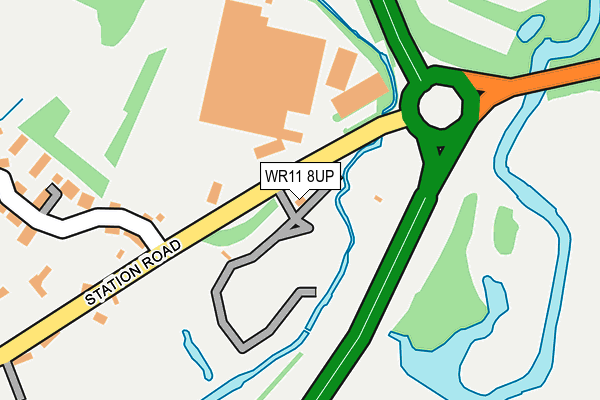
WR11 8UP is located in the Salford Priors & Alcester Rural electoral ward, within the local authority district of Stratford-on-Avon and the English Parliamentary constituency of Stratford-on-Avon. The Sub Integrated Care Board (ICB) Location is NHS Coventry and Warwickshire ICB - B2M3M and the police force is Warwickshire. This postcode has been in use since December 2001.


GetTheData
Source: OS OpenMap – Local (Ordnance Survey)
Source: OS VectorMap District (Ordnance Survey)
Licence: Open Government Licence (requires attribution)
| Easting | 408071 |
| Northing | 251277 |
| Latitude | 52.159710 |
| Longitude | -1.883433 |
GetTheData
Source: Open Postcode Geo
Licence: Open Government Licence
| Country | England |
| Postcode District | WR11 |
| ➜ WR11 open data dashboard ➜ See where WR11 is on a map ➜ Where is Salford Priors? | |
GetTheData
Source: Land Registry Price Paid Data
Licence: Open Government Licence
Elevation or altitude of WR11 8UP as distance above sea level:
| Metres | Feet | |
|---|---|---|
| Elevation | 30m | 98ft |
Elevation is measured from the approximate centre of the postcode, to the nearest point on an OS contour line from OS Terrain 50, which has contour spacing of ten vertical metres.
➜ How high above sea level am I? Find the elevation of your current position using your device's GPS.
GetTheData
Source: Open Postcode Elevation
Licence: Open Government Licence
| Ward | Salford Priors & Alcester Rural |
| Constituency | Stratford-on-avon |
GetTheData
Source: ONS Postcode Database
Licence: Open Government Licence
| May 2022 | Burglary | On or near Ban Brook Road | 496m |
| March 2022 | Other theft | On or near Station Road | 172m |
| March 2022 | Other theft | On or near Station Road | 172m |
| ➜ Get more crime data in our Crime section | |||
GetTheData
Source: data.police.uk
Licence: Open Government Licence
| Willow Park (Station Road) | Salford Priors | 18m |
| Spearhead (Station Road) | Salford Priors | 49m |
| Church (Station Road) | Salford Priors | 425m |
| Ban Brook Road (School Road) | Salford Priors | 545m |
| Ban Brook Road (School Road) | Salford Priors | 546m |
GetTheData
Source: NaPTAN
Licence: Open Government Licence
| Median download speed | 47.1Mbps |
| Average download speed | 39.0Mbps |
| Maximum download speed | 55.00Mbps |
| Median upload speed | 9.6Mbps |
| Average upload speed | 7.5Mbps |
| Maximum upload speed | 10.00Mbps |
GetTheData
Source: Ofcom
Licence: Ofcom Terms of Use (requires attribution)
GetTheData
Source: ONS Postcode Database
Licence: Open Government Licence


➜ Get more ratings from the Food Standards Agency
GetTheData
Source: Food Standards Agency
Licence: FSA terms & conditions
| Last Collection | |||
|---|---|---|---|
| Location | Mon-Fri | Sat | Distance |
| Evesham Road | 16:45 | 10:15 | 752m |
| Salford Priors P.o. | 16:45 | 09:00 | 1,134m |
| Abbots Salford | 16:45 | 10:30 | 1,497m |
GetTheData
Source: Dracos
Licence: Creative Commons Attribution-ShareAlike
| Facility | Distance |
|---|---|
| Salford Priors Playing Field School Avenue, Salford Priors, Evesham Grass Pitches | 862m |
| Salford Priors C Of E Primary Academy School Road, Salford Priors, Evesham Grass Pitches, Sports Hall | 907m |
| Dugdale Sports Field Dugdale Avenue, Bidford-on-avon, Alcester Grass Pitches | 1.3km |
GetTheData
Source: Active Places
Licence: Open Government Licence
| School | Phase of Education | Distance |
|---|---|---|
| Salford Priors CofE Academy School Road, Salford Priors, Evesham, WR11 8XD | Primary | 907m |
| Bidford-on-Avon CofE Primary School Bramley Way, Bidford-on-Avon, Alcester, B50 4QG | Primary | 1.8km |
| Cleeve Prior CofE (Controlled) Primary School Main Street, Cleeve Prior, Evesham, WR11 8LG | Primary | 2.2km |
GetTheData
Source: Edubase
Licence: Open Government Licence
| Risk of WR11 8UP flooding from rivers and sea | High |
| ➜ WR11 8UP flood map | |
GetTheData
Source: Open Flood Risk by Postcode
Licence: Open Government Licence
The below table lists the International Territorial Level (ITL) codes (formerly Nomenclature of Territorial Units for Statistics (NUTS) codes) and Local Administrative Units (LAU) codes for WR11 8UP:
| ITL 1 Code | Name |
|---|---|
| TLG | West Midlands (England) |
| ITL 2 Code | Name |
| TLG1 | Herefordshire, Worcestershire and Warwickshire |
| ITL 3 Code | Name |
| TLG13 | Warwickshire CC |
| LAU 1 Code | Name |
| E07000221 | Stratford-on-Avon |
GetTheData
Source: ONS Postcode Directory
Licence: Open Government Licence
The below table lists the Census Output Area (OA), Lower Layer Super Output Area (LSOA), and Middle Layer Super Output Area (MSOA) for WR11 8UP:
| Code | Name | |
|---|---|---|
| OA | E00159005 | |
| LSOA | E01031189 | Stratford-on-Avon 012A |
| MSOA | E02006515 | Stratford-on-Avon 012 |
GetTheData
Source: ONS Postcode Directory
Licence: Open Government Licence
| WR11 8UX | Station Road | 317m |
| WR11 8XG | Garrard Close | 398m |
| WR11 8GW | Ban Brook Copse | 433m |
| WR11 8XQ | Sanders Road | 505m |
| WR11 8XH | Hedges Close | 519m |
| WR11 8XE | Banbrook Road | 537m |
| WR11 8XF | Cherry Tree Crescent | 562m |
| WR11 8XL | Periwinkle Cottages | 581m |
| WR11 8UU | Evesham Road | 718m |
| WR11 8UW | Evesham Road | 756m |
GetTheData
Source: Open Postcode Geo; Land Registry Price Paid Data
Licence: Open Government Licence