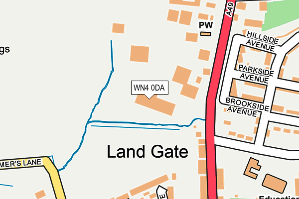
WN4 0DA is located in the Bryn with Ashton-in-Makerfield North electoral ward, within the metropolitan district of Wigan and the English Parliamentary constituency of Makerfield. The Sub Integrated Care Board (ICB) Location is NHS Greater Manchester ICB - 02H and the police force is Greater Manchester. This postcode has been in use since February 2008.


GetTheData
Source: OS OpenMap – Local (Ordnance Survey)
Source: OS VectorMap District (Ordnance Survey)
Licence: Open Government Licence (requires attribution)
| Easting | 356785 |
| Northing | 401511 |
| Latitude | 53.508513 |
| Longitude | -2.653075 |
GetTheData
Source: Open Postcode Geo
Licence: Open Government Licence
| Country | England |
| Postcode District | WN4 |
| ➜ WN4 open data dashboard ➜ See where WN4 is on a map ➜ Where is Land Gate? | |
GetTheData
Source: Land Registry Price Paid Data
Licence: Open Government Licence
Elevation or altitude of WN4 0DA as distance above sea level:
| Metres | Feet | |
|---|---|---|
| Elevation | 60m | 197ft |
Elevation is measured from the approximate centre of the postcode, to the nearest point on an OS contour line from OS Terrain 50, which has contour spacing of ten vertical metres.
➜ How high above sea level am I? Find the elevation of your current position using your device's GPS.
GetTheData
Source: Open Postcode Elevation
Licence: Open Government Licence
| Ward | Bryn With Ashton-in-makerfield North |
| Constituency | Makerfield |
GetTheData
Source: ONS Postcode Database
Licence: Open Government Licence
| Wigan Rd/Land Gate (Wigan Rd) | Land Gate | 132m |
| Wigan Rd/Land Gate (Wigan Rd) | Land Gate | 165m |
| Wigan Rd/Park Ln Chapel (Wigan Rd) | Land Gate | 179m |
| Dovedale Road (N Bnd) (Dovedale Road) | Land Gate | 210m |
| Land Gate Lane (W Bnd) (Land Gate Lane) | Land Gate | 213m |
| Bryn Station | 1km |
| Garswood Station | 2.6km |
| Pemberton Station | 2.7km |
GetTheData
Source: NaPTAN
Licence: Open Government Licence
GetTheData
Source: ONS Postcode Database
Licence: Open Government Licence


➜ Get more ratings from the Food Standards Agency
GetTheData
Source: Food Standards Agency
Licence: FSA terms & conditions
| Last Collection | |||
|---|---|---|---|
| Location | Mon-Fri | Sat | Distance |
| Frederick Street | 18:00 | 11:00 | 1,554m |
| Ashland Avenue | 18:00 | 11:20 | 1,659m |
| Tanhouse Drive | 18:00 | 12:20 | 1,829m |
GetTheData
Source: Dracos
Licence: Creative Commons Attribution-ShareAlike
| Facility | Distance |
|---|---|
| Bryn St. Peters Ce Primary School Downall Green Road, Ashton-in-makerfield, Wigan Grass Pitches | 757m |
| Cm Health & Fitness (Closed) Haseldine Street, Ashton-in-makerfield, Wigan Health and Fitness Gym | 806m |
| Bryn Recreation Ground Bryn Road, Ashton-in-makerfield, Wigan Grass Pitches | 884m |
GetTheData
Source: Active Places
Licence: Open Government Licence
| School | Phase of Education | Distance |
|---|---|---|
| Landgate School, Bryn Landgate Lane, Ashton-in-Makerfield, Bryn, Wigan, WN4 0EP | Not applicable | 258m |
| Bryn St Peter's CofE Primary School Downall Green Road, Ashton-in-Makerfield, Wigan, WN4 0DL | Primary | 766m |
| Nicol Mere School Roman Road, Ashton-in-Makerfield, Wigan, WN4 8DF | Primary | 1.4km |
GetTheData
Source: Edubase
Licence: Open Government Licence
The below table lists the International Territorial Level (ITL) codes (formerly Nomenclature of Territorial Units for Statistics (NUTS) codes) and Local Administrative Units (LAU) codes for WN4 0DA:
| ITL 1 Code | Name |
|---|---|
| TLD | North West (England) |
| ITL 2 Code | Name |
| TLD3 | Greater Manchester |
| ITL 3 Code | Name |
| TLD36 | Greater Manchester North West |
| LAU 1 Code | Name |
| E08000010 | Wigan |
GetTheData
Source: ONS Postcode Directory
Licence: Open Government Licence
The below table lists the Census Output Area (OA), Lower Layer Super Output Area (LSOA), and Middle Layer Super Output Area (MSOA) for WN4 0DA:
| Code | Name | |
|---|---|---|
| OA | E00031738 | |
| LSOA | E01006262 | Wigan 032A |
| MSOA | E02001318 | Wigan 032 |
GetTheData
Source: ONS Postcode Directory
Licence: Open Government Licence
| WN4 0BX | Wigan Road | 175m |
| WN4 0BY | Wigan Road | 186m |
| WN4 0DR | Brookside Avenue | 187m |
| WN4 0JR | Kielder Close | 195m |
| WN4 0DS | Parkside Avenue | 208m |
| WN4 0JS | Soughers Lane | 257m |
| WN4 0JU | Drummers Lane | 300m |
| WN4 0SX | Dovedale Road | 301m |
| WN4 0BP | Cranberry Court | 351m |
| WN4 0EA | Yewdale Road | 375m |
GetTheData
Source: Open Postcode Geo; Land Registry Price Paid Data
Licence: Open Government Licence