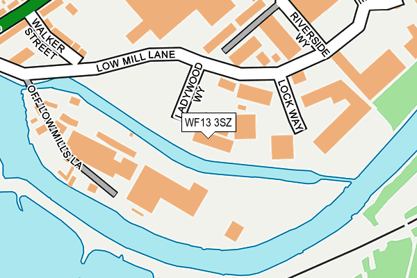
WF13 3SZ is located in the Dewsbury West electoral ward, within the metropolitan district of Kirklees and the English Parliamentary constituency of Dewsbury. The Sub Integrated Care Board (ICB) Location is NHS West Yorkshire ICB - X2C4Y and the police force is West Yorkshire. This postcode has been in use since September 2011.


GetTheData
Source: OS OpenMap – Local (Ordnance Survey)
Source: OS VectorMap District (Ordnance Survey)
Licence: Open Government Licence (requires attribution)
| Easting | 422043 |
| Northing | 419814 |
| Latitude | 53.674350 |
| Longitude | -1.667808 |
GetTheData
Source: Open Postcode Geo
Licence: Open Government Licence
| Country | England |
| Postcode District | WF13 |
| ➜ WF13 open data dashboard ➜ See where WF13 is on a map ➜ Where is Dewsbury? | |
GetTheData
Source: Land Registry Price Paid Data
Licence: Open Government Licence
Elevation or altitude of WF13 3SZ as distance above sea level:
| Metres | Feet | |
|---|---|---|
| Elevation | 40m | 131ft |
Elevation is measured from the approximate centre of the postcode, to the nearest point on an OS contour line from OS Terrain 50, which has contour spacing of ten vertical metres.
➜ How high above sea level am I? Find the elevation of your current position using your device's GPS.
GetTheData
Source: Open Postcode Elevation
Licence: Open Government Licence
| Ward | Dewsbury West |
| Constituency | Dewsbury |
GetTheData
Source: ONS Postcode Database
Licence: Open Government Licence
| January 2024 | Violence and sexual offences | On or near Low Mill Lane | 130m |
| December 2023 | Vehicle crime | On or near Lee Road | 422m |
| November 2023 | Vehicle crime | On or near Low Mill Lane | 130m |
| ➜ Get more crime data in our Crime section | |||
GetTheData
Source: data.police.uk
Licence: Open Government Licence
| Huddersfield Road Fir Parade (Huddersfield Road) | Ravensthorpe | 301m |
| Huddersfield Road Fir Parade (Huddersfield Road) | Ravensthorpe | 313m |
| Huddersfield Rd George Street (Huddersfield Road) | Ravensthorpe | 355m |
| Huddersfield Rd Fir Avenue (Huddersfield Road) | Ravensthorpe | 376m |
| Huddersfield Road Bradbury St (Huddersfield Road) | Ravensthorpe | 383m |
| Ravensthorpe Station | 0.8km |
| Mirfield Station | 1.7km |
| Dewsbury Station | 3km |
GetTheData
Source: NaPTAN
Licence: Open Government Licence
GetTheData
Source: ONS Postcode Database
Licence: Open Government Licence


➜ Get more ratings from the Food Standards Agency
GetTheData
Source: Food Standards Agency
Licence: FSA terms & conditions
| Last Collection | |||
|---|---|---|---|
| Location | Mon-Fri | Sat | Distance |
| Fir Parade/Huddersfield Road | 17:45 | 12:30 | 323m |
| Havelock Street | 18:30 | 404m | |
| Ravensthorpe P.o. | 17:45 | 12:00 | 473m |
GetTheData
Source: Dracos
Licence: Creative Commons Attribution-ShareAlike
| Facility | Distance |
|---|---|
| Ravensthorpe Community Centre Ltd Garden Street, Dewsbury Sports Hall | 586m |
| Fitness Connection Foundry Street, Ravensthorpe, Dewsbury Health and Fitness Gym | 592m |
| Holroyd Park The Crescent, Dewsbury Grass Pitches | 596m |
GetTheData
Source: Active Places
Licence: Open Government Licence
| School | Phase of Education | Distance |
|---|---|---|
| Ravensthorpe Church of England Voluntary Controlled Junior School Myrtle Road, Ravensthorpe, Dewsbury, WF13 3AS | Primary | 575m |
| Diamond Wood Community Academy North Road, Ravensthorpe, Dewsbury, WF13 3AD | Primary | 710m |
| Ravenshall School Ravensthorpe Road, Thornhill Lees, Dewsbury, WF12 9EE | Not applicable | 1.3km |
GetTheData
Source: Edubase
Licence: Open Government Licence
| Risk of WF13 3SZ flooding from rivers and sea | High |
| ➜ WF13 3SZ flood map | |
GetTheData
Source: Open Flood Risk by Postcode
Licence: Open Government Licence
The below table lists the International Territorial Level (ITL) codes (formerly Nomenclature of Territorial Units for Statistics (NUTS) codes) and Local Administrative Units (LAU) codes for WF13 3SZ:
| ITL 1 Code | Name |
|---|---|
| TLE | Yorkshire and The Humber |
| ITL 2 Code | Name |
| TLE4 | West Yorkshire |
| ITL 3 Code | Name |
| TLE44 | Calderdale and Kirklees |
| LAU 1 Code | Name |
| E08000034 | Kirklees |
GetTheData
Source: ONS Postcode Directory
Licence: Open Government Licence
The below table lists the Census Output Area (OA), Lower Layer Super Output Area (LSOA), and Middle Layer Super Output Area (MSOA) for WF13 3SZ:
| Code | Name | |
|---|---|---|
| OA | E00056106 | |
| LSOA | E01011133 | Kirklees 023A |
| MSOA | E02002293 | Kirklees 023 |
GetTheData
Source: ONS Postcode Directory
Licence: Open Government Licence
| WF13 3SX | Lock Way | 107m |
| WF13 3LS | Walker Street | 261m |
| WF13 3LP | Armitage Street | 277m |
| WF13 3LR | Huddersfield Road | 285m |
| WF13 3LW | William Street | 291m |
| WF13 3LL | George Street | 307m |
| WF13 3LZ | Huddersfield Road | 324m |
| WF13 3LT | Huddersfield Road | 326m |
| WF13 3JA | Huddersfield Road | 326m |
| WF13 3LY | Huddersfield Road | 345m |
GetTheData
Source: Open Postcode Geo; Land Registry Price Paid Data
Licence: Open Government Licence