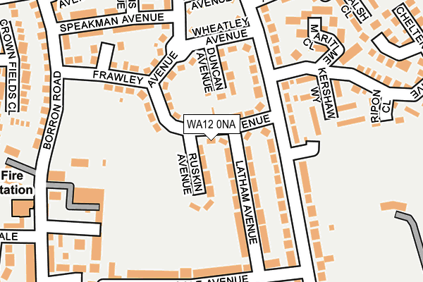
WA12 0NA is located in the Newton-le-Willows West electoral ward, within the metropolitan district of St. Helens and the English Parliamentary constituency of St Helens North. The Sub Integrated Care Board (ICB) Location is NHS Cheshire and Merseyside ICB - 01X and the police force is Merseyside. This postcode has been in use since January 1980.


GetTheData
Source: OS OpenMap – Local (Ordnance Survey)
Source: OS VectorMap District (Ordnance Survey)
Licence: Open Government Licence (requires attribution)
| Easting | 358185 |
| Northing | 395975 |
| Latitude | 53.458855 |
| Longitude | -2.631227 |
GetTheData
Source: Open Postcode Geo
Licence: Open Government Licence
| Country | England |
| Postcode District | WA12 |
| ➜ WA12 open data dashboard ➜ See where WA12 is on a map ➜ Where is Newton-le-Willows? | |
GetTheData
Source: Land Registry Price Paid Data
Licence: Open Government Licence
Elevation or altitude of WA12 0NA as distance above sea level:
| Metres | Feet | |
|---|---|---|
| Elevation | 30m | 98ft |
Elevation is measured from the approximate centre of the postcode, to the nearest point on an OS contour line from OS Terrain 50, which has contour spacing of ten vertical metres.
➜ How high above sea level am I? Find the elevation of your current position using your device's GPS.
GetTheData
Source: Open Postcode Elevation
Licence: Open Government Licence
| Ward | Newton-le-willows West |
| Constituency | St Helens North |
GetTheData
Source: ONS Postcode Database
Licence: Open Government Licence
| June 2023 | Anti-social behaviour | On or near Cheltenham Drive | 214m |
| May 2023 | Violence and sexual offences | On or near Cheltenham Drive | 214m |
| May 2023 | Violence and sexual offences | On or near Cheltenham Drive | 214m |
| ➜ Get more crime data in our Crime section | |||
GetTheData
Source: data.police.uk
Licence: Open Government Licence
| Davies Avenue (Queens Drive) | Crow Lane | 104m |
| Cheltenham Drive (Queens Drive) | Crow Lane | 108m |
| Cole Avenue (Queens Drive) | Crow Lane | 205m |
| Sanderling Road (Crow Lane East) | Crow Lane | 286m |
| Mullins Avenue (Queens Drive) | Crow Lane | 306m |
| Earlestown Station | 1km |
| Newton-le-Willows Station | 1.3km |
| Garswood Station | 4.3km |
GetTheData
Source: NaPTAN
Licence: Open Government Licence
| Percentage of properties with Next Generation Access | 100.0% |
| Percentage of properties with Superfast Broadband | 100.0% |
| Percentage of properties with Ultrafast Broadband | 100.0% |
| Percentage of properties with Full Fibre Broadband | 0.0% |
Superfast Broadband is between 30Mbps and 300Mbps
Ultrafast Broadband is > 300Mbps
| Percentage of properties unable to receive 2Mbps | 0.0% |
| Percentage of properties unable to receive 5Mbps | 0.0% |
| Percentage of properties unable to receive 10Mbps | 0.0% |
| Percentage of properties unable to receive 30Mbps | 0.0% |
GetTheData
Source: Ofcom
Licence: Ofcom Terms of Use (requires attribution)
GetTheData
Source: ONS Postcode Database
Licence: Open Government Licence


➜ Get more ratings from the Food Standards Agency
GetTheData
Source: Food Standards Agency
Licence: FSA terms & conditions
| Last Collection | |||
|---|---|---|---|
| Location | Mon-Fri | Sat | Distance |
| 12 Davies Avenue | 16:15 | 11:00 | 38m |
| Crow Lane S.o. | 16:30 | 12:00 | 319m |
| Sanderling Way | 16:30 | 11:00 | 366m |
GetTheData
Source: Dracos
Licence: Creative Commons Attribution-ShareAlike
| Facility | Distance |
|---|---|
| Newton Sports Club Crow Lane East, Newton-le-willows Grass Pitches, Outdoor Tennis Courts | 282m |
| The Hive (Earlestown Athletic Jfc) Harrison Way, Newton-le-willows Grass Pitches | 500m |
| Hope Academy Ashton Road, Newton-le-willows Sports Hall, Studio, Grass Pitches | 534m |
GetTheData
Source: Active Places
Licence: Open Government Licence
| School | Phase of Education | Distance |
|---|---|---|
| St Mary's Catholic Infant School Victoria Road, Newton-le-Willows, St Helens, WA12 9RX | Primary | 327m |
| St Mary's Catholic Academy Infant School Victoria Road, Newton-le-Willows, St Helens, WA12 9RX | Primary | 327m |
| Hope Academy Ashton Road, Newton-le-Willows, WA12 0AQ | Secondary | 536m |
GetTheData
Source: Edubase
Licence: Open Government Licence
The below table lists the International Territorial Level (ITL) codes (formerly Nomenclature of Territorial Units for Statistics (NUTS) codes) and Local Administrative Units (LAU) codes for WA12 0NA:
| ITL 1 Code | Name |
|---|---|
| TLD | North West (England) |
| ITL 2 Code | Name |
| TLD7 | Merseyside |
| ITL 3 Code | Name |
| TLD71 | East Merseyside |
| LAU 1 Code | Name |
| E08000013 | St. Helens |
GetTheData
Source: ONS Postcode Directory
Licence: Open Government Licence
The below table lists the Census Output Area (OA), Lower Layer Super Output Area (LSOA), and Middle Layer Super Output Area (MSOA) for WA12 0NA:
| Code | Name | |
|---|---|---|
| OA | E00034826 | |
| LSOA | E01006868 | St. Helens 010C |
| MSOA | E02001415 | St. Helens 010 |
GetTheData
Source: ONS Postcode Directory
Licence: Open Government Licence
| WA12 0NB | Davies Avenue | 48m |
| WA12 0EG | Latham Avenue | 92m |
| WA12 0LY | Queens Drive | 119m |
| WA12 0ND | Frawley Avenue | 154m |
| WA12 0LT | Wheatley Avenue | 164m |
| WA12 0LX | Queens Drive | 183m |
| WA12 0EF | Cole Avenue | 188m |
| WA12 0EA | Queens Drive | 193m |
| WA12 0LS | Wightman Avenue | 196m |
| WA12 0NW | Speakman Avenue | 208m |
GetTheData
Source: Open Postcode Geo; Land Registry Price Paid Data
Licence: Open Government Licence