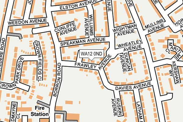
WA12 0ND lies on Frawley Avenue in Newton-le-willows. WA12 0ND is located in the Newton-le-Willows West electoral ward, within the metropolitan district of St. Helens and the English Parliamentary constituency of St Helens North. The Sub Integrated Care Board (ICB) Location is NHS Cheshire and Merseyside ICB - 01X and the police force is Merseyside. This postcode has been in use since January 1980.


GetTheData
Source: OS OpenMap – Local (Ordnance Survey)
Source: OS VectorMap District (Ordnance Survey)
Licence: Open Government Licence (requires attribution)
| Easting | 358072 |
| Northing | 396080 |
| Latitude | 53.459789 |
| Longitude | -2.632943 |
GetTheData
Source: Open Postcode Geo
Licence: Open Government Licence
| Street | Frawley Avenue |
| Town/City | Newton-le-willows |
| Country | England |
| Postcode District | WA12 |
➜ See where WA12 is on a map ➜ Where is Newton-le-Willows? | |
GetTheData
Source: Land Registry Price Paid Data
Licence: Open Government Licence
Elevation or altitude of WA12 0ND as distance above sea level:
| Metres | Feet | |
|---|---|---|
| Elevation | 30m | 98ft |
Elevation is measured from the approximate centre of the postcode, to the nearest point on an OS contour line from OS Terrain 50, which has contour spacing of ten vertical metres.
➜ How high above sea level am I? Find the elevation of your current position using your device's GPS.
GetTheData
Source: Open Postcode Elevation
Licence: Open Government Licence
| Ward | Newton-le-willows West |
| Constituency | St Helens North |
GetTheData
Source: ONS Postcode Database
Licence: Open Government Licence
| Cheltenham Drive (Queens Drive) | Crow Lane | 196m |
| Davies Avenue (Queens Drive) | Crow Lane | 219m |
| Mullins Avenue (Queens Drive) | Crow Lane | 239m |
| Billington Avenue (Queens Drive) | Crow Lane | 264m |
| Weedon Avenue (Belvedere Road) | Crow Lane | 297m |
| Earlestown Station | 1km |
| Newton-le-Willows Station | 1.5km |
| Garswood Station | 4.1km |
GetTheData
Source: NaPTAN
Licence: Open Government Licence
| Percentage of properties with Next Generation Access | 100.0% |
| Percentage of properties with Superfast Broadband | 100.0% |
| Percentage of properties with Ultrafast Broadband | 76.9% |
| Percentage of properties with Full Fibre Broadband | 0.0% |
Superfast Broadband is between 30Mbps and 300Mbps
Ultrafast Broadband is > 300Mbps
| Median download speed | 40.0Mbps |
| Average download speed | 54.7Mbps |
| Maximum download speed | 200.00Mbps |
| Median upload speed | 9.8Mbps |
| Average upload speed | 7.7Mbps |
| Maximum upload speed | 20.00Mbps |
| Percentage of properties unable to receive 2Mbps | 0.0% |
| Percentage of properties unable to receive 5Mbps | 0.0% |
| Percentage of properties unable to receive 10Mbps | 0.0% |
| Percentage of properties unable to receive 30Mbps | 0.0% |
GetTheData
Source: Ofcom
Licence: Ofcom Terms of Use (requires attribution)
Estimated total energy consumption in WA12 0ND by fuel type, 2015.
| Consumption (kWh) | 330,285 |
|---|---|
| Meter count | 38 |
| Mean (kWh/meter) | 8,692 |
| Median (kWh/meter) | 8,863 |
| Consumption (kWh) | 119,815 |
|---|---|
| Meter count | 33 |
| Mean (kWh/meter) | 3,631 |
| Median (kWh/meter) | 3,157 |
GetTheData
Source: Postcode level gas estimates: 2015 (experimental)
Source: Postcode level electricity estimates: 2015 (experimental)
Licence: Open Government Licence
GetTheData
Source: ONS Postcode Database
Licence: Open Government Licence


➜ Get more ratings from the Food Standards Agency
GetTheData
Source: Food Standards Agency
Licence: FSA terms & conditions
| Last Collection | |||
|---|---|---|---|
| Location | Mon-Fri | Sat | Distance |
| 12 Davies Avenue | 16:15 | 11:00 | 168m |
| Elston Avenue | 16:30 | 11:00 | 214m |
| Crow Lane S.o. | 16:30 | 12:00 | 386m |
GetTheData
Source: Dracos
Licence: Creative Commons Attribution-ShareAlike
The below table lists the International Territorial Level (ITL) codes (formerly Nomenclature of Territorial Units for Statistics (NUTS) codes) and Local Administrative Units (LAU) codes for WA12 0ND:
| ITL 1 Code | Name |
|---|---|
| TLD | North West (England) |
| ITL 2 Code | Name |
| TLD7 | Merseyside |
| ITL 3 Code | Name |
| TLD71 | East Merseyside |
| LAU 1 Code | Name |
| E08000013 | St. Helens |
GetTheData
Source: ONS Postcode Directory
Licence: Open Government Licence
The below table lists the Census Output Area (OA), Lower Layer Super Output Area (LSOA), and Middle Layer Super Output Area (MSOA) for WA12 0ND:
| Code | Name | |
|---|---|---|
| OA | E00034826 | |
| LSOA | E01006868 | St. Helens 010C |
| MSOA | E02001415 | St. Helens 010 |
GetTheData
Source: ONS Postcode Directory
Licence: Open Government Licence
| WA12 0NW | Speakman Avenue | 58m |
| WA12 0NB | Davies Avenue | 106m |
| WA12 0JU | Borron Road | 121m |
| WA12 0JX | Cunliffe Avenue | 123m |
| WA12 0NN | Williams Avenue | 129m |
| WA12 0NE | Dixon Avenue | 135m |
| WA12 0LT | Wheatley Avenue | 135m |
| WA12 0LS | Wightman Avenue | 147m |
| WA12 0JW | Crown Fields Close | 157m |
| WA12 0LX | Queens Drive | 204m |
GetTheData
Source: Open Postcode Geo; Land Registry Price Paid Data
Licence: Open Government Licence