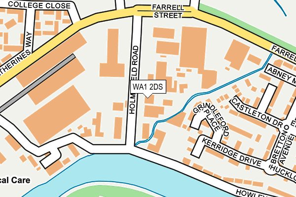
WA1 2DS is located in the Fairfield and Howley electoral ward, within the unitary authority of Warrington and the English Parliamentary constituency of Warrington North. The Sub Integrated Care Board (ICB) Location is NHS Cheshire and Merseyside ICB - 02E and the police force is Cheshire. This postcode has been in use since January 1980.


GetTheData
Source: OS OpenMap – Local (Ordnance Survey)
Source: OS VectorMap District (Ordnance Survey)
Licence: Open Government Licence (requires attribution)
| Easting | 361890 |
| Northing | 388296 |
| Latitude | 53.390117 |
| Longitude | -2.574499 |
GetTheData
Source: Open Postcode Geo
Licence: Open Government Licence
| Country | England |
| Postcode District | WA1 |
| ➜ WA1 open data dashboard ➜ See where WA1 is on a map ➜ Where is Warrington? | |
GetTheData
Source: Land Registry Price Paid Data
Licence: Open Government Licence
Elevation or altitude of WA1 2DS as distance above sea level:
| Metres | Feet | |
|---|---|---|
| Elevation | 10m | 33ft |
Elevation is measured from the approximate centre of the postcode, to the nearest point on an OS contour line from OS Terrain 50, which has contour spacing of ten vertical metres.
➜ How high above sea level am I? Find the elevation of your current position using your device's GPS.
GetTheData
Source: Open Postcode Elevation
Licence: Open Government Licence
| Ward | Fairfield And Howley |
| Constituency | Warrington North |
GetTheData
Source: ONS Postcode Database
Licence: Open Government Licence
| June 2022 | Shoplifting | On or near Pedestrian Subway | 178m |
| June 2022 | Violence and sexual offences | On or near Sports/Recreation Area | 294m |
| June 2022 | Public order | On or near College Close | 298m |
| ➜ Get more crime data in our Crime section | |||
GetTheData
Source: data.police.uk
Licence: Open Government Licence
| Parish Church (Church Street) | Howley | 461m |
| St Elphin's Park (Manchester Road) | Howley | 478m |
| Sainsburys (Church Street) | Howley | 490m |
| St Elphin's Park (Manchester Road) | Howley | 490m |
| Helsby Street (Manchester Road) | Howley | 589m |
| Warrington Central Station | 1.3km |
| Warrington Bank Quay Station | 1.9km |
| Padgate Station | 2.1km |
GetTheData
Source: NaPTAN
Licence: Open Government Licence
GetTheData
Source: ONS Postcode Database
Licence: Open Government Licence
➜ Get more ratings from the Food Standards Agency
GetTheData
Source: Food Standards Agency
Licence: FSA terms & conditions
| Last Collection | |||
|---|---|---|---|
| Location | Mon-Fri | Sat | Distance |
| Howley Lane | 16:45 | 11:00 | 387m |
| Manchester Road | 16:00 | 11:00 | 481m |
| Parr Street | 16:45 | 11:00 | 662m |
GetTheData
Source: Dracos
Licence: Creative Commons Attribution-ShareAlike
| Facility | Distance |
|---|---|
| St Elphins Ce Primary School Farrell Street, Warrington Grass Pitches | 298m |
| Victoria Park (Warrington) Knutsford Road, Latchford, Warrington Grass Pitches | 369m |
| St Elphins Park St. Katherines Way, Warrington Grass Pitches | 390m |
GetTheData
Source: Active Places
Licence: Open Government Licence
| School | Phase of Education | Distance |
|---|---|---|
| St Elphin's (Fairfield) CofE Voluntary Aided Primary School Farrell Street, Warrington, WA1 2GN | Primary | 314m |
| Cardinal Newman Catholic High School Bridgewater Avenue, Latchford, Warrington, WA4 1RX | Secondary | 883m |
| Oakwood Avenue Community Primary School Oakwood Avenue, Warrington, WA1 3SZ | Primary | 1km |
GetTheData
Source: Edubase
Licence: Open Government Licence
| Risk of WA1 2DS flooding from rivers and sea | Low |
| ➜ WA1 2DS flood map | |
GetTheData
Source: Open Flood Risk by Postcode
Licence: Open Government Licence
The below table lists the International Territorial Level (ITL) codes (formerly Nomenclature of Territorial Units for Statistics (NUTS) codes) and Local Administrative Units (LAU) codes for WA1 2DS:
| ITL 1 Code | Name |
|---|---|
| TLD | North West (England) |
| ITL 2 Code | Name |
| TLD6 | Cheshire |
| ITL 3 Code | Name |
| TLD61 | Warrington |
| LAU 1 Code | Name |
| E06000007 | Warrington |
GetTheData
Source: ONS Postcode Directory
Licence: Open Government Licence
The below table lists the Census Output Area (OA), Lower Layer Super Output Area (LSOA), and Middle Layer Super Output Area (MSOA) for WA1 2DS:
| Code | Name | |
|---|---|---|
| OA | E00062958 | |
| LSOA | E01012478 | Warrington 012A |
| MSOA | E02002601 | Warrington 012 |
GetTheData
Source: ONS Postcode Directory
Licence: Open Government Licence
| WA1 2GT | Grindleford Place | 132m |
| WA1 2DJ | Howley Lane | 150m |
| WA1 2GQ | Castleton Drive | 190m |
| WA1 2GW | Kerridge Drive | 191m |
| WA1 2GS | Glossop Close | 235m |
| WA1 2EP | St Katherines Way | 257m |
| WA1 2GJ | Abney Mews | 289m |
| WA1 2GP | Bretton Avenue | 303m |
| WA1 2ES | St Katherines Way | 313m |
| WA1 2EG | College Close | 344m |
GetTheData
Source: Open Postcode Geo; Land Registry Price Paid Data
Licence: Open Government Licence