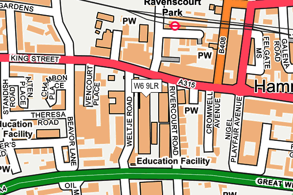
W6 9LR is located in the Ravenscourt electoral ward, within the London borough of Hammersmith and Fulham and the English Parliamentary constituency of Hammersmith. The Sub Integrated Care Board (ICB) Location is NHS North West London ICB - W2U3Z and the police force is Metropolitan Police. This postcode has been in use since January 1980.


GetTheData
Source: OS OpenMap – Local (Ordnance Survey)
Source: OS VectorMap District (Ordnance Survey)
Licence: Open Government Licence (requires attribution)
| Easting | 522484 |
| Northing | 178561 |
| Latitude | 51.492736 |
| Longitude | -0.237087 |
GetTheData
Source: Open Postcode Geo
Licence: Open Government Licence
| Country | England |
| Postcode District | W6 |
| ➜ W6 open data dashboard ➜ See where W6 is on a map ➜ Where is Hammersmith? | |
GetTheData
Source: Land Registry Price Paid Data
Licence: Open Government Licence
Elevation or altitude of W6 9LR as distance above sea level:
| Metres | Feet | |
|---|---|---|
| Elevation | 10m | 33ft |
Elevation is measured from the approximate centre of the postcode, to the nearest point on an OS contour line from OS Terrain 50, which has contour spacing of ten vertical metres.
➜ How high above sea level am I? Find the elevation of your current position using your device's GPS.
GetTheData
Source: Open Postcode Elevation
Licence: Open Government Licence
| Ward | Ravenscourt |
| Constituency | Hammersmith |
GetTheData
Source: ONS Postcode Database
Licence: Open Government Licence
| January 2024 | Burglary | On or near Ravenscourt Road | 294m |
| January 2024 | Drugs | On or near Ravenscourt Road | 294m |
| January 2024 | Robbery | On or near Galena Road | 308m |
| ➜ Get more crime data in our Crime section | |||
GetTheData
Source: data.police.uk
Licence: Open Government Licence
| Ravenscourt Park Station (King Street) | Ravenscourt Park | 59m |
| Ravenscourt Park Station | Ravenscourt Park | 89m |
| Dalling Road (King Street) | Ravenscourt Park | 131m |
| Ravenscourt Park (King Street) | Stamford Brook | 238m |
| Ravenscourt Park (King Street) | Stamford Brook | 245m |
| Ravenscourt Park Underground Station | Ravenscourt Park | 175m |
| Stamford Brook Underground Station | Stamford Brook | 646m |
| Hammersmith (H&c Line) Underground Station | Hammersmith | 843m |
| Hammersmith (Dist&picc Line) Underground Station | Hammersmith | 936m |
| Turnham Green Underground Station | Turnham Green | 1,242m |
| Shepherds Bush Station | 1.9km |
| Kensington (Olympia) Station | 1.9km |
| South Acton Station | 2.4km |
GetTheData
Source: NaPTAN
Licence: Open Government Licence
GetTheData
Source: ONS Postcode Database
Licence: Open Government Licence


➜ Get more ratings from the Food Standards Agency
GetTheData
Source: Food Standards Agency
Licence: FSA terms & conditions
| Last Collection | |||
|---|---|---|---|
| Location | Mon-Fri | Sat | Distance |
| Hammersmith Delivery Office | 18:30 | 12:00 | 140m |
| Post Office | 18:30 | 12:00 | 222m |
| Weltje Road | 17:30 | 12:00 | 257m |
GetTheData
Source: Dracos
Licence: Creative Commons Attribution-ShareAlike
| Facility | Distance |
|---|---|
| Latymer Upper School King Street, London Health and Fitness Gym, Sports Hall, Swimming Pool, Studio | 0m |
| State Of Mind Fitness Galena Road, London Health and Fitness Gym | 307m |
| West London Free School Primary Cambridge Grove, London Sports Hall | 513m |
GetTheData
Source: Active Places
Licence: Open Government Licence
| School | Phase of Education | Distance |
|---|---|---|
| Latymer Upper School 237 King Street, Hammersmith, London, W6 9LR | Not applicable | 42m |
| West London Free School 241 King Street, London, W6 9LP | Secondary | 58m |
| Ravenscourt Park Preparatory School 16 Ravenscourt Avenue, Ravenscourt Park, London, W6 0SL | Not applicable | 179m |
GetTheData
Source: Edubase
Licence: Open Government Licence
| Risk of W6 9LR flooding from rivers and sea | Very Low |
| ➜ W6 9LR flood map | |
GetTheData
Source: Open Flood Risk by Postcode
Licence: Open Government Licence
The below table lists the International Territorial Level (ITL) codes (formerly Nomenclature of Territorial Units for Statistics (NUTS) codes) and Local Administrative Units (LAU) codes for W6 9LR:
| ITL 1 Code | Name |
|---|---|
| TLI | London |
| ITL 2 Code | Name |
| TLI3 | Inner London - West |
| ITL 3 Code | Name |
| TLI33 | Kensington & Chelsea and Hammersmith & Fulham |
| LAU 1 Code | Name |
| E09000013 | Hammersmith and Fulham |
GetTheData
Source: ONS Postcode Directory
Licence: Open Government Licence
The below table lists the Census Output Area (OA), Lower Layer Super Output Area (LSOA), and Middle Layer Super Output Area (MSOA) for W6 9LR:
| Code | Name | |
|---|---|---|
| OA | E00009662 | |
| LSOA | E01001932 | Hammersmith and Fulham 011C |
| MSOA | E02000382 | Hammersmith and Fulham 011 |
GetTheData
Source: ONS Postcode Directory
Licence: Open Government Licence
| W6 9LP | King Street | 29m |
| W6 9LS | Weltje Road | 77m |
| W6 0RF | King Street | 79m |
| W6 9LD | Rivercourt Road | 99m |
| W6 0RA | King Street | 99m |
| W6 9LT | Weltje Road | 109m |
| W6 0SL | Ravenscourt Avenue | 123m |
| W6 0UH | Ravenscourt Road | 132m |
| W6 9LB | Cromwell Avenue | 136m |
| W6 9AR | Beavor Lane | 149m |
GetTheData
Source: Open Postcode Geo; Land Registry Price Paid Data
Licence: Open Government Licence