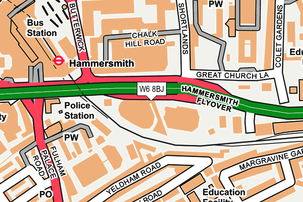
W6 8BJ is located in the Hammersmith Broadway electoral ward, within the London borough of Hammersmith and Fulham and the English Parliamentary constituency of Hammersmith. The Sub Integrated Care Board (ICB) Location is NHS North West London ICB - W2U3Z and the police force is Metropolitan Police. This postcode has been in use since September 1981.


GetTheData
Source: OS OpenMap – Local (Ordnance Survey)
Source: OS VectorMap District (Ordnance Survey)
Licence: Open Government Licence (requires attribution)
| Easting | 523655 |
| Northing | 178399 |
| Latitude | 51.491025 |
| Longitude | -0.220284 |
GetTheData
Source: Open Postcode Geo
Licence: Open Government Licence
| Country | England |
| Postcode District | W6 |
| ➜ W6 open data dashboard ➜ See where W6 is on a map ➜ Where is Hammersmith? | |
GetTheData
Source: Land Registry Price Paid Data
Licence: Open Government Licence
Elevation or altitude of W6 8BJ as distance above sea level:
| Metres | Feet | |
|---|---|---|
| Elevation | 10m | 33ft |
Elevation is measured from the approximate centre of the postcode, to the nearest point on an OS contour line from OS Terrain 50, which has contour spacing of ten vertical metres.
➜ How high above sea level am I? Find the elevation of your current position using your device's GPS.
GetTheData
Source: Open Postcode Elevation
Licence: Open Government Licence
| Ward | Hammersmith Broadway |
| Constituency | Hammersmith |
GetTheData
Source: ONS Postcode Database
Licence: Open Government Licence
| January 2024 | Robbery | On or near Black'S Road | 442m |
| January 2024 | Robbery | On or near Black'S Road | 442m |
| January 2024 | Anti-social behaviour | On or near Police Station | 490m |
| ➜ Get more crime data in our Crime section | |||
GetTheData
Source: data.police.uk
Licence: Open Government Licence
| Hammersmith Broadway (Fulham Palace Road) | Hammersmith | 217m |
| Hammersmith Bus Station | Hammersmith | 229m |
| Hammersmith Bus Station | Hammersmith | 232m |
| Hammersmith Bus Station | Hammersmith | 234m |
| Hammersmith Broadway (Hammersmith Road) | Hammersmith | 238m |
| Hammersmith (Dist&picc Line) Underground Station | Hammersmith | 272m |
| Hammersmith (H&c Line) Underground Station | Hammersmith | 431m |
| Barons Court Underground Station | Barons Court | 483m |
| West Kensington Underground Station | West Kensington | 950m |
| Kensington (Olympia) Underground Station | Olympia | 1,023m |
| Kensington (Olympia) Station | 1km |
| Shepherds Bush Station | 1.6km |
| West Brompton Station | 1.8km |
GetTheData
Source: NaPTAN
Licence: Open Government Licence
GetTheData
Source: ONS Postcode Database
Licence: Open Government Licence


➜ Get more ratings from the Food Standards Agency
GetTheData
Source: Food Standards Agency
Licence: FSA terms & conditions
| Last Collection | |||
|---|---|---|---|
| Location | Mon-Fri | Sat | Distance |
| Nazareth House (Convent) | 17:30 | 12:00 | 250m |
| Fulham Palace Road | 17:30 | 12:00 | 251m |
| Margravine Gardens | 17:30 | 12:00 | 281m |
GetTheData
Source: Dracos
Licence: Creative Commons Attribution-ShareAlike
| Facility | Distance |
|---|---|
| Hammersmith Fitness & Squash Centre Chalkhill Road, London Health and Fitness Gym, Studio, Squash Courts | 115m |
| Virgin Active (Hammersmith) (Closed) Hammersmith Road, London Swimming Pool, Health and Fitness Gym, Studio | 215m |
| Jetts Hammersmith Fulham Palace Road, London Health and Fitness Gym | 227m |
GetTheData
Source: Active Places
Licence: Open Government Licence
| School | Phase of Education | Distance |
|---|---|---|
| William Morris Sixth Form St Dunstan's Road, London, W6 8RB | 16 plus | 272m |
| Sacred Heart High School 212 Hammersmith Road, Hammersmith, London, W6 7DG | Secondary | 355m |
| Ealing, Hammersmith and West London College Gliddon Road, Barons Court, London, W14 9BL | 16 plus | 445m |
GetTheData
Source: Edubase
Licence: Open Government Licence
| Risk of W6 8BJ flooding from rivers and sea | Very Low |
| ➜ W6 8BJ flood map | |
GetTheData
Source: Open Flood Risk by Postcode
Licence: Open Government Licence
The below table lists the International Territorial Level (ITL) codes (formerly Nomenclature of Territorial Units for Statistics (NUTS) codes) and Local Administrative Units (LAU) codes for W6 8BJ:
| ITL 1 Code | Name |
|---|---|
| TLI | London |
| ITL 2 Code | Name |
| TLI3 | Inner London - West |
| ITL 3 Code | Name |
| TLI33 | Kensington & Chelsea and Hammersmith & Fulham |
| LAU 1 Code | Name |
| E09000013 | Hammersmith and Fulham |
GetTheData
Source: ONS Postcode Directory
Licence: Open Government Licence
The below table lists the Census Output Area (OA), Lower Layer Super Output Area (LSOA), and Middle Layer Super Output Area (MSOA) for W6 8BJ:
| Code | Name | |
|---|---|---|
| OA | E00009463 | |
| LSOA | E01001900 | Hammersmith and Fulham 013E |
| MSOA | E02000384 | Hammersmith and Fulham 013 |
GetTheData
Source: ONS Postcode Directory
Licence: Open Government Licence
| W6 8JQ | Yeldham Road | 126m |
| W6 8JJ | Yeldham Villas | 127m |
| W6 8JG | Yeldham Road | 137m |
| W6 8DJ | Shortlands | 144m |
| W6 8JF | Yeldham Road | 165m |
| W6 8RJ | Margravine Gardens | 194m |
| W6 8JW | Biscay Road | 196m |
| W6 8JE | Yeldham Road | 218m |
| W6 8JN | Biscay Road | 221m |
| W6 8DF | Talgarth Road | 227m |
GetTheData
Source: Open Postcode Geo; Land Registry Price Paid Data
Licence: Open Government Licence