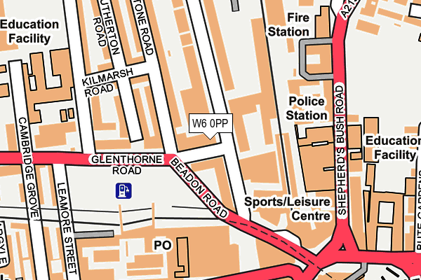
W6 0PP is located in the Grove electoral ward, within the London borough of Hammersmith and Fulham and the English Parliamentary constituency of Hammersmith. The Sub Integrated Care Board (ICB) Location is NHS North West London ICB - W2U3Z and the police force is Metropolitan Police. This postcode has been in use since December 1994.


GetTheData
Source: OS OpenMap – Local (Ordnance Survey)
Source: OS VectorMap District (Ordnance Survey)
Licence: Open Government Licence (requires attribution)
| Easting | 523205 |
| Northing | 178790 |
| Latitude | 51.494637 |
| Longitude | -0.226627 |
GetTheData
Source: Open Postcode Geo
Licence: Open Government Licence
| Country | England |
| Postcode District | W6 |
| ➜ W6 open data dashboard ➜ See where W6 is on a map ➜ Where is Hammersmith? | |
GetTheData
Source: Land Registry Price Paid Data
Licence: Open Government Licence
Elevation or altitude of W6 0PP as distance above sea level:
| Metres | Feet | |
|---|---|---|
| Elevation | 10m | 33ft |
Elevation is measured from the approximate centre of the postcode, to the nearest point on an OS contour line from OS Terrain 50, which has contour spacing of ten vertical metres.
➜ How high above sea level am I? Find the elevation of your current position using your device's GPS.
GetTheData
Source: Open Postcode Elevation
Licence: Open Government Licence
| Ward | Grove |
| Constituency | Hammersmith |
GetTheData
Source: ONS Postcode Database
Licence: Open Government Licence
| January 2024 | Anti-social behaviour | On or near Police Station | 158m |
| January 2024 | Anti-social behaviour | On or near Police Station | 158m |
| January 2024 | Anti-social behaviour | On or near Police Station | 158m |
| ➜ Get more crime data in our Crime section | |||
GetTheData
Source: data.police.uk
Licence: Open Government Licence
| Glenthorne House (Glenthorne Road) | Hammersmith | 16m |
| Hammersmith Grove | Hammersmith | 66m |
| Hammersmith (Ham & City Line) (Beadon Road) | Hammersmith | 121m |
| Hammersmith Library | Hammersmith | 212m |
| Hammersmith Library (Shepherd's Bush Road) | Hammersmith | 213m |
| Hammersmith (H&c Line) Underground Station | Hammersmith | 166m |
| Hammersmith (Dist&picc Line) Underground Station | Hammersmith | 334m |
| Ravenscourt Park Underground Station | Ravenscourt Park | 645m |
| Goldhawk Road Underground Station | Goldhawk Road | 819m |
| Barons Court Underground Station | Barons Court | 1,035m |
| Kensington (Olympia) Station | 1.2km |
| Shepherds Bush Station | 1.3km |
| West Brompton Station | 2.3km |
GetTheData
Source: NaPTAN
Licence: Open Government Licence
GetTheData
Source: ONS Postcode Database
Licence: Open Government Licence


➜ Get more ratings from the Food Standards Agency
GetTheData
Source: Food Standards Agency
Licence: FSA terms & conditions
| Last Collection | |||
|---|---|---|---|
| Location | Mon-Fri | Sat | Distance |
| Hammersmith P.o. | 17:30 | 12:00 | 162m |
| Hammersmith Broadway (L.u.l.) | 18:30 | 12:00 | 227m |
| Phoenix Lodge Mansions | 17:30 | 12:00 | 266m |
GetTheData
Source: Dracos
Licence: Creative Commons Attribution-ShareAlike
| Facility | Distance |
|---|---|
| Fitness First (Hammersmith) Hammersmith Grove, London Health and Fitness Gym, Studio, Swimming Pool | 48m |
| Puregym (London Hammersmith Palais) Shepherds Bush Road, London Health and Fitness Gym, Studio | 151m |
| The Godolphin And Latymer School Iffley Road, London Health and Fitness Gym, Sports Hall, Artificial Grass Pitch, Studio | 242m |
GetTheData
Source: Active Places
Licence: Open Government Licence
| School | Phase of Education | Distance |
|---|---|---|
| The Godolphin and Latymer School Iffley Road, Hammersmith, London, W6 0PG | Not applicable | 244m |
| Sacred Heart High School 212 Hammersmith Road, Hammersmith, London, W6 7DG | Secondary | 256m |
| West London Free School Primary Cambridge Grove, London, W6 0LB | Primary | 284m |
GetTheData
Source: Edubase
Licence: Open Government Licence
| Risk of W6 0PP flooding from rivers and sea | Very Low |
| ➜ W6 0PP flood map | |
GetTheData
Source: Open Flood Risk by Postcode
Licence: Open Government Licence
The below table lists the International Territorial Level (ITL) codes (formerly Nomenclature of Territorial Units for Statistics (NUTS) codes) and Local Administrative Units (LAU) codes for W6 0PP:
| ITL 1 Code | Name |
|---|---|
| TLI | London |
| ITL 2 Code | Name |
| TLI3 | Inner London - West |
| ITL 3 Code | Name |
| TLI33 | Kensington & Chelsea and Hammersmith & Fulham |
| LAU 1 Code | Name |
| E09000013 | Hammersmith and Fulham |
GetTheData
Source: ONS Postcode Directory
Licence: Open Government Licence
The below table lists the Census Output Area (OA), Lower Layer Super Output Area (LSOA), and Middle Layer Super Output Area (MSOA) for W6 0PP:
| Code | Name | |
|---|---|---|
| OA | E00009485 | |
| LSOA | E01001898 | Hammersmith and Fulham 013C |
| MSOA | E02000384 | Hammersmith and Fulham 013 |
GetTheData
Source: ONS Postcode Directory
Licence: Open Government Licence
| W6 0AA | Overstone Road | 78m |
| W6 0BT | Beadon Road | 88m |
| W6 7HA | Hammersmith Grove | 115m |
| W6 0EW | Glenthorne Road | 128m |
| W6 0LS | Glenthorne Road | 139m |
| W6 7NJ | Shepherds Bush Road | 160m |
| W6 0PL | Kilmarsh Road | 162m |
| W6 0EA | Beadon Road | 168m |
| W6 0PH | Southerton Road | 178m |
| W6 0YH | King Street | 182m |
GetTheData
Source: Open Postcode Geo; Land Registry Price Paid Data
Licence: Open Government Licence