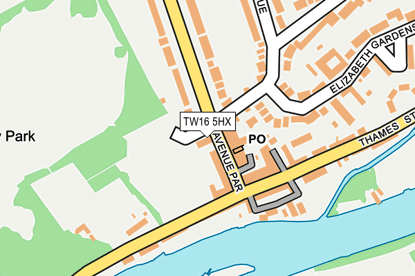
TW16 5HX is located in the Sunbury East electoral ward, within the local authority district of Spelthorne and the English Parliamentary constituency of Spelthorne. The Sub Integrated Care Board (ICB) Location is NHS Surrey Heartlands ICB - 92A and the police force is Surrey. This postcode has been in use since January 1993.


GetTheData
Source: OS OpenMap – Local (Ordnance Survey)
Source: OS VectorMap District (Ordnance Survey)
Licence: Open Government Licence (requires attribution)
| Easting | 510923 |
| Northing | 168765 |
| Latitude | 51.407073 |
| Longitude | -0.406611 |
GetTheData
Source: Open Postcode Geo
Licence: Open Government Licence
| Country | England |
| Postcode District | TW16 |
| ➜ TW16 open data dashboard ➜ See where TW16 is on a map ➜ Where is Sunbury-on-Thames? | |
GetTheData
Source: Land Registry Price Paid Data
Licence: Open Government Licence
Elevation or altitude of TW16 5HX as distance above sea level:
| Metres | Feet | |
|---|---|---|
| Elevation | 10m | 33ft |
Elevation is measured from the approximate centre of the postcode, to the nearest point on an OS contour line from OS Terrain 50, which has contour spacing of ten vertical metres.
➜ How high above sea level am I? Find the elevation of your current position using your device's GPS.
GetTheData
Source: Open Postcode Elevation
Licence: Open Government Licence
| Ward | Sunbury East |
| Constituency | Spelthorne |
GetTheData
Source: ONS Postcode Database
Licence: Open Government Licence
| January 2024 | Criminal damage and arson | On or near Parking Area | 75m |
| January 2024 | Public order | On or near Church Street | 429m |
| December 2023 | Other theft | On or near Church Street | 429m |
| ➜ Get more crime data in our Crime section | |||
GetTheData
Source: data.police.uk
Licence: Open Government Licence
| Orchard Meadow (Thames Street) | Sunbury | 102m |
| Orchard Meadow (Thames Street) | Sunbury | 126m |
| French Street (Lower Hampton Road) | Sunbury | 327m |
| St Marys Church (Thames Street) | Sunbury | 335m |
| French Street (Lower Hampton Road) | Sunbury | 384m |
| Sunbury Station | 1.5km |
| Kempton Park Station | 1.6km |
| Upper Halliford Station | 1.8km |
GetTheData
Source: NaPTAN
Licence: Open Government Licence
GetTheData
Source: ONS Postcode Database
Licence: Open Government Licence


➜ Get more ratings from the Food Standards Agency
GetTheData
Source: Food Standards Agency
Licence: FSA terms & conditions
| Last Collection | |||
|---|---|---|---|
| Location | Mon-Fri | Sat | Distance |
| Post Office, 5 The Avenue Pde | 17:30 | 11:45 | 36m |
| Saxonbury Avenue | 17:30 | 11:45 | 194m |
| Darby Crescent | 17:30 | 11:30 | 511m |
GetTheData
Source: Dracos
Licence: Creative Commons Attribution-ShareAlike
| Facility | Distance |
|---|---|
| Elmbridge Xcel Sports Hub Waterside Drive, Walton-on-thames Grass Pitches, Artificial Grass Pitch, Athletics | 889m |
| St Pauls Catholic College (Sunbury) Manor Lane, Sunbury On Thames Grass Pitches, Sports Hall, Artificial Grass Pitch | 933m |
| Hazelwood Centre (London Irish Training Ground) Hazelwood Drive, Sunbury-on-thames Artificial Grass Pitch, Grass Pitches, Health and Fitness Gym | 947m |
GetTheData
Source: Active Places
Licence: Open Government Licence
| School | Phase of Education | Distance |
|---|---|---|
| Beauclerc Infant and Nursery School 116 French Street, Sunbury-on-Thames, TW16 5LE | Primary | 445m |
| Chennestone Primary School Manor Lane, Sunbury-on-Thames, TW16 5ED | Primary | 553m |
| Hawkedale Primary School Stratton Road, Sunbury on Thames, TW16 6PG | Primary | 967m |
GetTheData
Source: Edubase
Licence: Open Government Licence
| Risk of TW16 5HX flooding from rivers and sea | Low |
| ➜ TW16 5HX flood map | |
GetTheData
Source: Open Flood Risk by Postcode
Licence: Open Government Licence
The below table lists the International Territorial Level (ITL) codes (formerly Nomenclature of Territorial Units for Statistics (NUTS) codes) and Local Administrative Units (LAU) codes for TW16 5HX:
| ITL 1 Code | Name |
|---|---|
| TLJ | South East (England) |
| ITL 2 Code | Name |
| TLJ2 | Surrey, East and West Sussex |
| ITL 3 Code | Name |
| TLJ25 | West Surrey |
| LAU 1 Code | Name |
| E07000213 | Spelthorne |
GetTheData
Source: ONS Postcode Directory
Licence: Open Government Licence
The below table lists the Census Output Area (OA), Lower Layer Super Output Area (LSOA), and Middle Layer Super Output Area (MSOA) for TW16 5HX:
| Code | Name | |
|---|---|---|
| OA | E00156847 | |
| LSOA | E01030753 | Spelthorne 010A |
| MSOA | E02006412 | Spelthorne 010 |
GetTheData
Source: ONS Postcode Directory
Licence: Open Government Licence
| TW16 5HT | The Avenue | 28m |
| TW16 5HS | Avenue Parade | 41m |
| TW16 6AD | Thames Street | 80m |
| TW16 5QS | Thames Street | 113m |
| TW16 6AF | Thames Street | 124m |
| TW16 5QP | Thames Street | 143m |
| TW16 5QF | Berkeley Mews | 157m |
| TW16 5HP | Saxonbury Avenue | 161m |
| TW16 6AB | Thames Street | 173m |
| TW16 5HR | Rope Walk | 180m |
GetTheData
Source: Open Postcode Geo; Land Registry Price Paid Data
Licence: Open Government Licence