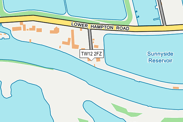
TW12 2FZ is located in the Sunbury East electoral ward, within the local authority district of Spelthorne and the English Parliamentary constituency of Spelthorne. The Sub Integrated Care Board (ICB) Location is NHS Surrey Heartlands ICB - 92A and the police force is Surrey. This postcode has been in use since December 2010.


GetTheData
Source: OS OpenMap – Local (Ordnance Survey)
Source: OS VectorMap District (Ordnance Survey)
Licence: Open Government Licence (requires attribution)
| Easting | 512504 |
| Northing | 169019 |
| Latitude | 51.409044 |
| Longitude | -0.383809 |
GetTheData
Source: Open Postcode Geo
Licence: Open Government Licence
| Country | England |
| Postcode District | TW12 |
| ➜ TW12 open data dashboard ➜ See where TW12 is on a map ➜ Where is Sunbury-on-Thames? | |
GetTheData
Source: Land Registry Price Paid Data
Licence: Open Government Licence
Elevation or altitude of TW12 2FZ as distance above sea level:
| Metres | Feet | |
|---|---|---|
| Elevation | 10m | 33ft |
Elevation is measured from the approximate centre of the postcode, to the nearest point on an OS contour line from OS Terrain 50, which has contour spacing of ten vertical metres.
➜ How high above sea level am I? Find the elevation of your current position using your device's GPS.
GetTheData
Source: Open Postcode Elevation
Licence: Open Government Licence
| Ward | Sunbury East |
| Constituency | Spelthorne |
GetTheData
Source: ONS Postcode Database
Licence: Open Government Licence
| April 2022 | Burglary | On or near Cherry Orchard Gardens | 482m |
| October 2021 | Anti-social behaviour | On or near Cherry Orchard Gardens | 482m |
| August 2021 | Public order | On or near Cherry Orchard Gardens | 482m |
| ➜ Get more crime data in our Crime section | |||
GetTheData
Source: data.police.uk
Licence: Open Government Licence
| Stain Hill Reservoir | Hampton | 549m |
| Hampton Care Nursing Home | Hampton | 616m |
| Hampton Care Nursing Home | Hampton | 651m |
| Lower Hampton Road (Harfield Road) | Sunbury | 735m |
| Lower Hampton Road (Harfield Road) | Sunbury | 748m |
| Hampton (London) Station | 1.1km |
| Kempton Park Station | 2.2km |
| Sunbury Station | 2.6km |
GetTheData
Source: NaPTAN
Licence: Open Government Licence
GetTheData
Source: ONS Postcode Database
Licence: Open Government Licence

➜ Get more ratings from the Food Standards Agency
GetTheData
Source: Food Standards Agency
Licence: FSA terms & conditions
| Last Collection | |||
|---|---|---|---|
| Location | Mon-Fri | Sat | Distance |
| Bishop Fox Estate | 17:00 | 12:15 | 583m |
| Kenton Avenue | 17:30 | 11:30 | 591m |
| Cherry Orchard | 17:00 | 12:15 | 673m |
GetTheData
Source: Dracos
Licence: Creative Commons Attribution-ShareAlike
| Facility | Distance |
|---|---|
| Hurst Park Primary School Hurst Road, West Molesey Grass Pitches | 586m |
| Sunbury Sports Association Lower Hampton Road, Sunbury-on-thames Health and Fitness Gym, Squash Courts, Grass Pitches | 658m |
| St Mary's Hampton Ce Primary School Oldfield Road, Hampton Grass Pitches | 687m |
GetTheData
Source: Active Places
Licence: Open Government Licence
| School | Phase of Education | Distance |
|---|---|---|
| Hurst Park Primary Academy Hurst Road, West Molesey, KT8 1QS | Primary | 761m |
| The Beech House School 413 Walton Road, West Molesey, KT8 2EJ | Not applicable | 841m |
| St Mary's Hampton Church of England Primary Oldfield Road, Hampton, TW12 2HP | Primary | 864m |
GetTheData
Source: Edubase
Licence: Open Government Licence
| Risk of TW12 2FZ flooding from rivers and sea | High |
| ➜ TW12 2FZ flood map | |
GetTheData
Source: Open Flood Risk by Postcode
Licence: Open Government Licence
The below table lists the International Territorial Level (ITL) codes (formerly Nomenclature of Territorial Units for Statistics (NUTS) codes) and Local Administrative Units (LAU) codes for TW12 2FZ:
| ITL 1 Code | Name |
|---|---|
| TLJ | South East (England) |
| ITL 2 Code | Name |
| TLJ2 | Surrey, East and West Sussex |
| ITL 3 Code | Name |
| TLJ25 | West Surrey |
| LAU 1 Code | Name |
| E07000213 | Spelthorne |
GetTheData
Source: ONS Postcode Directory
Licence: Open Government Licence
The below table lists the Census Output Area (OA), Lower Layer Super Output Area (LSOA), and Middle Layer Super Output Area (MSOA) for TW12 2FZ:
| Code | Name | |
|---|---|---|
| OA | E00156831 | |
| LSOA | E01030756 | Spelthorne 010D |
| MSOA | E02006412 | Spelthorne 010 |
GetTheData
Source: ONS Postcode Directory
Licence: Open Government Licence
| TW16 5PR | Lower Hampton Road | 277m |
| KT8 2TL | Augusta Close | 474m |
| KT8 1RF | Hurst Road | 479m |
| KT8 1QY | Cherry Orchard Gardens | 504m |
| KT8 2TJ | Lytcott Drive | 519m |
| KT8 2TW | Hollingworth Close | 551m |
| KT8 1QX | River Bank | 568m |
| TW16 5AS | Kenton Avenue | 583m |
| KT8 1QZ | Cherry Orchard Road | 596m |
| KT8 1QS | Hurst Road | 598m |
GetTheData
Source: Open Postcode Geo; Land Registry Price Paid Data
Licence: Open Government Licence