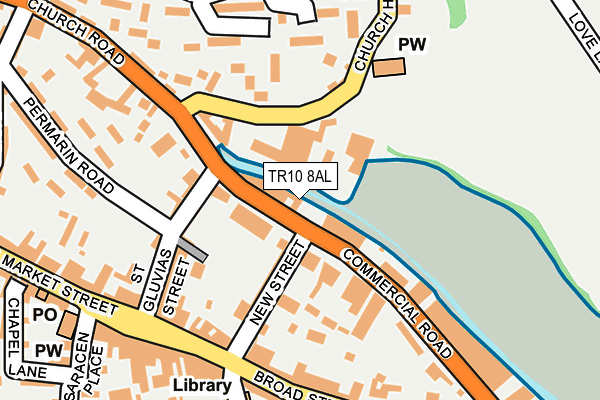
TR10 8AL is located in the Penryn electoral ward, within the unitary authority of Cornwall and the English Parliamentary constituency of Truro and Falmouth. The Sub Integrated Care Board (ICB) Location is NHS Cornwall and the Isles of Scilly ICB - 11N and the police force is Devon & Cornwall. This postcode has been in use since December 1997.


GetTheData
Source: OS OpenMap – Local (Ordnance Survey)
Source: OS VectorMap District (Ordnance Survey)
Licence: Open Government Licence (requires attribution)
| Easting | 178654 |
| Northing | 34526 |
| Latitude | 50.169341 |
| Longitude | -5.100958 |
GetTheData
Source: Open Postcode Geo
Licence: Open Government Licence
| Country | England |
| Postcode District | TR10 |
| ➜ TR10 open data dashboard ➜ See where TR10 is on a map ➜ Where is Penryn? | |
GetTheData
Source: Land Registry Price Paid Data
Licence: Open Government Licence
Elevation or altitude of TR10 8AL as distance above sea level:
| Metres | Feet | |
|---|---|---|
| Elevation | 10m | 33ft |
Elevation is measured from the approximate centre of the postcode, to the nearest point on an OS contour line from OS Terrain 50, which has contour spacing of ten vertical metres.
➜ How high above sea level am I? Find the elevation of your current position using your device's GPS.
GetTheData
Source: Open Postcode Elevation
Licence: Open Government Licence
| Ward | Penryn |
| Constituency | Truro And Falmouth |
GetTheData
Source: ONS Postcode Database
Licence: Open Government Licence
| October 2022 | Violence and sexual offences | On or near New Street | 101m |
| October 2022 | Violence and sexual offences | On or near New Street | 101m |
| October 2022 | Violence and sexual offences | On or near Bohelland Road | 198m |
| ➜ Get more crime data in our Crime section | |||
GetTheData
Source: data.police.uk
Licence: Open Government Licence
| Kessells | Penryn | 118m |
| Kessells (Commercial Road) | Penryn | 121m |
| Kings Arms (Broad Street) | Penryn | 183m |
| Costcutter (Lower Market Street) | Penryn | 246m |
| Bowling Club | Penryn | 250m |
| Penryn Station | 0.8km |
| Penmere Station | 2.5km |
| Falmouth Town Station | 3.5km |
GetTheData
Source: NaPTAN
Licence: Open Government Licence
GetTheData
Source: ONS Postcode Database
Licence: Open Government Licence


➜ Get more ratings from the Food Standards Agency
GetTheData
Source: Food Standards Agency
Licence: FSA terms & conditions
| Last Collection | |||
|---|---|---|---|
| Location | Mon-Fri | Sat | Distance |
| Penryn Post Office | 17:15 | 11:00 | 276m |
| Helston Road | 16:45 | 11:00 | 627m |
| Truro Hill | 16:40 | 11:15 | 635m |
GetTheData
Source: Dracos
Licence: Creative Commons Attribution-ShareAlike
| Facility | Distance |
|---|---|
| Penryn Primary Academy Treverbyn Rise, Penryn Swimming Pool, Sports Hall | 1km |
| Penryn College Kernick Road, Penryn Health and Fitness Gym, Sports Hall, Artificial Grass Pitch, Grass Pitches, Indoor Tennis Centre, Studio, Outdoor Tennis Courts | 1km |
| Falmouth Cricket Club Trescobeas Road, Falmouth Grass Pitches | 1.1km |
GetTheData
Source: Active Places
Licence: Open Government Licence
| School | Phase of Education | Distance |
|---|---|---|
| Penryn Primary Academy Treverbyn Rise, Penryn, TR10 8RA | Primary | 1km |
| Penryn College Kernick Road, Penryn, TR10 8PZ | Secondary | 1.1km |
| Falmouth School Trescobeas Road, Falmouth, TR11 4LH | Secondary | 1.3km |
GetTheData
Source: Edubase
Licence: Open Government Licence
| Risk of TR10 8AL flooding from rivers and sea | High |
| ➜ TR10 8AL flood map | |
GetTheData
Source: Open Flood Risk by Postcode
Licence: Open Government Licence
The below table lists the International Territorial Level (ITL) codes (formerly Nomenclature of Territorial Units for Statistics (NUTS) codes) and Local Administrative Units (LAU) codes for TR10 8AL:
| ITL 1 Code | Name |
|---|---|
| TLK | South West (England) |
| ITL 2 Code | Name |
| TLK3 | Cornwall and Isles of Scilly |
| ITL 3 Code | Name |
| TLK30 | Cornwall and Isles of Scilly |
| LAU 1 Code | Name |
| E06000052 | Cornwall |
GetTheData
Source: ONS Postcode Directory
Licence: Open Government Licence
The below table lists the Census Output Area (OA), Lower Layer Super Output Area (LSOA), and Middle Layer Super Output Area (MSOA) for TR10 8AL:
| Code | Name | |
|---|---|---|
| OA | E00095087 | |
| LSOA | E01018837 | Cornwall 060D |
| MSOA | E02003914 | Cornwall 060 |
GetTheData
Source: ONS Postcode Directory
Licence: Open Government Licence
| TR10 8AQ | Commercial Road | 59m |
| TR10 8BJ | St Gluvias Street | 109m |
| TR10 8EB | New Street | 117m |
| TR10 8AG | Commercial Road | 128m |
| TR10 8AJ | Church Hill | 128m |
| TR10 8BL | St Gluvias Street | 155m |
| TR10 8BY | Church Road | 163m |
| TR10 8JJ | The Retreat | 167m |
| TR10 8BG | Lower Market Street | 176m |
| TR10 8DY | Bohelland Road | 180m |
GetTheData
Source: Open Postcode Geo; Land Registry Price Paid Data
Licence: Open Government Licence