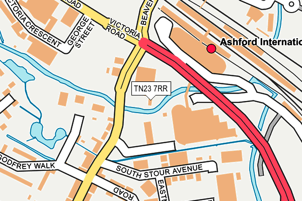
TN23 7RR is located in the Victoria electoral ward, within the local authority district of Ashford and the English Parliamentary constituency of Ashford. The Sub Integrated Care Board (ICB) Location is NHS Kent and Medway ICB - 91Q and the police force is Kent. This postcode has been in use since December 1994.


GetTheData
Source: OS OpenMap – Local (Ordnance Survey)
Source: OS VectorMap District (Ordnance Survey)
Licence: Open Government Licence (requires attribution)
| Easting | 601077 |
| Northing | 141969 |
| Latitude | 51.141665 |
| Longitude | 0.873171 |
GetTheData
Source: Open Postcode Geo
Licence: Open Government Licence
| Country | England |
| Postcode District | TN23 |
| ➜ TN23 open data dashboard ➜ See where TN23 is on a map ➜ Where is Ashford? | |
GetTheData
Source: Land Registry Price Paid Data
Licence: Open Government Licence
Elevation or altitude of TN23 7RR as distance above sea level:
| Metres | Feet | |
|---|---|---|
| Elevation | 40m | 131ft |
Elevation is measured from the approximate centre of the postcode, to the nearest point on an OS contour line from OS Terrain 50, which has contour spacing of ten vertical metres.
➜ How high above sea level am I? Find the elevation of your current position using your device's GPS.
GetTheData
Source: Open Postcode Elevation
Licence: Open Government Licence
| Ward | Victoria |
| Constituency | Ashford |
GetTheData
Source: ONS Postcode Database
Licence: Open Government Licence
| December 2023 | Violence and sexual offences | On or near Parking Area | 477m |
| December 2023 | Criminal damage and arson | On or near Parking Area | 477m |
| December 2023 | Anti-social behaviour | On or near Parking Area | 477m |
| ➜ Get more crime data in our Crime section | |||
GetTheData
Source: data.police.uk
Licence: Open Government Licence
| Christchurch Road (Beaver Road) | South Ashford | 238m |
| Beaver Road Bridge (Beaver Road) | Ashford | 269m |
| Beaver Road Bridge (Beaver Road) | Ashford | 297m |
| Christchurch Road (Beaver Road) | South Ashford | 310m |
| Ashford International Railway Station (Station Approach) | Ashford | 320m |
| Ashford International Station | 0.3km |
| Wye Station | 6.2km |
GetTheData
Source: NaPTAN
Licence: Open Government Licence
GetTheData
Source: ONS Postcode Database
Licence: Open Government Licence


➜ Get more ratings from the Food Standards Agency
GetTheData
Source: Food Standards Agency
Licence: FSA terms & conditions
| Last Collection | |||
|---|---|---|---|
| Location | Mon-Fri | Sat | Distance |
| South Ashford Post Office | 18:30 | 12:30 | 266m |
| Ashford Station | 18:30 | 12:00 | 335m |
| Christchurch Road | 17:15 | 12:30 | 523m |
GetTheData
Source: Dracos
Licence: Creative Commons Attribution-ShareAlike
| Facility | Distance |
|---|---|
| The Elwick Club Church Road, Ashford Health and Fitness Gym, Squash Courts | 512m |
| Stour Centre Station Approach, Ashford Sports Hall, Swimming Pool, Health and Fitness Gym, Squash Courts, Studio | 596m |
| Snap Fitness (Ashford) Elwick Road, Ashford Health and Fitness Gym | 655m |
GetTheData
Source: Active Places
Licence: Open Government Licence
| School | Phase of Education | Distance |
|---|---|---|
| Victoria Road Primary School Victoria Road, Ashford, TN23 7HQ | Primary | 463m |
| The T3 School Sydenham house, Church road, TN23 1RD | Not applicable | 546m |
| The North School Essella Road, Ashford, TN24 8AL | Secondary | 921m |
GetTheData
Source: Edubase
Licence: Open Government Licence
| Risk of TN23 7RR flooding from rivers and sea | Low |
| ➜ TN23 7RR flood map | |
GetTheData
Source: Open Flood Risk by Postcode
Licence: Open Government Licence
The below table lists the International Territorial Level (ITL) codes (formerly Nomenclature of Territorial Units for Statistics (NUTS) codes) and Local Administrative Units (LAU) codes for TN23 7RR:
| ITL 1 Code | Name |
|---|---|
| TLJ | South East (England) |
| ITL 2 Code | Name |
| TLJ4 | Kent |
| ITL 3 Code | Name |
| TLJ45 | Mid Kent |
| LAU 1 Code | Name |
| E07000105 | Ashford |
GetTheData
Source: ONS Postcode Directory
Licence: Open Government Licence
The below table lists the Census Output Area (OA), Lower Layer Super Output Area (LSOA), and Middle Layer Super Output Area (MSOA) for TN23 7RR:
| Code | Name | |
|---|---|---|
| OA | E00121985 | |
| LSOA | E01024027 | Ashford 005D |
| MSOA | E02005000 | Ashford 005 |
GetTheData
Source: ONS Postcode Directory
Licence: Open Government Licence
| TN23 7RX | Eastmead Trading Estate | 105m |
| TN23 7RS | South Stour Avenue | 106m |
| TN23 7RP | Beaver Road | 107m |
| TN23 7SU | Lower Denmark Road | 121m |
| TN23 7SD | Beaver Road | 125m |
| TN23 7SZ | Denmark Terrace | 181m |
| TN23 7SB | Eastmead Avenue | 181m |
| TN23 7SY | Lower Denmark Road | 201m |
| TN23 7XH | Godfrey Walk | 206m |
| TN23 7SE | Beaver Road | 218m |
GetTheData
Source: Open Postcode Geo; Land Registry Price Paid Data
Licence: Open Government Licence