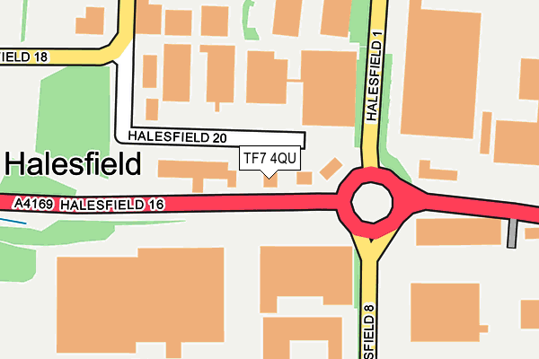
TF7 4QU lies on Halesfield 20 in Telford. TF7 4QU is located in the Madeley & Sutton Hill electoral ward, within the unitary authority of Telford and Wrekin and the English Parliamentary constituency of Telford. The Sub Integrated Care Board (ICB) Location is NHS Shropshire, Telford and Wrekin ICB - M2L0M and the police force is West Mercia. This postcode has been in use since January 1992.


GetTheData
Source: OS OpenMap – Local (Ordnance Survey)
Source: OS VectorMap District (Ordnance Survey)
Licence: Open Government Licence (requires attribution)
| Easting | 371228 |
| Northing | 304812 |
| Latitude | 52.640297 |
| Longitude | -2.426623 |
GetTheData
Source: Open Postcode Geo
Licence: Open Government Licence
| Street | Halesfield 20 |
| Town/City | Telford |
| Country | England |
| Postcode District | TF7 |
| ➜ TF7 open data dashboard ➜ See where TF7 is on a map ➜ Where is Telford? | |
GetTheData
Source: Land Registry Price Paid Data
Licence: Open Government Licence
Elevation or altitude of TF7 4QU as distance above sea level:
| Metres | Feet | |
|---|---|---|
| Elevation | 110m | 361ft |
Elevation is measured from the approximate centre of the postcode, to the nearest point on an OS contour line from OS Terrain 50, which has contour spacing of ten vertical metres.
➜ How high above sea level am I? Find the elevation of your current position using your device's GPS.
GetTheData
Source: Open Postcode Elevation
Licence: Open Government Licence
| Ward | Madeley & Sutton Hill |
| Constituency | Telford |
GetTheData
Source: ONS Postcode Database
Licence: Open Government Licence
| January 2024 | Vehicle crime | On or near Halesfield 17 | 448m |
| November 2023 | Other theft | On or near Halesfield 17 | 448m |
| September 2023 | Vehicle crime | On or near Halesfield 17 | 448m |
| ➜ Get more crime data in our Crime section | |||
GetTheData
Source: data.police.uk
Licence: Open Government Licence
| Garage (Kemberton Road) | Halesfield | 68m |
| Garage (Kemberton Road) | Halesfield | 91m |
| Johnston Controls (Haldane) | Halesfield | 265m |
| Johnson Controls (Haldane) | Halesfield | 301m |
| Clews Wood Roundabout (Haldane) | Halesfield | 547m |
| Telford Central Station | 4.6km |
| Shifnal Station | 4.7km |
GetTheData
Source: NaPTAN
Licence: Open Government Licence
| Median download speed | 19.4Mbps |
| Average download speed | 34.2Mbps |
| Maximum download speed | 80.00Mbps |
| Median upload speed | 1.2Mbps |
| Average upload speed | 7.1Mbps |
| Maximum upload speed | 20.00Mbps |
GetTheData
Source: Ofcom
Licence: Ofcom Terms of Use (requires attribution)
GetTheData
Source: ONS Postcode Database
Licence: Open Government Licence


➜ Get more ratings from the Food Standards Agency
GetTheData
Source: Food Standards Agency
Licence: FSA terms & conditions
| Last Collection | |||
|---|---|---|---|
| Location | Mon-Fri | Sat | Distance |
| Hills Lane | 16:45 | 10:45 | 905m |
| Tweedale Industrial Estate | 18:15 | 12:00 | 1,050m |
| High Street | 16:45 | 11:00 | 1,326m |
GetTheData
Source: Dracos
Licence: Creative Commons Attribution-ShareAlike
| Facility | Distance |
|---|---|
| John Randall Primary School Queen Street, Queen Street, Madeley, Telford Grass Pitches | 841m |
| Hills Lane Queens Court, Madeley, Telford Grass Pitches | 1km |
| Sutton Hill Playing Field Sutton Way, Sutton Hill, Telford Grass Pitches | 1.3km |
GetTheData
Source: Active Places
Licence: Open Government Licence
| School | Phase of Education | Distance |
|---|---|---|
| John Randall Primary School Queen Street, Madeley, Telford, TF7 4DS | Primary | 839m |
| Haughton School Queen Street, Madeley, Telford, TF7 4BW | Not applicable | 873m |
| Holmer Lake Primary School Brookside, Telford, TF3 1LD | Primary | 1.2km |
GetTheData
Source: Edubase
Licence: Open Government Licence
The below table lists the International Territorial Level (ITL) codes (formerly Nomenclature of Territorial Units for Statistics (NUTS) codes) and Local Administrative Units (LAU) codes for TF7 4QU:
| ITL 1 Code | Name |
|---|---|
| TLG | West Midlands (England) |
| ITL 2 Code | Name |
| TLG2 | Shropshire and Staffordshire |
| ITL 3 Code | Name |
| TLG21 | Telford and Wrekin |
| LAU 1 Code | Name |
| E06000020 | Telford and Wrekin |
GetTheData
Source: ONS Postcode Directory
Licence: Open Government Licence
The below table lists the Census Output Area (OA), Lower Layer Super Output Area (LSOA), and Middle Layer Super Output Area (MSOA) for TF7 4QU:
| Code | Name | |
|---|---|---|
| OA | E00173117 | |
| LSOA | E01014116 | Telford and Wrekin 023B |
| MSOA | E02002950 | Telford and Wrekin 023 |
GetTheData
Source: ONS Postcode Directory
Licence: Open Government Licence
| TF7 4QS | Kemberton Road | 33m |
| TF7 4NX | Halesfield 21 | 243m |
| TF7 4NA | Halesfield 7 | 365m |
| TF7 4QW | Halesfield 9 | 646m |
| TF7 4QH | Halesfield 2 | 672m |
| TF7 4HT | Cuckoo Oak Green | 702m |
| TF7 4QP | Halesfield 10 | 722m |
| TF7 4QR | Halesfield 14 | 747m |
| TF7 4QX | Halesfield 22 | 773m |
| TF7 4EN | Kemberton Drive | 778m |
GetTheData
Source: Open Postcode Geo; Land Registry Price Paid Data
Licence: Open Government Licence