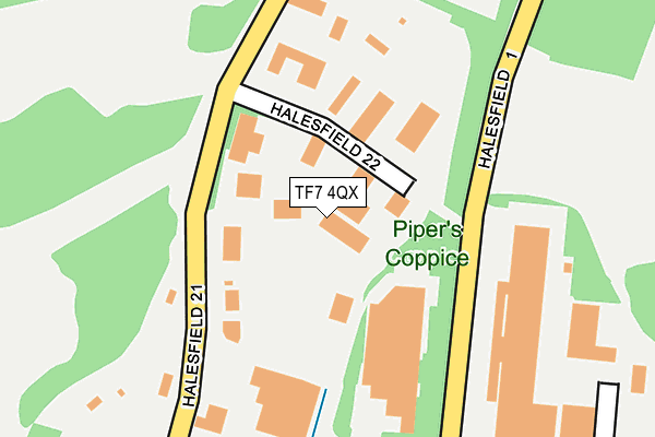
TF7 4QX lies on Halesfield 22 in Telford. TF7 4QX is located in the Madeley & Sutton Hill electoral ward, within the unitary authority of Telford and Wrekin and the English Parliamentary constituency of Telford. The Sub Integrated Care Board (ICB) Location is NHS Shropshire, Telford and Wrekin ICB - M2L0M and the police force is West Mercia. This postcode has been in use since January 1992.


GetTheData
Source: OS OpenMap – Local (Ordnance Survey)
Source: OS VectorMap District (Ordnance Survey)
Licence: Open Government Licence (requires attribution)
| Easting | 371366 |
| Northing | 305573 |
| Latitude | 52.647145 |
| Longitude | -2.424650 |
GetTheData
Source: Open Postcode Geo
Licence: Open Government Licence
| Street | Halesfield 22 |
| Town/City | Telford |
| Country | England |
| Postcode District | TF7 |
➜ See where TF7 is on a map ➜ Where is Telford? | |
GetTheData
Source: Land Registry Price Paid Data
Licence: Open Government Licence
Elevation or altitude of TF7 4QX as distance above sea level:
| Metres | Feet | |
|---|---|---|
| Elevation | 110m | 361ft |
Elevation is measured from the approximate centre of the postcode, to the nearest point on an OS contour line from OS Terrain 50, which has contour spacing of ten vertical metres.
➜ How high above sea level am I? Find the elevation of your current position using your device's GPS.
GetTheData
Source: Open Postcode Elevation
Licence: Open Government Licence
| Ward | Madeley & Sutton Hill |
| Constituency | Telford |
GetTheData
Source: ONS Postcode Database
Licence: Open Government Licence
| Garage (Kemberton Road) | Halesfield | 809m |
| Garage (Kemberton Road) | Halesfield | 834m |
| Holmer Lake (Holmer Farm Road) | Stirchley | 875m |
| Holmer Lake (Holmer Farm Road) | Stirchley | 884m |
| Lake End Dr (Brookside Avenue) | Brookside | 907m |
| Telford Central Station | 3.9km |
| Shifnal Station | 4.1km |
GetTheData
Source: NaPTAN
Licence: Open Government Licence
GetTheData
Source: ONS Postcode Database
Licence: Open Government Licence


➜ Get more ratings from the Food Standards Agency
GetTheData
Source: Food Standards Agency
Licence: FSA terms & conditions
| Last Collection | |||
|---|---|---|---|
| Location | Mon-Fri | Sat | Distance |
| Holmer Lake | 16:00 | 12:30 | 845m |
| Halesfield 18 Meter Box | 18:00 | 1,216m | |
| Brookside Post Office | 17:15 | 12:30 | 1,219m |
GetTheData
Source: Dracos
Licence: Creative Commons Attribution-ShareAlike
The below table lists the International Territorial Level (ITL) codes (formerly Nomenclature of Territorial Units for Statistics (NUTS) codes) and Local Administrative Units (LAU) codes for TF7 4QX:
| ITL 1 Code | Name |
|---|---|
| TLG | West Midlands (England) |
| ITL 2 Code | Name |
| TLG2 | Shropshire and Staffordshire |
| ITL 3 Code | Name |
| TLG21 | Telford and Wrekin |
| LAU 1 Code | Name |
| E06000020 | Telford and Wrekin |
GetTheData
Source: ONS Postcode Directory
Licence: Open Government Licence
The below table lists the Census Output Area (OA), Lower Layer Super Output Area (LSOA), and Middle Layer Super Output Area (MSOA) for TF7 4QX:
| Code | Name | |
|---|---|---|
| OA | E00173128 | |
| LSOA | E01014116 | Telford and Wrekin 023B |
| MSOA | E02002950 | Telford and Wrekin 023 |
GetTheData
Source: ONS Postcode Directory
Licence: Open Government Licence
| TF7 4NY | Halesfield 23 | 274m |
| TF7 4QH | Halesfield 2 | 278m |
| TF7 4NX | Halesfield 21 | 562m |
| TF3 1QJ | Holmer Lane | 638m |
| TF3 1QF | Wroxeter Way | 683m |
| TF3 1QG | Wroxeter Way | 706m |
| TF3 1NT | Lake End Drive | 725m |
| TF3 1QH | Boscobel Close | 745m |
| TF3 1NS | Heron Close | 770m |
| TF3 1NU | Lake End Drive | 772m |
GetTheData
Source: Open Postcode Geo; Land Registry Price Paid Data
Licence: Open Government Licence