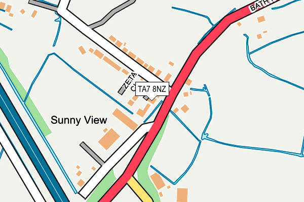
TA7 8NZ lies on Tracey Close in Bridgwater. TA7 8NZ is located in the Bridgwater East & Bawdrip electoral ward, within the unitary authority of Somerset and the English Parliamentary constituency of Bridgwater and West Somerset. The Sub Integrated Care Board (ICB) Location is NHS Somerset ICB - 11X and the police force is Avon and Somerset. This postcode has been in use since June 2000.


GetTheData
Source: OS OpenMap – Local (Ordnance Survey)
Source: OS VectorMap District (Ordnance Survey)
Licence: Open Government Licence (requires attribution)
| Easting | 332169 |
| Northing | 138886 |
| Latitude | 51.145196 |
| Longitude | -2.971070 |
GetTheData
Source: Open Postcode Geo
Licence: Open Government Licence
| Street | Tracey Close |
| Town/City | Bridgwater |
| Country | England |
| Postcode District | TA7 |
| ➜ TA7 open data dashboard ➜ See where TA7 is on a map ➜ Where is Horsey? | |
GetTheData
Source: Land Registry Price Paid Data
Licence: Open Government Licence
Elevation or altitude of TA7 8NZ as distance above sea level:
| Metres | Feet | |
|---|---|---|
| Elevation | 10m | 33ft |
Elevation is measured from the approximate centre of the postcode, to the nearest point on an OS contour line from OS Terrain 50, which has contour spacing of ten vertical metres.
➜ How high above sea level am I? Find the elevation of your current position using your device's GPS.
GetTheData
Source: Open Postcode Elevation
Licence: Open Government Licence
| Ward | Bridgwater East & Bawdrip |
| Constituency | Bridgwater And West Somerset |
GetTheData
Source: ONS Postcode Database
Licence: Open Government Licence
| December 2023 | Violence and sexual offences | On or near Tracey Close | 19m |
| December 2023 | Public order | On or near Tracey Close | 19m |
| July 2023 | Drugs | On or near Tracey Close | 19m |
| ➜ Tracey Close crime map and outcomes | |||
GetTheData
Source: data.police.uk
Licence: Open Government Licence
| Horsey Lane (Bath Road) | Horsey | 114m |
| Chedzoy Lane (Bath Road) | Horsey | 192m |
| Bradney Lane (Bath Road) | Horsey | 529m |
| Bradney Lane (Bath Road) | Horsey | 531m |
| Community Hospital | Bridgwater | 651m |
| Bridgwater Station | 2.4km |
GetTheData
Source: NaPTAN
Licence: Open Government Licence
| Percentage of properties with Next Generation Access | 100.0% |
| Percentage of properties with Superfast Broadband | 100.0% |
| Percentage of properties with Ultrafast Broadband | 0.0% |
| Percentage of properties with Full Fibre Broadband | 0.0% |
Superfast Broadband is between 30Mbps and 300Mbps
Ultrafast Broadband is > 300Mbps
| Percentage of properties unable to receive 2Mbps | 0.0% |
| Percentage of properties unable to receive 5Mbps | 0.0% |
| Percentage of properties unable to receive 10Mbps | 0.0% |
| Percentage of properties unable to receive 30Mbps | 0.0% |
GetTheData
Source: Ofcom
Licence: Ofcom Terms of Use (requires attribution)
GetTheData
Source: ONS Postcode Database
Licence: Open Government Licence


➜ Get more ratings from the Food Standards Agency
GetTheData
Source: Food Standards Agency
Licence: FSA terms & conditions
| Last Collection | |||
|---|---|---|---|
| Location | Mon-Fri | Sat | Distance |
| Horsey | 12:00 | 11:15 | 535m |
| Bradney | 11:00 | 11:00 | 1,406m |
| Bawdrip | 12:00 | 11:00 | 2,149m |
GetTheData
Source: Dracos
Licence: Creative Commons Attribution-ShareAlike
| Facility | Distance |
|---|---|
| Morganians Rfc Chedzoy Lane, Bridgwater Grass Pitches | 196m |
| Kingsdown Pavilion Kings Drive, Bridgwater Grass Pitches, Studio | 764m |
| Energie Fitness (Bridgwater) (Closed) Express Park, Bristol Road, Bridgwater Health and Fitness Gym, Studio | 1.4km |
GetTheData
Source: Active Places
Licence: Open Government Licence
| School | Phase of Education | Distance |
|---|---|---|
| Willowdown Primary School Kings Drive, Bridgwater, TA6 4FU | Primary | 609m |
| Bridgwater College Academy Parkway, Bridgwater, TA6 4QY | All-through | 1.6km |
| Bridgwater and Taunton College Bath Road, Bridgwater, TA6 4PZ | 16 plus | 1.9km |
GetTheData
Source: Edubase
Licence: Open Government Licence
| Risk of TA7 8NZ flooding from rivers and sea | Low |
| ➜ TA7 8NZ flood map | |
GetTheData
Source: Open Flood Risk by Postcode
Licence: Open Government Licence
The below table lists the International Territorial Level (ITL) codes (formerly Nomenclature of Territorial Units for Statistics (NUTS) codes) and Local Administrative Units (LAU) codes for TA7 8NZ:
| ITL 1 Code | Name |
|---|---|
| TLK | South West (England) |
| ITL 2 Code | Name |
| TLK2 | Dorset and Somerset |
| ITL 3 Code | Name |
| TLK23 | Somerset CC |
| LAU 1 Code | Name |
| E07000188 | Sedgemoor |
GetTheData
Source: ONS Postcode Directory
Licence: Open Government Licence
The below table lists the Census Output Area (OA), Lower Layer Super Output Area (LSOA), and Middle Layer Super Output Area (MSOA) for TA7 8NZ:
| Code | Name | |
|---|---|---|
| OA | E00148181 | |
| LSOA | E01029090 | Sedgemoor 010A |
| MSOA | E02006070 | Sedgemoor 010 |
GetTheData
Source: ONS Postcode Directory
Licence: Open Government Licence
| TA7 8QL | Zeta Close | 34m |
| TA7 8PF | Bath Road | 83m |
| TA7 8QJ | Horsey Lane | 129m |
| TA7 8QW | Chedzoy Lane | 432m |
| TA7 8PG | Bath Road | 448m |
| TA6 4TS | Bath Road | 623m |
| TA6 4UA | Whitfield Road | 693m |
| TA6 4ET | Petrel Close | 701m |
| TA6 4UD | Elmgrove Close | 703m |
| TA6 4EX | Severn Close | 723m |
GetTheData
Source: Open Postcode Geo; Land Registry Price Paid Data
Licence: Open Government Licence