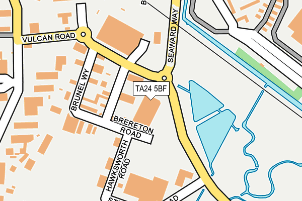
TA24 5BF is located in the Minehead electoral ward, within the unitary authority of Somerset and the English Parliamentary constituency of Bridgwater and West Somerset. The Sub Integrated Care Board (ICB) Location is NHS Somerset ICB - 11X and the police force is Avon and Somerset. This postcode has been in use since August 2016.


GetTheData
Source: OS OpenMap – Local (Ordnance Survey)
Source: OS VectorMap District (Ordnance Survey)
Licence: Open Government Licence (requires attribution)
| Easting | 297818 |
| Northing | 145878 |
| Latitude | 51.202943 |
| Longitude | -3.463992 |
GetTheData
Source: Open Postcode Geo
Licence: Open Government Licence
| Country | England |
| Postcode District | TA24 |
| ➜ TA24 open data dashboard ➜ See where TA24 is on a map ➜ Where is Minehead? | |
GetTheData
Source: Land Registry Price Paid Data
Licence: Open Government Licence
Elevation or altitude of TA24 5BF as distance above sea level:
| Metres | Feet | |
|---|---|---|
| Elevation | 10m | 33ft |
Elevation is measured from the approximate centre of the postcode, to the nearest point on an OS contour line from OS Terrain 50, which has contour spacing of ten vertical metres.
➜ How high above sea level am I? Find the elevation of your current position using your device's GPS.
GetTheData
Source: Open Postcode Elevation
Licence: Open Government Licence
| Ward | Minehead |
| Constituency | Bridgwater And West Somerset |
GetTheData
Source: ONS Postcode Database
Licence: Open Government Licence
| June 2022 | Vehicle crime | On or near Brunel Way | 145m |
| June 2022 | Shoplifting | On or near Brunel Way | 145m |
| June 2022 | Anti-social behaviour | On or near Brunel Way | 145m |
| ➜ Get more crime data in our Crime section | |||
GetTheData
Source: data.police.uk
Licence: Open Government Licence
| Brunel Way | Minehead | 145m |
| Brunel Way | Minehead | 152m |
| Tesco Supermarket (Stephenson Road) | Minehead | 192m |
| Butlins | Minehead | 403m |
| Hospital (Luttrell Way) | Minehead | 416m |
| Minehead (West Somerset Railway) | Minehead | 563m |
GetTheData
Source: NaPTAN
Licence: Open Government Licence
GetTheData
Source: ONS Postcode Database
Licence: Open Government Licence


➜ Get more ratings from the Food Standards Agency
GetTheData
Source: Food Standards Agency
Licence: FSA terms & conditions
| Last Collection | |||
|---|---|---|---|
| Location | Mon-Fri | Sat | Distance |
| Somerwest World | 16:30 | 12:00 | 392m |
| Staunton Road | 16:30 | 12:15 | 699m |
| The Avenue Post Office | 17:00 | 12:30 | 854m |
GetTheData
Source: Dracos
Licence: Creative Commons Attribution-ShareAlike
| Facility | Distance |
|---|---|
| Aquasplash (Minehead) (Closed) Seaward Way, Minehead Swimming Pool, Health and Fitness Gym | 6m |
| King George V Playing Field (Minehead) King George Road, Minehead Grass Pitches | 346m |
| West Somerset College Bircham Road, Minehead Sports Hall, Health and Fitness Gym, Artificial Grass Pitch, Grass Pitches, Studio, Squash Courts, Athletics | 632m |
GetTheData
Source: Active Places
Licence: Open Government Licence
| School | Phase of Education | Distance |
|---|---|---|
| Minehead Middle School Ponsford Road, Minehead, TA24 5RH | Middle deemed secondary | 606m |
| West Somerset College Bircham Road, Alcombe, Minehead, TA24 6AY | Secondary | 732m |
| Minehead First School Townsend Road, Minehead, TA24 5RG | Primary | 950m |
GetTheData
Source: Edubase
Licence: Open Government Licence
| Risk of TA24 5BF flooding from rivers and sea | Very Low |
| ➜ TA24 5BF flood map | |
GetTheData
Source: Open Flood Risk by Postcode
Licence: Open Government Licence
The below table lists the International Territorial Level (ITL) codes (formerly Nomenclature of Territorial Units for Statistics (NUTS) codes) and Local Administrative Units (LAU) codes for TA24 5BF:
| ITL 1 Code | Name |
|---|---|
| TLK | South West (England) |
| ITL 2 Code | Name |
| TLK2 | Dorset and Somerset |
| ITL 3 Code | Name |
| TLK23 | Somerset CC |
| LAU 1 Code | Name |
| E07000246 | Somerset West and Taunton |
GetTheData
Source: ONS Postcode Directory
Licence: Open Government Licence
The below table lists the Census Output Area (OA), Lower Layer Super Output Area (LSOA), and Middle Layer Super Output Area (MSOA) for TA24 5BF:
| Code | Name | |
|---|---|---|
| OA | E00149450 | |
| LSOA | E01029329 | West Somerset 001C |
| MSOA | E02006113 | West Somerset 001 |
GetTheData
Source: ONS Postcode Directory
Licence: Open Government Licence
| TA24 5BY | Brunel Way | 98m |
| TA24 6GN | Trinity Way | 216m |
| TA24 6GR | Bowsprit Close | 246m |
| TA24 6GA | Rope Walk | 291m |
| TA24 6GE | Trinity Way | 305m |
| TA24 6DE | Hayfield Close | 307m |
| TA24 6GF | Trinity Way | 314m |
| TA24 5BJ | Mart Road | 320m |
| TA24 6GB | Lightermans Close | 343m |
| TA24 6GG | Trinity Way | 346m |
GetTheData
Source: Open Postcode Geo; Land Registry Price Paid Data
Licence: Open Government Licence