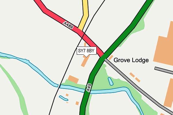
SY7 8BY is located in the Church Stretton and Craven Arms electoral ward, within the unitary authority of Shropshire and the English Parliamentary constituency of Ludlow. The Sub Integrated Care Board (ICB) Location is NHS Shropshire, Telford and Wrekin ICB - M2L0M and the police force is West Mercia. This postcode has been in use since April 1987.


GetTheData
Source: OS OpenMap – Local (Ordnance Survey)
Source: OS VectorMap District (Ordnance Survey)
Licence: Open Government Licence (requires attribution)
| Easting | 343231 |
| Northing | 284778 |
| Latitude | 52.457986 |
| Longitude | -2.836891 |
GetTheData
Source: Open Postcode Geo
Licence: Open Government Licence
| Country | England |
| Postcode District | SY7 |
| ➜ SY7 open data dashboard ➜ See where SY7 is on a map ➜ Where is The Grove? | |
GetTheData
Source: Land Registry Price Paid Data
Licence: Open Government Licence
Elevation or altitude of SY7 8BY as distance above sea level:
| Metres | Feet | |
|---|---|---|
| Elevation | 130m | 427ft |
Elevation is measured from the approximate centre of the postcode, to the nearest point on an OS contour line from OS Terrain 50, which has contour spacing of ten vertical metres.
➜ How high above sea level am I? Find the elevation of your current position using your device's GPS.
GetTheData
Source: Open Postcode Elevation
Licence: Open Government Licence
| Ward | Church Stretton And Craven Arms |
| Constituency | Ludlow |
GetTheData
Source: ONS Postcode Database
Licence: Open Government Licence
| October 2021 | Other theft | On or near Grove Drive | 280m |
| ➜ Get more crime data in our Crime section | |||
GetTheData
Source: data.police.uk
Licence: Open Government Licence
| Jewson (A489) | Grove Bank | 40m |
| Jewson (A489) | Grove Bank | 49m |
| The Grove Jct (A49) | Grove Bank | 72m |
| The Grove Jct (A49) | Grove Bank | 74m |
| Wistanstow Jct (A49) | Grove Bank | 649m |
| Craven Arms Station | 1.7km |
| Broome Station | 5.1km |
GetTheData
Source: NaPTAN
Licence: Open Government Licence
GetTheData
Source: ONS Postcode Database
Licence: Open Government Licence


➜ Get more ratings from the Food Standards Agency
GetTheData
Source: Food Standards Agency
Licence: FSA terms & conditions
| Last Collection | |||
|---|---|---|---|
| Location | Mon-Fri | Sat | Distance |
| Wistanstow | 16:30 | 09:00 | 555m |
| Stokesay Bridge | 11:00 | 11:00 | 2,953m |
GetTheData
Source: Dracos
Licence: Creative Commons Attribution-ShareAlike
| Facility | Distance |
|---|---|
| Community Arts Sports Craven Arms (Casca) Newington Way, Craven Arms Sports Hall, Outdoor Tennis Courts, Grass Pitches | 1.7km |
| Craven Arms Sports Field Shrewsbury Road, Craven Arms Grass Pitches, Cycling | 1.7km |
GetTheData
Source: Active Places
Licence: Open Government Licence
| School | Phase of Education | Distance |
|---|---|---|
| Wistanstow CofE Primary School Wistanstow, Craven Arms, SY7 8DQ | Primary | 863m |
| Stokesay Primary School Market Street, Craven Arms, SY7 9NW | Primary | 2.2km |
GetTheData
Source: Edubase
Licence: Open Government Licence
| Risk of SY7 8BY flooding from rivers and sea | Medium |
| ➜ SY7 8BY flood map | |
GetTheData
Source: Open Flood Risk by Postcode
Licence: Open Government Licence
The below table lists the International Territorial Level (ITL) codes (formerly Nomenclature of Territorial Units for Statistics (NUTS) codes) and Local Administrative Units (LAU) codes for SY7 8BY:
| ITL 1 Code | Name |
|---|---|
| TLG | West Midlands (England) |
| ITL 2 Code | Name |
| TLG2 | Shropshire and Staffordshire |
| ITL 3 Code | Name |
| TLG22 | Shropshire |
| LAU 1 Code | Name |
| E06000051 | Shropshire |
GetTheData
Source: ONS Postcode Directory
Licence: Open Government Licence
The below table lists the Census Output Area (OA), Lower Layer Super Output Area (LSOA), and Middle Layer Super Output Area (MSOA) for SY7 8BY:
| Code | Name | |
|---|---|---|
| OA | E00147772 | |
| LSOA | E01029016 | Shropshire 037D |
| MSOA | E02006044 | Shropshire 037 |
GetTheData
Source: ONS Postcode Directory
Licence: Open Government Licence
| SY7 8DA | Grove Drive | 199m |
| SY7 8DP | 446m | |
| SY7 8BX | Shrewsbury Road | 531m |
| SY7 8DD | Grove Bank | 621m |
| SY7 8DG | 647m | |
| SY7 8DQ | 916m | |
| SY7 8DB | Greene Close | 967m |
| SY7 8DR | 1152m | |
| SY7 8BT | 1171m | |
| SY7 8DU | Long Lane | 1183m |
GetTheData
Source: Open Postcode Geo; Land Registry Price Paid Data
Licence: Open Government Licence