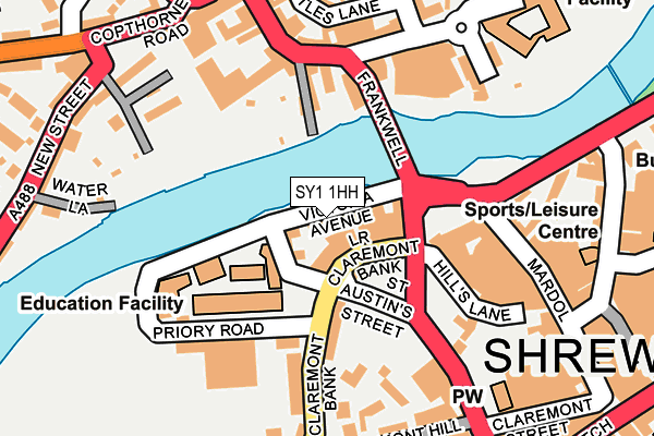
SY1 1HH is located in the Quarry and Coton Hill electoral ward, within the unitary authority of Shropshire and the English Parliamentary constituency of Shrewsbury and Atcham. The Sub Integrated Care Board (ICB) Location is NHS Shropshire, Telford and Wrekin ICB - M2L0M and the police force is West Mercia. This postcode has been in use since June 1996.


GetTheData
Source: OS OpenMap – Local (Ordnance Survey)
Source: OS VectorMap District (Ordnance Survey)
Licence: Open Government Licence (requires attribution)
| Easting | 348821 |
| Northing | 312698 |
| Latitude | 52.709513 |
| Longitude | -2.758956 |
GetTheData
Source: Open Postcode Geo
Licence: Open Government Licence
| Country | England |
| Postcode District | SY1 |
| ➜ SY1 open data dashboard ➜ See where SY1 is on a map ➜ Where is Shrewsbury? | |
GetTheData
Source: Land Registry Price Paid Data
Licence: Open Government Licence
Elevation or altitude of SY1 1HH as distance above sea level:
| Metres | Feet | |
|---|---|---|
| Elevation | 50m | 164ft |
Elevation is measured from the approximate centre of the postcode, to the nearest point on an OS contour line from OS Terrain 50, which has contour spacing of ten vertical metres.
➜ How high above sea level am I? Find the elevation of your current position using your device's GPS.
GetTheData
Source: Open Postcode Elevation
Licence: Open Government Licence
| Ward | Quarry And Coton Hill |
| Constituency | Shrewsbury And Atcham |
GetTheData
Source: ONS Postcode Database
Licence: Open Government Licence
| January 2024 | Anti-social behaviour | On or near Parking Area | 140m |
| January 2024 | Drugs | On or near Parking Area | 140m |
| January 2024 | Theft from the person | On or near Parking Area | 140m |
| ➜ Get more crime data in our Crime section | |||
GetTheData
Source: data.police.uk
Licence: Open Government Licence
| Victoria Quay (Victoria Avenue) | Shrewsbury | 38m |
| Car Park (Bridge Street) | Shrewsbury | 111m |
| Barker Street P&r (Barker Street) | Shrewsbury | 159m |
| Rowleys House (Barker Street) | Shrewsbury | 166m |
| Mardol Jct (Smithfield Road) | Shrewsbury | 177m |
| Shrewsbury Station | 0.7km |
GetTheData
Source: NaPTAN
Licence: Open Government Licence
GetTheData
Source: ONS Postcode Database
Licence: Open Government Licence


➜ Get more ratings from the Food Standards Agency
GetTheData
Source: Food Standards Agency
Licence: FSA terms & conditions
| Last Collection | |||
|---|---|---|---|
| Location | Mon-Fri | Sat | Distance |
| Hills Lane | 19:30 | 12:00 | 177m |
| Quarry Gates | 19:30 | 12:30 | 215m |
| Frankwell Post Office | 19:30 | 12:00 | 242m |
GetTheData
Source: Dracos
Licence: Creative Commons Attribution-ShareAlike
| Facility | Distance |
|---|---|
| Anytime Fitness (Shrewsbury) Lower Claremont Bank, Shrewsbury Health and Fitness Gym, Studio | 39m |
| Silks Meadow Recreation Ground Silkmoor, New Street, Shrewsbury Outdoor Tennis Courts | 128m |
| Quarry Swimming & Fitness Centre Priory Road, Shrewsbury Swimming Pool, Health and Fitness Gym, Studio | 143m |
GetTheData
Source: Active Places
Licence: Open Government Licence
| School | Phase of Education | Distance |
|---|---|---|
| Shrewsbury Colleges Group Priory Road, Shrewsbury, SY1 1RX | 16 plus | 107m |
| Shrewsbury High School 32 Town Walls, Shrewsbury, Shropshire, SY1 1TN | Not applicable | 455m |
| St Winefride's Convent School Belmont, Shrewsbury, SY1 1TE | Not applicable | 512m |
GetTheData
Source: Edubase
Licence: Open Government Licence
| Risk of SY1 1HH flooding from rivers and sea | Medium |
| ➜ SY1 1HH flood map | |
GetTheData
Source: Open Flood Risk by Postcode
Licence: Open Government Licence
The below table lists the International Territorial Level (ITL) codes (formerly Nomenclature of Territorial Units for Statistics (NUTS) codes) and Local Administrative Units (LAU) codes for SY1 1HH:
| ITL 1 Code | Name |
|---|---|
| TLG | West Midlands (England) |
| ITL 2 Code | Name |
| TLG2 | Shropshire and Staffordshire |
| ITL 3 Code | Name |
| TLG22 | Shropshire |
| LAU 1 Code | Name |
| E06000051 | Shropshire |
GetTheData
Source: ONS Postcode Directory
Licence: Open Government Licence
The below table lists the Census Output Area (OA), Lower Layer Super Output Area (LSOA), and Middle Layer Super Output Area (MSOA) for SY1 1HH:
| Code | Name | |
|---|---|---|
| OA | E00147397 | |
| LSOA | E01028946 | Shropshire 019A |
| MSOA | E02006033 | Shropshire 019 |
GetTheData
Source: ONS Postcode Directory
Licence: Open Government Licence
| SY1 1RW | Claremont Bank | 118m |
| SY1 1RJ | Claremont Bank | 144m |
| SY3 8LG | Frankwell | 150m |
| SY1 1RU | Priory Road | 163m |
| SY1 1RG | Claremont Place | 166m |
| SY3 8JU | Frankwell | 168m |
| SY1 1QU | Hills Lane | 173m |
| SY3 8JX | Frankwell | 180m |
| SY3 8JL | New Street | 184m |
| SY1 1PU | Mardol | 185m |
GetTheData
Source: Open Postcode Geo; Land Registry Price Paid Data
Licence: Open Government Licence