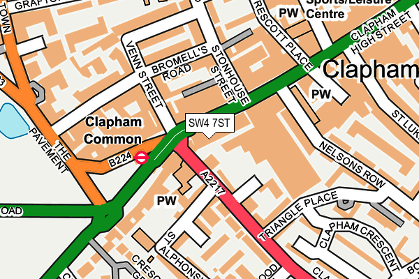
SW4 7ST is located in the Clapham East electoral ward, within the London borough of Lambeth and the English Parliamentary constituency of Vauxhall. The Sub Integrated Care Board (ICB) Location is NHS South East London ICB - 72Q and the police force is Metropolitan Police. This postcode has been in use since January 1980.


GetTheData
Source: OS OpenMap – Local (Ordnance Survey)
Source: OS VectorMap District (Ordnance Survey)
Licence: Open Government Licence (requires attribution)
| Easting | 529525 |
| Northing | 175317 |
| Latitude | 51.462015 |
| Longitude | -0.136910 |
GetTheData
Source: Open Postcode Geo
Licence: Open Government Licence
| Country | England |
| Postcode District | SW4 |
| ➜ SW4 open data dashboard ➜ See where SW4 is on a map ➜ Where is Clapham? | |
GetTheData
Source: Land Registry Price Paid Data
Licence: Open Government Licence
Elevation or altitude of SW4 7ST as distance above sea level:
| Metres | Feet | |
|---|---|---|
| Elevation | 20m | 66ft |
Elevation is measured from the approximate centre of the postcode, to the nearest point on an OS contour line from OS Terrain 50, which has contour spacing of ten vertical metres.
➜ How high above sea level am I? Find the elevation of your current position using your device's GPS.
GetTheData
Source: Open Postcode Elevation
Licence: Open Government Licence
| Ward | Clapham East |
| Constituency | Vauxhall |
GetTheData
Source: ONS Postcode Database
Licence: Open Government Licence
| January 2024 | Robbery | On or near Tableer Avenue | 401m |
| December 2023 | Violence and sexual offences | On or near Tableer Avenue | 401m |
| November 2023 | Violence and sexual offences | On or near Tableer Avenue | 401m |
| ➜ Get more crime data in our Crime section | |||
GetTheData
Source: data.police.uk
Licence: Open Government Licence
| Clapham Common (Clapham Common South Side) | Clapham Common | 106m |
| Nelson's Row | Clapham Common | 111m |
| Clapham Common (The Pavement) | Clapham Common | 123m |
| Clapham Common (Clapham Common South Side) | Clapham Common | 124m |
| Clapham Common (Clapham Common South Side) | Clapham Common | 145m |
| Clapham Common Underground Station | Clapham | 102m |
| Clapham North Underground Station | Clapham | 591m |
| Clapham South Underground Station | Clapham South | 1,279m |
| Stockwell Underground Station | Stockwell | 1,504m |
| Clapham High Street Station | 0.5km |
| Wandsworth Road Station | 0.9km |
| Brixton Station | 1.6km |
GetTheData
Source: NaPTAN
Licence: Open Government Licence
GetTheData
Source: ONS Postcode Database
Licence: Open Government Licence


➜ Get more ratings from the Food Standards Agency
GetTheData
Source: Food Standards Agency
Licence: FSA terms & conditions
| Last Collection | |||
|---|---|---|---|
| Location | Mon-Fri | Sat | Distance |
| Post Office | 17:30 | 12:00 | 10m |
| 15 / 16 Southside | 17:30 | 12:00 | 123m |
| 66 Venn Street S W 4 0 A U | 17:30 | 12:00 | 174m |
GetTheData
Source: Dracos
Licence: Creative Commons Attribution-ShareAlike
| Facility | Distance |
|---|---|
| Puregym (London Clapham) Clapham High Street, London Health and Fitness Gym, Studio | 218m |
| Clapham Leisure Centre Clapham Manor Street, London Health and Fitness Gym, Swimming Pool, Sports Hall, Studio | 277m |
| Clapham Leisure Centre (Closed) Clapham Manor Street, London Sports Hall, Swimming Pool, Health and Fitness Gym, Studio | 321m |
GetTheData
Source: Active Places
Licence: Open Government Licence
| School | Phase of Education | Distance |
|---|---|---|
| Clapham Manor Primary School Belmont Road, Clapham, London, SW4 0BZ | Primary | 270m |
| Triangle Nursery School 25 William Bonney Estate, Clapham Crescent, London, SW4 7JQ | Nursery | 292m |
| St Mary's Roman Catholic Primary School Crescent Lane, Clapham, London, SW4 9QJ | Primary | 332m |
GetTheData
Source: Edubase
Licence: Open Government Licence
The below table lists the International Territorial Level (ITL) codes (formerly Nomenclature of Territorial Units for Statistics (NUTS) codes) and Local Administrative Units (LAU) codes for SW4 7ST:
| ITL 1 Code | Name |
|---|---|
| TLI | London |
| ITL 2 Code | Name |
| TLI4 | Inner London - East |
| ITL 3 Code | Name |
| TLI45 | Lambeth |
| LAU 1 Code | Name |
| E09000022 | Lambeth |
GetTheData
Source: ONS Postcode Directory
Licence: Open Government Licence
The below table lists the Census Output Area (OA), Lower Layer Super Output Area (LSOA), and Middle Layer Super Output Area (MSOA) for SW4 7ST:
| Code | Name | |
|---|---|---|
| OA | E00015327 | |
| LSOA | E01003041 | Lambeth 017C |
| MSOA | E02000634 | Lambeth 017 |
GetTheData
Source: ONS Postcode Directory
Licence: Open Government Licence
| SW4 7SS | Clapham High Street | 31m |
| SW4 7UG | Clapham High Street | 54m |
| SW4 7AA | Clapham Common South Side | 82m |
| SW4 0AD | Hanscomb Mews | 82m |
| SW4 0BD | Venn Street | 98m |
| SW4 6BE | Stonhouse Street | 103m |
| SW4 7EE | Clapham Park Road | 107m |
| SW4 7AQ | Clapham Park Road | 111m |
| SW4 7AD | Clapham Common South Side | 112m |
| SW4 7JT | Nelsons Row | 132m |
GetTheData
Source: Open Postcode Geo; Land Registry Price Paid Data
Licence: Open Government Licence