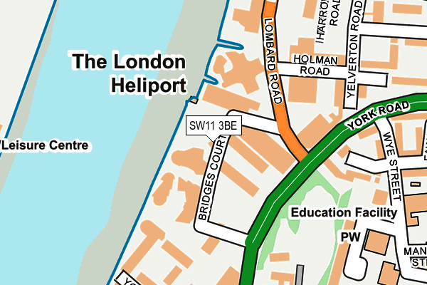
SW11 3BE is located in the St Mary's electoral ward, within the London borough of Wandsworth and the English Parliamentary constituency of Battersea. The Sub Integrated Care Board (ICB) Location is NHS South West London ICB - 36L and the police force is Metropolitan Police. This postcode has been in use since April 2010.


GetTheData
Source: OS OpenMap – Local (Ordnance Survey)
Source: OS VectorMap District (Ordnance Survey)
Licence: Open Government Licence (requires attribution)
| Easting | 526606 |
| Northing | 176073 |
| Latitude | 51.469469 |
| Longitude | -0.178635 |
GetTheData
Source: Open Postcode Geo
Licence: Open Government Licence
| Country | England |
| Postcode District | SW11 |
| ➜ SW11 open data dashboard ➜ See where SW11 is on a map ➜ Where is London? | |
GetTheData
Source: Land Registry Price Paid Data
Licence: Open Government Licence
Elevation or altitude of SW11 3BE as distance above sea level:
| Metres | Feet | |
|---|---|---|
| Elevation | 10m | 33ft |
Elevation is measured from the approximate centre of the postcode, to the nearest point on an OS contour line from OS Terrain 50, which has contour spacing of ten vertical metres.
➜ How high above sea level am I? Find the elevation of your current position using your device's GPS.
GetTheData
Source: Open Postcode Elevation
Licence: Open Government Licence
| Ward | St Mary's |
| Constituency | Battersea |
GetTheData
Source: ONS Postcode Database
Licence: Open Government Licence
| January 2024 | Burglary | On or near Fowler Close | 479m |
| December 2023 | Anti-social behaviour | On or near Fowler Close | 479m |
| December 2023 | Violence and sexual offences | On or near Fowler Close | 479m |
| ➜ Get more crime data in our Crime section | |||
GetTheData
Source: data.police.uk
Licence: Open Government Licence
| York Gardens (York Road) | Clapham Junction | 113m |
| Lombard Road | Clapham Junction | 118m |
| Lombard Road | Clapham Junction | 151m |
| York Gardens | Clapham Junction | 248m |
| Badric Court | Clapham Junction | 275m |
| Fulham Broadway Underground Station | Fulham Broadway | 1,659m |
| Imperial Wharf Station | 0.7km |
| Clapham Junction Station | 0.8km |
| Wandsworth Town Station | 1.1km |
GetTheData
Source: NaPTAN
Licence: Open Government Licence
GetTheData
Source: ONS Postcode Database
Licence: Open Government Licence

➜ Get more ratings from the Food Standards Agency
GetTheData
Source: Food Standards Agency
Licence: FSA terms & conditions
| Last Collection | |||
|---|---|---|---|
| Location | Mon-Fri | Sat | Distance |
| 70 York Road | 17:30 | 12:00 | 200m |
| 12 Lavender Road | 17:30 | 12:00 | 288m |
| 200 York Road | 17:30 | 12:00 | 446m |
GetTheData
Source: Dracos
Licence: Creative Commons Attribution-ShareAlike
| Facility | Distance |
|---|---|
| Yorky's Gym (Closed) York Road, London Health and Fitness Gym | 382m |
| Harbour Club (Chelsea) Watermeadow Lane, London Swimming Pool, Health and Fitness Gym, Indoor Tennis Centre, Studio, Sports Hall | 419m |
| Energie Fitness (Battersea) Falcon Road, Falcon Road, London Health and Fitness Gym | 512m |
GetTheData
Source: Active Places
Licence: Open Government Licence
| School | Phase of Education | Distance |
|---|---|---|
| Falconbrook Primary School Wye Street, Battersea, London, SW11 2LX | Primary | 293m |
| Thames Christian School 12 Grant Road, London, SW11 2FR | Not applicable | 611m |
| Thomas's Battersea 28-40 Battersea High Street, London, SW11 3JB | Not applicable | 619m |
GetTheData
Source: Edubase
Licence: Open Government Licence
| Risk of SW11 3BE flooding from rivers and sea | Very Low |
| ➜ SW11 3BE flood map | |
GetTheData
Source: Open Flood Risk by Postcode
Licence: Open Government Licence
The below table lists the International Territorial Level (ITL) codes (formerly Nomenclature of Territorial Units for Statistics (NUTS) codes) and Local Administrative Units (LAU) codes for SW11 3BE:
| ITL 1 Code | Name |
|---|---|
| TLI | London |
| ITL 2 Code | Name |
| TLI3 | Inner London - West |
| ITL 3 Code | Name |
| TLI34 | Wandsworth |
| LAU 1 Code | Name |
| E09000032 | Wandsworth |
GetTheData
Source: ONS Postcode Directory
Licence: Open Government Licence
The below table lists the Census Output Area (OA), Lower Layer Super Output Area (LSOA), and Middle Layer Super Output Area (MSOA) for SW11 3BE:
| Code | Name | |
|---|---|---|
| OA | E00171069 | |
| LSOA | E01033133 | Wandsworth 004G |
| MSOA | E02000926 | Wandsworth 004 |
GetTheData
Source: ONS Postcode Directory
Licence: Open Government Licence
| SW11 3GZ | Bridges Court Road | 38m |
| SW11 3SS | Heliport Industrial Estate | 58m |
| SW11 3GW | Bridges Court Road | 87m |
| SW11 3GX | Bridges Court Road | 87m |
| SW11 3GY | Bridges Court Road | 96m |
| SW11 3RF | Lombard Road | 108m |
| SW11 3RY | Lombard Road | 108m |
| SW11 3YS | Cotton Row | 158m |
| SW11 3PG | Holman Road | 175m |
| SW11 3RU | Lombard Road | 181m |
GetTheData
Source: Open Postcode Geo; Land Registry Price Paid Data
Licence: Open Government Licence