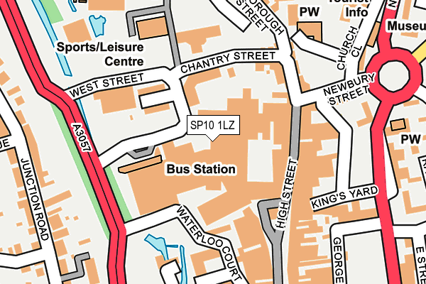
SP10 1LZ is located in the Andover St Mary's electoral ward, within the local authority district of Test Valley and the English Parliamentary constituency of North West Hampshire. The Sub Integrated Care Board (ICB) Location is NHS Hampshire and Isle of Wight ICB - D9Y0V and the police force is Hampshire. This postcode has been in use since January 1980.


GetTheData
Source: OS OpenMap – Local (Ordnance Survey)
Source: OS VectorMap District (Ordnance Survey)
Licence: Open Government Licence (requires attribution)
| Easting | 436385 |
| Northing | 145627 |
| Latitude | 51.208693 |
| Longitude | -1.480513 |
GetTheData
Source: Open Postcode Geo
Licence: Open Government Licence
| Country | England |
| Postcode District | SP10 |
| ➜ SP10 open data dashboard ➜ See where SP10 is on a map ➜ Where is Andover? | |
GetTheData
Source: Land Registry Price Paid Data
Licence: Open Government Licence
Elevation or altitude of SP10 1LZ as distance above sea level:
| Metres | Feet | |
|---|---|---|
| Elevation | 60m | 197ft |
Elevation is measured from the approximate centre of the postcode, to the nearest point on an OS contour line from OS Terrain 50, which has contour spacing of ten vertical metres.
➜ How high above sea level am I? Find the elevation of your current position using your device's GPS.
GetTheData
Source: Open Postcode Elevation
Licence: Open Government Licence
| Ward | Andover St Mary's |
| Constituency | North West Hampshire |
GetTheData
Source: ONS Postcode Database
Licence: Open Government Licence
| January 2024 | Anti-social behaviour | On or near Parking Area | 206m |
| January 2024 | Public order | On or near Parking Area | 280m |
| January 2024 | Violence and sexual offences | On or near Parking Area | 280m |
| ➜ Get more crime data in our Crime section | |||
GetTheData
Source: data.police.uk
Licence: Open Government Licence
| Leisure Centre (West Street) | Andover | 150m |
| Kings Yard (East Street) | Andover | 242m |
| Methodist Church (Bridge Street) | Andover | 252m |
| Eastfield Road (Eastern Street) | Andover | 310m |
| Church Close (New Street) | Andover | 342m |
| Andover Station | 0.9km |
GetTheData
Source: NaPTAN
Licence: Open Government Licence
GetTheData
Source: ONS Postcode Database
Licence: Open Government Licence


➜ Get more ratings from the Food Standards Agency
GetTheData
Source: Food Standards Agency
Licence: FSA terms & conditions
| Last Collection | |||
|---|---|---|---|
| Location | Mon-Fri | Sat | Distance |
| High Street (Tesco) | 18:30 | 12:30 | 94m |
| The High Street | 17:45 | 12:30 | 172m |
| High Street (Lloyds Bank) | 18:30 | 12:30 | 254m |
GetTheData
Source: Dracos
Licence: Creative Commons Attribution-ShareAlike
| Facility | Distance |
|---|---|
| Andover Leisure Centre West Street, Andover Sports Hall, Swimming Pool, Health and Fitness Gym, Studio, Squash Courts | 165m |
| Vigo Road Recreation Ground Beales Close, Andover Outdoor Tennis Courts | 436m |
| Charlton Place Fitness Centre Charlton Road, Andover Health and Fitness Gym, Artificial Grass Pitch | 465m |
GetTheData
Source: Active Places
Licence: Open Government Licence
| School | Phase of Education | Distance |
|---|---|---|
| Andover Church of England Primary School East Street, Andover, SP10 1EP | Primary | 399m |
| Wolverdene Special School 22 Love Lane, Andover, SP10 2AF | Not applicable | 651m |
| Rookwood School Weyhill Road, Andover, SP10 3AL | Not applicable | 910m |
GetTheData
Source: Edubase
Licence: Open Government Licence
The below table lists the International Territorial Level (ITL) codes (formerly Nomenclature of Territorial Units for Statistics (NUTS) codes) and Local Administrative Units (LAU) codes for SP10 1LZ:
| ITL 1 Code | Name |
|---|---|
| TLJ | South East (England) |
| ITL 2 Code | Name |
| TLJ3 | Hampshire and Isle of Wight |
| ITL 3 Code | Name |
| TLJ36 | Central Hampshire |
| LAU 1 Code | Name |
| E07000093 | Test Valley |
GetTheData
Source: ONS Postcode Directory
Licence: Open Government Licence
The below table lists the Census Output Area (OA), Lower Layer Super Output Area (LSOA), and Middle Layer Super Output Area (MSOA) for SP10 1LZ:
| Code | Name | |
|---|---|---|
| OA | E00117896 | |
| LSOA | E01023202 | Test Valley 003C |
| MSOA | E02004816 | Test Valley 003 |
GetTheData
Source: ONS Postcode Directory
Licence: Open Government Licence
| SP10 1DB | Portland Grove | 95m |
| SP10 1LP | High Street | 104m |
| SP10 1QP | West Street | 107m |
| SP10 1QJ | Waterloo Court | 123m |
| SP10 1ND | High Street | 125m |
| SP10 1NG | High Street | 131m |
| SP10 1NF | High Street | 138m |
| SP10 1DE | Chantry Street | 140m |
| SP10 1NE | High Street | 151m |
| SP10 1NN | High Street | 169m |
GetTheData
Source: Open Postcode Geo; Land Registry Price Paid Data
Licence: Open Government Licence