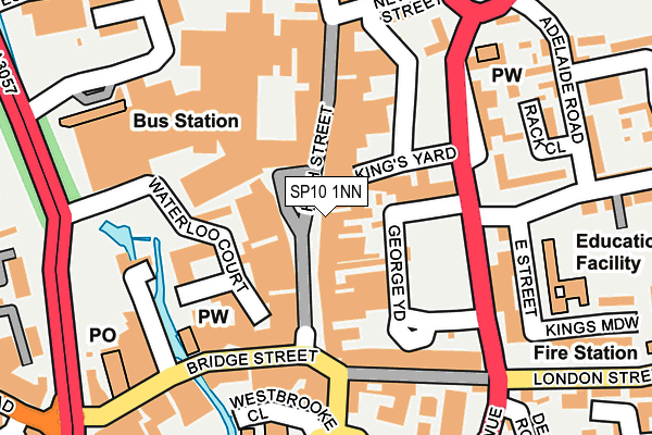
SP10 1NN lies on High Street in Andover. SP10 1NN is located in the Andover St Mary's electoral ward, within the local authority district of Test Valley and the English Parliamentary constituency of North West Hampshire. The Sub Integrated Care Board (ICB) Location is NHS Hampshire and Isle of Wight ICB - D9Y0V and the police force is Hampshire. This postcode has been in use since January 1980.


GetTheData
Source: OS OpenMap – Local (Ordnance Survey)
Source: OS VectorMap District (Ordnance Survey)
Licence: Open Government Licence (requires attribution)
| Easting | 436497 |
| Northing | 145500 |
| Latitude | 51.207548 |
| Longitude | -1.478935 |
GetTheData
Source: Open Postcode Geo
Licence: Open Government Licence
| Street | High Street |
| Town/City | Andover |
| Country | England |
| Postcode District | SP10 |
➜ See where SP10 is on a map ➜ Where is Andover? | |
GetTheData
Source: Land Registry Price Paid Data
Licence: Open Government Licence
Elevation or altitude of SP10 1NN as distance above sea level:
| Metres | Feet | |
|---|---|---|
| Elevation | 60m | 197ft |
Elevation is measured from the approximate centre of the postcode, to the nearest point on an OS contour line from OS Terrain 50, which has contour spacing of ten vertical metres.
➜ How high above sea level am I? Find the elevation of your current position using your device's GPS.
GetTheData
Source: Open Postcode Elevation
Licence: Open Government Licence
| Ward | Andover St Mary's |
| Constituency | North West Hampshire |
GetTheData
Source: ONS Postcode Database
Licence: Open Government Licence
| Kings Yard (East Street) | Andover | 129m |
| Eastfield Road (Eastern Street) | Andover | 153m |
| Methodist Church (Bridge Street) | Andover | 156m |
| East Street School (East Street) | Andover | 203m |
| Vincent House (London Street) | Andover | 260m |
| Andover Station | 1km |
GetTheData
Source: NaPTAN
Licence: Open Government Licence
GetTheData
Source: ONS Postcode Database
Licence: Open Government Licence


➜ Get more ratings from the Food Standards Agency
GetTheData
Source: Food Standards Agency
Licence: FSA terms & conditions
| Last Collection | |||
|---|---|---|---|
| Location | Mon-Fri | Sat | Distance |
| High Street (Tesco) | 18:30 | 12:30 | 78m |
| High Street (Lloyds Bank) | 18:30 | 12:30 | 87m |
| The High Street | 17:45 | 12:30 | 233m |
GetTheData
Source: Dracos
Licence: Creative Commons Attribution-ShareAlike
The below table lists the International Territorial Level (ITL) codes (formerly Nomenclature of Territorial Units for Statistics (NUTS) codes) and Local Administrative Units (LAU) codes for SP10 1NN:
| ITL 1 Code | Name |
|---|---|
| TLJ | South East (England) |
| ITL 2 Code | Name |
| TLJ3 | Hampshire and Isle of Wight |
| ITL 3 Code | Name |
| TLJ36 | Central Hampshire |
| LAU 1 Code | Name |
| E07000093 | Test Valley |
GetTheData
Source: ONS Postcode Directory
Licence: Open Government Licence
The below table lists the Census Output Area (OA), Lower Layer Super Output Area (LSOA), and Middle Layer Super Output Area (MSOA) for SP10 1NN:
| Code | Name | |
|---|---|---|
| OA | E00117896 | |
| LSOA | E01023202 | Test Valley 003C |
| MSOA | E02004816 | Test Valley 003 |
GetTheData
Source: ONS Postcode Directory
Licence: Open Government Licence
| SP10 1NF | High Street | 50m |
| SP10 1PA | Union Street | 77m |
| SP10 1LP | High Street | 81m |
| SP10 1QJ | Waterloo Court | 100m |
| SP10 1BH | Bridge Street | 134m |
| SP10 2NU | London Street | 152m |
| SP10 1NG | High Street | 157m |
| SP10 2PA | London Street | 165m |
| SP10 1HB | Rack Close | 167m |
| SP10 1ES | East Street | 174m |
GetTheData
Source: Open Postcode Geo; Land Registry Price Paid Data
Licence: Open Government Licence