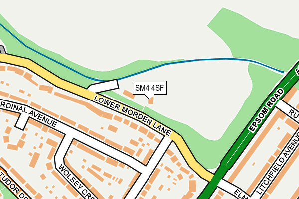
SM4 4SF is located in the Lower Morden electoral ward, within the London borough of Merton and the English Parliamentary constituency of Mitcham and Morden. The Sub Integrated Care Board (ICB) Location is NHS South West London ICB - 36L and the police force is Metropolitan Police. This postcode has been in use since September 1991.


GetTheData
Source: OS OpenMap – Local (Ordnance Survey)
Source: OS VectorMap District (Ordnance Survey)
Licence: Open Government Licence (requires attribution)
| Easting | 524551 |
| Northing | 167117 |
| Latitude | 51.389434 |
| Longitude | -0.211326 |
GetTheData
Source: Open Postcode Geo
Licence: Open Government Licence
| Country | England |
| Postcode District | SM4 |
| ➜ SM4 open data dashboard ➜ See where SM4 is on a map ➜ Where is Morden? | |
GetTheData
Source: Land Registry Price Paid Data
Licence: Open Government Licence
Elevation or altitude of SM4 4SF as distance above sea level:
| Metres | Feet | |
|---|---|---|
| Elevation | 30m | 98ft |
Elevation is measured from the approximate centre of the postcode, to the nearest point on an OS contour line from OS Terrain 50, which has contour spacing of ten vertical metres.
➜ How high above sea level am I? Find the elevation of your current position using your device's GPS.
GetTheData
Source: Open Postcode Elevation
Licence: Open Government Licence
| Ward | Lower Morden |
| Constituency | Mitcham And Morden |
GetTheData
Source: ONS Postcode Database
Licence: Open Government Licence
| December 2023 | Vehicle crime | On or near Cardinal Avenue | 230m |
| November 2023 | Anti-social behaviour | On or near Cardinal Avenue | 230m |
| October 2023 | Anti-social behaviour | On or near Cardinal Avenue | 230m |
| ➜ Get more crime data in our Crime section | |||
GetTheData
Source: data.police.uk
Licence: Open Government Licence
| Lower Morden Lane (Epsom Road) | Morden Park | 287m |
| King George's Field (Tudor Drive) | Morden Park | 289m |
| King George's Field (Tudor Drive) | Morden Park | 304m |
| Rosehill Tudor Drive (Epsom Road) | Rosehill | 349m |
| Dudley Drive (Tudor Drive) | Morden Park | 352m |
| Morden Underground Station | Morden | 1,821m |
| St Helier (London) Station | 0.9km |
| Morden South Station | 1.1km |
| South Merton Station | 1.6km |
GetTheData
Source: NaPTAN
Licence: Open Government Licence
GetTheData
Source: ONS Postcode Database
Licence: Open Government Licence


➜ Get more ratings from the Food Standards Agency
GetTheData
Source: Food Standards Agency
Licence: FSA terms & conditions
| Last Collection | |||
|---|---|---|---|
| Location | Mon-Fri | Sat | Distance |
| Cardinal Avenue (37 - Bottom) | 17:30 | 12:00 | 286m |
| Aragon Road (177 - On Bend) | 17:30 | 12:00 | 710m |
| Green Lane (3) | 17:30 | 12:00 | 730m |
GetTheData
Source: Dracos
Licence: Creative Commons Attribution-ShareAlike
| Facility | Distance |
|---|---|
| Morden Cricket Club Lower Morden Lane, Morden Grass Pitches | 60m |
| King Georges Playing Fields (Morden) Tudor Drive, Morden Grass Pitches, Outdoor Tennis Courts | 473m |
| Morden Park Pools (Closed) London Road, Morden Swimming Pool, Health and Fitness Gym | 528m |
GetTheData
Source: Active Places
Licence: Open Government Licence
| School | Phase of Education | Distance |
|---|---|---|
| Hatfeild Primary School Lower Morden Lane, Morden, SM4 4SJ | Primary | 515m |
| Aragon Primary School Aragon Primary School, Aragon Road, Morden, SM4 4QU | Primary | 617m |
| Morden Primary School London Road, Morden, SM4 5PX | Primary | 679m |
GetTheData
Source: Edubase
Licence: Open Government Licence
| Risk of SM4 4SF flooding from rivers and sea | Medium |
| ➜ SM4 4SF flood map | |
GetTheData
Source: Open Flood Risk by Postcode
Licence: Open Government Licence
The below table lists the International Territorial Level (ITL) codes (formerly Nomenclature of Territorial Units for Statistics (NUTS) codes) and Local Administrative Units (LAU) codes for SM4 4SF:
| ITL 1 Code | Name |
|---|---|
| TLI | London |
| ITL 2 Code | Name |
| TLI6 | Outer London - South |
| ITL 3 Code | Name |
| TLI63 | Merton, Kingston upon Thames and Sutton |
| LAU 1 Code | Name |
| E09000024 | Merton |
GetTheData
Source: ONS Postcode Directory
Licence: Open Government Licence
The below table lists the Census Output Area (OA), Lower Layer Super Output Area (LSOA), and Middle Layer Super Output Area (MSOA) for SM4 4SF:
| Code | Name | |
|---|---|---|
| OA | E00017319 | |
| LSOA | E01003417 | Merton 025A |
| MSOA | E02000713 | Merton 025 |
GetTheData
Source: ONS Postcode Directory
Licence: Open Government Licence
| SM4 4SE | Lower Morden Lane | 57m |
| SM4 4TA | Cardinal Avenue | 104m |
| SM4 4SZ | Cardinal Avenue | 155m |
| SM4 4TB | Wolsey Crescent | 183m |
| SM4 4TD | Wolsey Crescent | 232m |
| SM4 4SY | Cardinal Close | 235m |
| SM3 9ES | Epsom Road | 277m |
| SM4 4PF | Tudor Drive | 284m |
| SM4 5PR | Epsom Road | 289m |
| SM4 4PE | Tudor Drive | 322m |
GetTheData
Source: Open Postcode Geo; Land Registry Price Paid Data
Licence: Open Government Licence