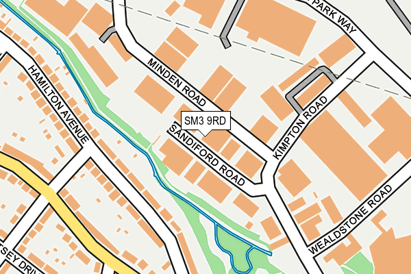
SM3 9RD is located in the Stonecot electoral ward, within the London borough of Sutton and the English Parliamentary constituency of Sutton and Cheam. The Sub Integrated Care Board (ICB) Location is NHS South West London ICB - 36L and the police force is Metropolitan Police. This postcode has been in use since January 1980.


GetTheData
Source: OS OpenMap – Local (Ordnance Survey)
Source: OS VectorMap District (Ordnance Survey)
Licence: Open Government Licence (requires attribution)
| Easting | 524616 |
| Northing | 165739 |
| Latitude | 51.377036 |
| Longitude | -0.210875 |
GetTheData
Source: Open Postcode Geo
Licence: Open Government Licence
| Country | England |
| Postcode District | SM3 |
| ➜ SM3 open data dashboard ➜ See where SM3 is on a map ➜ Where is London? | |
GetTheData
Source: Land Registry Price Paid Data
Licence: Open Government Licence
Elevation or altitude of SM3 9RD as distance above sea level:
| Metres | Feet | |
|---|---|---|
| Elevation | 30m | 98ft |
Elevation is measured from the approximate centre of the postcode, to the nearest point on an OS contour line from OS Terrain 50, which has contour spacing of ten vertical metres.
➜ How high above sea level am I? Find the elevation of your current position using your device's GPS.
GetTheData
Source: Open Postcode Elevation
Licence: Open Government Licence
| Ward | Stonecot |
| Constituency | Sutton And Cheam |
GetTheData
Source: ONS Postcode Database
Licence: Open Government Licence
| November 2023 | Vehicle crime | On or near Minden Road | 82m |
| April 2023 | Drugs | On or near Minden Road | 82m |
| February 2023 | Anti-social behaviour | On or near Minden Road | 82m |
| ➜ Get more crime data in our Crime section | |||
GetTheData
Source: data.police.uk
Licence: Open Government Licence
| Kimpton Road | Benhilton | 315m |
| Tesco Sutton Cheam | Benhilton | 341m |
| Kimpton Road | Benhilton | 355m |
| Tesco Sutton Cheam | Benhilton | 375m |
| Stayton Road | Benhilton | 516m |
| Sutton Common Station | 1km |
| West Sutton Station | 1.3km |
| St Helier (London) Station | 1.7km |
GetTheData
Source: NaPTAN
Licence: Open Government Licence
GetTheData
Source: ONS Postcode Database
Licence: Open Government Licence


➜ Get more ratings from the Food Standards Agency
GetTheData
Source: Food Standards Agency
Licence: FSA terms & conditions
| Last Collection | |||
|---|---|---|---|
| Location | Mon-Fri | Sat | Distance |
| Tesco - Instore Box | 17:15 | 12:00 | 394m |
| Oldfields Road | 17:30 | 12:00 | 634m |
| Stayton Road (142) | 17:45 | 12:00 | 646m |
GetTheData
Source: Dracos
Licence: Creative Commons Attribution-ShareAlike
| Facility | Distance |
|---|---|
| Cheam Park Farm Primary Academy Kingston Avenue, Kingston Avenue, Cheam, Sutton Artificial Grass Pitch | 613m |
| Sutton Life Centre Alcorn Close, Sutton Artificial Grass Pitch | 664m |
| Westbourne Primary School Anton Crescent, Sutton Grass Pitches | 678m |
GetTheData
Source: Active Places
Licence: Open Government Licence
| School | Phase of Education | Distance |
|---|---|---|
| Cheam Park Farm Primary Academy Molesey Drive, Cheam, Sutton, SM3 9UU | Primary | 352m |
| Brookfield Primary Academy Ridge Road, North Cheam, Sutton, SM3 9LY | Primary | 435m |
| Westbourne Primary School Anton Crescent, Collingwood Road, Sutton, SM1 2NT | Primary | 679m |
GetTheData
Source: Edubase
Licence: Open Government Licence
The below table lists the International Territorial Level (ITL) codes (formerly Nomenclature of Territorial Units for Statistics (NUTS) codes) and Local Administrative Units (LAU) codes for SM3 9RD:
| ITL 1 Code | Name |
|---|---|
| TLI | London |
| ITL 2 Code | Name |
| TLI6 | Outer London - South |
| ITL 3 Code | Name |
| TLI63 | Merton, Kingston upon Thames and Sutton |
| LAU 1 Code | Name |
| E09000029 | Sutton |
GetTheData
Source: ONS Postcode Directory
Licence: Open Government Licence
The below table lists the Census Output Area (OA), Lower Layer Super Output Area (LSOA), and Middle Layer Super Output Area (MSOA) for SM3 9RD:
| Code | Name | |
|---|---|---|
| OA | E00020812 | |
| LSOA | E01004130 | Sutton 003A |
| MSOA | E02000842 | Sutton 003 |
GetTheData
Source: ONS Postcode Directory
Licence: Open Government Licence
| SM3 9RN | Sandiford Road | 45m |
| SM3 9RL | Hamilton Avenue | 151m |
| SM3 9RJ | Hamilton Avenue | 154m |
| SM3 9QL | Kimpton Road | 162m |
| SM3 9QN | Wealdstone Road | 206m |
| SM3 9BL | Minden Road | 211m |
| SM3 9QZ | Gander Green Lane | 211m |
| SM3 9QP | Kimpton Road | 219m |
| SM3 9QS | Kimpton Park Way | 274m |
| SM3 9QY | Gander Green Lane | 277m |
GetTheData
Source: Open Postcode Geo; Land Registry Price Paid Data
Licence: Open Government Licence