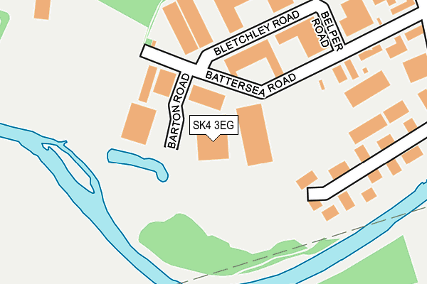
SK4 3EG lies on Barton Road in Stockport. SK4 3EG is located in the Heatons South electoral ward, within the metropolitan district of Stockport and the English Parliamentary constituency of Stockport. The Sub Integrated Care Board (ICB) Location is NHS Greater Manchester ICB - 01W and the police force is Greater Manchester. This postcode has been in use since January 1980.


GetTheData
Source: OS OpenMap – Local (Ordnance Survey)
Source: OS VectorMap District (Ordnance Survey)
Licence: Open Government Licence (requires attribution)
| Easting | 386415 |
| Northing | 390029 |
| Latitude | 53.406900 |
| Longitude | -2.205813 |
GetTheData
Source: Open Postcode Geo
Licence: Open Government Licence
| Street | Barton Road |
| Town/City | Stockport |
| Country | England |
| Postcode District | SK4 |
| ➜ SK4 open data dashboard ➜ See where SK4 is on a map ➜ Where is Stockport? | |
GetTheData
Source: Land Registry Price Paid Data
Licence: Open Government Licence
Elevation or altitude of SK4 3EG as distance above sea level:
| Metres | Feet | |
|---|---|---|
| Elevation | 30m | 98ft |
Elevation is measured from the approximate centre of the postcode, to the nearest point on an OS contour line from OS Terrain 50, which has contour spacing of ten vertical metres.
➜ How high above sea level am I? Find the elevation of your current position using your device's GPS.
GetTheData
Source: Open Postcode Elevation
Licence: Open Government Licence
| Ward | Heatons South |
| Constituency | Stockport |
GetTheData
Source: ONS Postcode Database
Licence: Open Government Licence
| Battersea Rd/Barton Rd (Battersea Rd) | Heaton Mersey | 136m |
| Battersea Rd/Blade House (Battersea Rd) | Heaton Mersey | 170m |
| Battersea Rd/Mersey House (Battersea Rd) | Heaton Mersey | 188m |
| Station Rd (Sbd) (Station Road) | Heaton Mersey | 390m |
| Craig Road (Wbd) (Craig Road) | Heaton Mersey | 505m |
| East Didsbury (Manchester Metrolink) (Kingsway) | East Didsbury | 952m |
| East Didsbury Station | 1.1km |
| Burnage Station | 1.7km |
| Gatley Station | 2.3km |
GetTheData
Source: NaPTAN
Licence: Open Government Licence
GetTheData
Source: ONS Postcode Database
Licence: Open Government Licence


➜ Get more ratings from the Food Standards Agency
GetTheData
Source: Food Standards Agency
Licence: FSA terms & conditions
| Last Collection | |||
|---|---|---|---|
| Location | Mon-Fri | Sat | Distance |
| Vale Road | 16:45 | 11:45 | 391m |
| Griffin Hotel | 16:45 | 11:45 | 586m |
| Heaton Mersey Tso | 17:15 | 12:00 | 601m |
GetTheData
Source: Dracos
Licence: Creative Commons Attribution-ShareAlike
| Facility | Distance |
|---|---|
| Burnage Rugby Football Club Battersea Road, Stockport Grass Pitches, Artificial Grass Pitch, Golf | 307m |
| Heaton Mersey Bowl Station Road, Heaton Mersey, Stockport Grass Pitches | 402m |
| Didsbury Road Primary School Didsbury Road, Stockport Grass Pitches | 718m |
GetTheData
Source: Active Places
Licence: Open Government Licence
| School | Phase of Education | Distance |
|---|---|---|
| Stella Maris School St John's Road, Heaton Mersey, Stockport, SK4 3BR | Not applicable | 687m |
| Didsbury Road Primary School Didsbury Road, Heaton Mersey, Didsbury Road Primary School, Stockport, SK4 3HB | Primary | 718m |
| St John's Church of England Primary School Poplar Street, Heaton Mersey, Stockport, SK4 3DG | Primary | 800m |
GetTheData
Source: Edubase
Licence: Open Government Licence
| Risk of SK4 3EG flooding from rivers and sea | Medium |
| ➜ SK4 3EG flood map | |
GetTheData
Source: Open Flood Risk by Postcode
Licence: Open Government Licence
The below table lists the International Territorial Level (ITL) codes (formerly Nomenclature of Territorial Units for Statistics (NUTS) codes) and Local Administrative Units (LAU) codes for SK4 3EG:
| ITL 1 Code | Name |
|---|---|
| TLD | North West (England) |
| ITL 2 Code | Name |
| TLD3 | Greater Manchester |
| ITL 3 Code | Name |
| TLD35 | Greater Manchester South East |
| LAU 1 Code | Name |
| E08000007 | Stockport |
GetTheData
Source: ONS Postcode Directory
Licence: Open Government Licence
The below table lists the Census Output Area (OA), Lower Layer Super Output Area (LSOA), and Middle Layer Super Output Area (MSOA) for SK4 3EG:
| Code | Name | |
|---|---|---|
| OA | E00029641 | |
| LSOA | E01005852 | Stockport 013A |
| MSOA | E02001199 | Stockport 013 |
GetTheData
Source: ONS Postcode Directory
Licence: Open Government Licence
| SK4 3EJ | Bletchley Road | 201m |
| SK4 3GN | Riverview | 236m |
| SK4 3EX | Station Road | 444m |
| SK4 3BD | Meltham Close | 469m |
| SK4 3RB | Green Pastures | 495m |
| SK4 3AS | Didsbury Road | 505m |
| SK4 3RA | Green Pastures | 514m |
| SK4 3DY | Park Row | 517m |
| SK4 3DZ | Park Place | 537m |
| SK4 2BW | Craig Road | 541m |
GetTheData
Source: Open Postcode Geo; Land Registry Price Paid Data
Licence: Open Government Licence