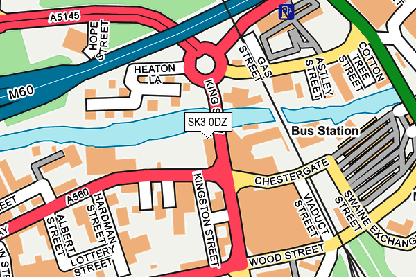
SK3 0DZ is located in the Edgeley electoral ward, within the metropolitan district of Stockport and the English Parliamentary constituency of Stockport. The Sub Integrated Care Board (ICB) Location is NHS Greater Manchester ICB - 01W and the police force is Greater Manchester. This postcode has been in use since May 1994.


GetTheData
Source: OS OpenMap – Local (Ordnance Survey)
Source: OS VectorMap District (Ordnance Survey)
Licence: Open Government Licence (requires attribution)
| Easting | 388990 |
| Northing | 390247 |
| Latitude | 53.408936 |
| Longitude | -2.167086 |
GetTheData
Source: Open Postcode Geo
Licence: Open Government Licence
| Country | England |
| Postcode District | SK3 |
| ➜ SK3 open data dashboard ➜ See where SK3 is on a map ➜ Where is Stockport? | |
GetTheData
Source: Land Registry Price Paid Data
Licence: Open Government Licence
Elevation or altitude of SK3 0DZ as distance above sea level:
| Metres | Feet | |
|---|---|---|
| Elevation | 40m | 131ft |
Elevation is measured from the approximate centre of the postcode, to the nearest point on an OS contour line from OS Terrain 50, which has contour spacing of ten vertical metres.
➜ How high above sea level am I? Find the elevation of your current position using your device's GPS.
GetTheData
Source: Open Postcode Elevation
Licence: Open Government Licence
| Ward | Edgeley |
| Constituency | Stockport |
GetTheData
Source: ONS Postcode Database
Licence: Open Government Licence
| October 2021 | Possession of weapons | On or near Pedestrian Subway | 458m |
| ➜ Get more crime data in our Crime section | |||
GetTheData
Source: data.police.uk
Licence: Open Government Licence
| Chestergate/Chester St (Chestergate) | Stockport | 218m |
| Wood Street/Hollywood Park (Wood Street) | Stockport | 278m |
| Wellington Rd North/Leyland St (Wellington Rd N) | Stockport | 284m |
| Wellington Rd Nth/Railway St (Wellington Rd N) | Stockport | 298m |
| Mersey Square/Merseyway Precinct (Mersey Square) | Stockport | 305m |
| Stockport Station | 0.5km |
| Heaton Chapel Station | 2km |
| Davenport Station | 2.2km |
GetTheData
Source: NaPTAN
Licence: Open Government Licence
GetTheData
Source: ONS Postcode Database
Licence: Open Government Licence


➜ Get more ratings from the Food Standards Agency
GetTheData
Source: Food Standards Agency
Licence: FSA terms & conditions
| Last Collection | |||
|---|---|---|---|
| Location | Mon-Fri | Sat | Distance |
| Regent House | 17:30 | 12:30 | 225m |
| Chestergate | 17:30 | 12:15 | 249m |
| Exchange Street | 19:00 | 363m | |
GetTheData
Source: Dracos
Licence: Creative Commons Attribution-ShareAlike
| Facility | Distance |
|---|---|
| Reflections (Closed) Heaton Lane, Stockport Health and Fitness Gym | 172m |
| Hollywood Park Lottery Street, Stockport Grass Pitches | 368m |
| The Gym Group (Stockport) Bridgefield Street, Bridgefield Street, Stockport Health and Fitness Gym | 378m |
GetTheData
Source: Active Places
Licence: Open Government Licence
| School | Phase of Education | Distance |
|---|---|---|
| Progress Schools - Stockport Belgrave House, 211 Chestergate, Stockport, SK3 0AN | Not applicable | 133m |
| Hollywood Park Nursery School Hardman Street, Chestergate, Stockport, SK3 0BJ | Nursery | 187m |
| Pure Innovations Trading As Pure College 1 Exchange Street, Stockport, SK3 0GA | Not applicable | 398m |
GetTheData
Source: Edubase
Licence: Open Government Licence
| Risk of SK3 0DZ flooding from rivers and sea | Low |
| ➜ SK3 0DZ flood map | |
GetTheData
Source: Open Flood Risk by Postcode
Licence: Open Government Licence
The below table lists the International Territorial Level (ITL) codes (formerly Nomenclature of Territorial Units for Statistics (NUTS) codes) and Local Administrative Units (LAU) codes for SK3 0DZ:
| ITL 1 Code | Name |
|---|---|
| TLD | North West (England) |
| ITL 2 Code | Name |
| TLD3 | Greater Manchester |
| ITL 3 Code | Name |
| TLD35 | Greater Manchester South East |
| LAU 1 Code | Name |
| E08000007 | Stockport |
GetTheData
Source: ONS Postcode Directory
Licence: Open Government Licence
The below table lists the Census Output Area (OA), Lower Layer Super Output Area (LSOA), and Middle Layer Super Output Area (MSOA) for SK3 0DZ:
| Code | Name | |
|---|---|---|
| OA | E00029487 | |
| LSOA | E01005822 | Stockport 016D |
| MSOA | E02001202 | Stockport 016 |
GetTheData
Source: ONS Postcode Directory
Licence: Open Government Licence
| SK3 0AN | Chestergate | 143m |
| SK3 0BG | Owen Street | 169m |
| SK4 1AQ | Heaton Lane | 186m |
| SK3 0BN | Lottery Street | 245m |
| SK3 0HW | 285m | |
| SK3 0EU | Wellington Road South | 330m |
| SK3 0DN | Hilton Street | 339m |
| SK3 0DE | Hilton Court | 341m |
| SK1 1RB | Princes Street | 347m |
| SK4 1AA | Wellington Road South | 351m |
GetTheData
Source: Open Postcode Geo; Land Registry Price Paid Data
Licence: Open Government Licence