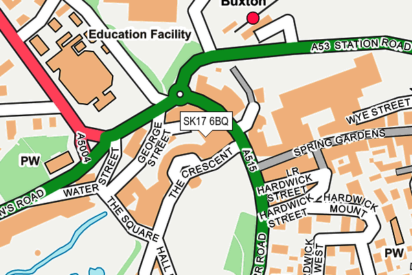
SK17 6BQ is located in the Buxton Central electoral ward, within the local authority district of High Peak and the English Parliamentary constituency of High Peak. The Sub Integrated Care Board (ICB) Location is NHS Derby and Derbyshire ICB - 15M and the police force is Derbyshire. This postcode has been in use since January 1980.


GetTheData
Source: OS OpenMap – Local (Ordnance Survey)
Source: OS VectorMap District (Ordnance Survey)
Licence: Open Government Licence (requires attribution)
| Easting | 405827 |
| Northing | 373591 |
| Latitude | 53.259307 |
| Longitude | -1.914109 |
GetTheData
Source: Open Postcode Geo
Licence: Open Government Licence
| Country | England |
| Postcode District | SK17 |
| ➜ SK17 open data dashboard ➜ See where SK17 is on a map ➜ Where is Buxton? | |
GetTheData
Source: Land Registry Price Paid Data
Licence: Open Government Licence
Elevation or altitude of SK17 6BQ as distance above sea level:
| Metres | Feet | |
|---|---|---|
| Elevation | 290m | 951ft |
Elevation is measured from the approximate centre of the postcode, to the nearest point on an OS contour line from OS Terrain 50, which has contour spacing of ten vertical metres.
➜ How high above sea level am I? Find the elevation of your current position using your device's GPS.
GetTheData
Source: Open Postcode Elevation
Licence: Open Government Licence
| Ward | Buxton Central |
| Constituency | High Peak |
GetTheData
Source: ONS Postcode Database
Licence: Open Government Licence
| January 2024 | Violence and sexual offences | On or near Parking Area | 225m |
| January 2024 | Burglary | On or near Parking Area | 410m |
| January 2024 | Criminal damage and arson | On or near Parking Area | 410m |
| ➜ Get more crime data in our Crime section | |||
GetTheData
Source: data.police.uk
Licence: Open Government Licence
| Colonnade (The Quadrant) | Buxton | 37m |
| Terrace Road | Buxton | 122m |
| Terrace Road | Buxton | 125m |
| Railway Station (Station Road) | Buxton | 140m |
| University Campus (Devonshire Road) | Buxton | 144m |
| Buxton Station | 0.2km |
| Dove Holes Station | 4.8km |
GetTheData
Source: NaPTAN
Licence: Open Government Licence
GetTheData
Source: ONS Postcode Database
Licence: Open Government Licence


➜ Get more ratings from the Food Standards Agency
GetTheData
Source: Food Standards Agency
Licence: FSA terms & conditions
| Last Collection | |||
|---|---|---|---|
| Location | Mon-Fri | Sat | Distance |
| Quadrant | 18:00 | 12:30 | 60m |
| Pavillion | 17:45 | 11:15 | 166m |
| Hardwick Mount | 17:30 | 11:15 | 220m |
GetTheData
Source: Dracos
Licence: Creative Commons Attribution-ShareAlike
| Facility | Distance |
|---|---|
| University Of Derby (Buxton Campus) (Closed) Devonshire Road, Buxton Sports Hall, Health and Fitness Gym | 187m |
| Spindles At The Palace Hotel (Buxton) Palace Road, Buxton Health and Fitness Gym, Swimming Pool, Studio | 207m |
| St Thomas More Catholic School Palace Road, Buxton Sports Hall, Studio | 359m |
GetTheData
Source: Active Places
Licence: Open Government Licence
| School | Phase of Education | Distance |
|---|---|---|
| Buxton and Leek College Devonshire Road, Buxton, SK17 6RY | Not applicable | 187m |
| Buxton Infant School Hardwick Square, Buxton, SK17 6QB | Primary | 334m |
| St Thomas More Catholic Voluntary Academy Palace Fields, Buxton, SK17 6AF | Secondary | 359m |
GetTheData
Source: Edubase
Licence: Open Government Licence
| Risk of SK17 6BQ flooding from rivers and sea | Medium |
| ➜ SK17 6BQ flood map | |
GetTheData
Source: Open Flood Risk by Postcode
Licence: Open Government Licence
The below table lists the International Territorial Level (ITL) codes (formerly Nomenclature of Territorial Units for Statistics (NUTS) codes) and Local Administrative Units (LAU) codes for SK17 6BQ:
| ITL 1 Code | Name |
|---|---|
| TLF | East Midlands (England) |
| ITL 2 Code | Name |
| TLF1 | Derbyshire and Nottinghamshire |
| ITL 3 Code | Name |
| TLF13 | South and West Derbyshire |
| LAU 1 Code | Name |
| E07000037 | High Peak |
GetTheData
Source: ONS Postcode Directory
Licence: Open Government Licence
The below table lists the Census Output Area (OA), Lower Layer Super Output Area (LSOA), and Middle Layer Super Output Area (MSOA) for SK17 6BQ:
| Code | Name | |
|---|---|---|
| OA | E00099752 | |
| LSOA | E01019717 | High Peak 010C |
| MSOA | E02004102 | High Peak 010 |
GetTheData
Source: ONS Postcode Directory
Licence: Open Government Licence
| SK17 6AL | The Colonnade | 26m |
| SK17 6AT | Cavendish Circus | 50m |
| SK17 6AW | The Quadrant | 59m |
| SK17 6AJ | Grove Parade | 77m |
| SK17 6AH | Station Approach | 96m |
| SK17 6DR | Terrace Road | 119m |
| SK17 6AZ | The Square | 139m |
| SK17 6DE | Spring Gardens | 151m |
| SK17 6DF | Spring Gardens Centre | 151m |
| SK17 6DH | Hardwick Street | 167m |
GetTheData
Source: Open Postcode Geo; Land Registry Price Paid Data
Licence: Open Government Licence