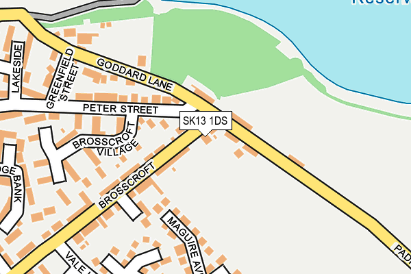
SK13 1DS is located in the Padfield electoral ward, within the local authority district of High Peak and the English Parliamentary constituency of High Peak. The Sub Integrated Care Board (ICB) Location is NHS Derby and Derbyshire ICB - 15M and the police force is Derbyshire. This postcode has been in use since December 1997.


GetTheData
Source: OS OpenMap – Local (Ordnance Survey)
Source: OS VectorMap District (Ordnance Survey)
Licence: Open Government Licence (requires attribution)
| Easting | 402417 |
| Northing | 396714 |
| Latitude | 53.467161 |
| Longitude | -1.965059 |
GetTheData
Source: Open Postcode Geo
Licence: Open Government Licence
| Country | England |
| Postcode District | SK13 |
| ➜ SK13 open data dashboard ➜ See where SK13 is on a map ➜ Where is Hadfield? | |
GetTheData
Source: Land Registry Price Paid Data
Licence: Open Government Licence
Elevation or altitude of SK13 1DS as distance above sea level:
| Metres | Feet | |
|---|---|---|
| Elevation | 170m | 558ft |
Elevation is measured from the approximate centre of the postcode, to the nearest point on an OS contour line from OS Terrain 50, which has contour spacing of ten vertical metres.
➜ How high above sea level am I? Find the elevation of your current position using your device's GPS.
GetTheData
Source: Open Postcode Elevation
Licence: Open Government Licence
| Ward | Padfield |
| Constituency | High Peak |
GetTheData
Source: ONS Postcode Database
Licence: Open Government Licence
| May 2023 | Anti-social behaviour | On or near Maguire Avenue | 182m |
| May 2023 | Public order | On or near Parking Area | 486m |
| September 2022 | Violence and sexual offences | On or near Maguire Avenue | 182m |
| ➜ Get more crime data in our Crime section | |||
GetTheData
Source: data.police.uk
Licence: Open Government Licence
| Medical Centre (Brosscroft) | Hadfield | 42m |
| Medical Centre (Brosscroft) | Hadfield | 50m |
| 75 Padfield Main Road (Padfield Main Road) | Hadfield | 132m |
| 75 Padfield Main Road (Padfield Main Road) | Hadfield | 132m |
| Greenfield Street (Peter Street) | Hadfield | 192m |
| Hadfield Station | 0.7km |
| Dinting Station | 2km |
| Glossop Station | 2.7km |
GetTheData
Source: NaPTAN
Licence: Open Government Licence
GetTheData
Source: ONS Postcode Database
Licence: Open Government Licence


➜ Get more ratings from the Food Standards Agency
GetTheData
Source: Food Standards Agency
Licence: FSA terms & conditions
| Last Collection | |||
|---|---|---|---|
| Location | Mon-Fri | Sat | Distance |
| Brosscroft | 17:30 | 12:00 | 30m |
| Malvern Rise | 17:45 | 11:45 | 447m |
| 120 Station Road | 18:00 | 12:30 | 570m |
GetTheData
Source: Dracos
Licence: Creative Commons Attribution-ShareAlike
| Facility | Distance |
|---|---|
| Hadfield Playing Field Padfield Main Road, Hadfield, Glossop Grass Pitches | 327m |
| Tintwistle C Of E Primary School South Close, Tintwistle, Glossop Grass Pitches | 896m |
| St Andrew C Of E Junior School Hadfield Road, Hadfield, Glossop Grass Pitches | 904m |
GetTheData
Source: Active Places
Licence: Open Government Licence
| School | Phase of Education | Distance |
|---|---|---|
| Padfield Community Primary School Rhodes Street, Padfield, Glossop, SK13 1EQ | Primary | 686m |
| Tintwistle CofE (Aided) Primary School South Close, Tintwistle, Glossop, SK13 1LY | Primary | 819m |
| Hadfield Infant School Mersey Bank Road, Hadfield, Glossop, SK13 1PN | Primary | 890m |
GetTheData
Source: Edubase
Licence: Open Government Licence
The below table lists the International Territorial Level (ITL) codes (formerly Nomenclature of Territorial Units for Statistics (NUTS) codes) and Local Administrative Units (LAU) codes for SK13 1DS:
| ITL 1 Code | Name |
|---|---|
| TLF | East Midlands (England) |
| ITL 2 Code | Name |
| TLF1 | Derbyshire and Nottinghamshire |
| ITL 3 Code | Name |
| TLF13 | South and West Derbyshire |
| LAU 1 Code | Name |
| E07000037 | High Peak |
GetTheData
Source: ONS Postcode Directory
Licence: Open Government Licence
The below table lists the Census Output Area (OA), Lower Layer Super Output Area (LSOA), and Middle Layer Super Output Area (MSOA) for SK13 1DS:
| Code | Name | |
|---|---|---|
| OA | E00099942 | |
| LSOA | E01019752 | High Peak 001B |
| MSOA | E02004093 | High Peak 001 |
GetTheData
Source: ONS Postcode Directory
Licence: Open Government Licence
| SK13 1HE | Brosscroft | 44m |
| SK13 1EZ | Padfield Main Road | 63m |
| SK13 1HA | Padfield Main Road | 69m |
| SK13 1HD | Peter Street | 121m |
| SK13 1GA | Brosscroft Close | 139m |
| SK13 1HH | Brosscroft Village | 164m |
| SK13 1HF | Brosscroft | 169m |
| SK13 1HQ | Brosscroft Village | 213m |
| SK13 1HB | Greenfield Street | 217m |
| SK13 1HJ | Goddard Lane | 221m |
GetTheData
Source: Open Postcode Geo; Land Registry Price Paid Data
Licence: Open Government Licence