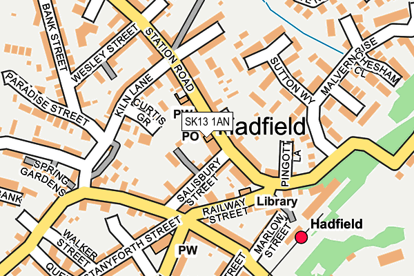
SK13 1AN lies on Station Road in Hadfield, Glossop. SK13 1AN is located in the Hadfield North electoral ward, within the local authority district of High Peak and the English Parliamentary constituency of High Peak. The Sub Integrated Care Board (ICB) Location is NHS Derby and Derbyshire ICB - 15M and the police force is Derbyshire. This postcode has been in use since December 2000.


GetTheData
Source: OS OpenMap – Local (Ordnance Survey)
Source: OS VectorMap District (Ordnance Survey)
Licence: Open Government Licence (requires attribution)
| Easting | 402258 |
| Northing | 396151 |
| Latitude | 53.462101 |
| Longitude | -1.967458 |
GetTheData
Source: Open Postcode Geo
Licence: Open Government Licence
| Street | Station Road |
| Locality | Hadfield |
| Town/City | Glossop |
| Country | England |
| Postcode District | SK13 |
| ➜ SK13 open data dashboard ➜ See where SK13 is on a map ➜ Where is Hadfield? | |
GetTheData
Source: Land Registry Price Paid Data
Licence: Open Government Licence
Elevation or altitude of SK13 1AN as distance above sea level:
| Metres | Feet | |
|---|---|---|
| Elevation | 170m | 558ft |
Elevation is measured from the approximate centre of the postcode, to the nearest point on an OS contour line from OS Terrain 50, which has contour spacing of ten vertical metres.
➜ How high above sea level am I? Find the elevation of your current position using your device's GPS.
GetTheData
Source: Open Postcode Elevation
Licence: Open Government Licence
| Ward | Hadfield North |
| Constituency | High Peak |
GetTheData
Source: ONS Postcode Database
Licence: Open Government Licence
| May 2023 | Public order | On or near Parking Area | 241m |
| May 2023 | Anti-social behaviour | On or near Maguire Avenue | 407m |
| September 2022 | Violence and sexual offences | On or near Maguire Avenue | 407m |
| ➜ Station Road crime map and outcomes | |||
GetTheData
Source: data.police.uk
Licence: Open Government Licence
| Railway Station (Station Road) | Hadfield | 93m |
| Masons Arms (Station Road) | Hadfield | 105m |
| Railway Station (Station Road) | Hadfield | 109m |
| St Andrews Church (Church Street) | Hadfield | 153m |
| Masons Arms (Station Road) | Hadfield | 168m |
| Hadfield Station | 0.2km |
| Dinting Station | 1.4km |
| Glossop Station | 2.3km |
GetTheData
Source: NaPTAN
Licence: Open Government Licence
GetTheData
Source: ONS Postcode Database
Licence: Open Government Licence


➜ Get more ratings from the Food Standards Agency
GetTheData
Source: Food Standards Agency
Licence: FSA terms & conditions
| Last Collection | |||
|---|---|---|---|
| Location | Mon-Fri | Sat | Distance |
| 120 Station Road | 18:00 | 12:30 | 15m |
| Malvern Rise | 17:45 | 11:45 | 234m |
| Queen Street | 17:45 | 12:30 | 304m |
GetTheData
Source: Dracos
Licence: Creative Commons Attribution-ShareAlike
| Facility | Distance |
|---|---|
| St Andrew C Of E Junior School Hadfield Road, Hadfield, Glossop Grass Pitches | 360m |
| The Hadfield Centre (Closed) Newshaw Lane, Hadfield, Glossop Sports Hall | 549m |
| Hadfield Playing Field Padfield Main Road, Hadfield, Glossop Grass Pitches | 576m |
GetTheData
Source: Active Places
Licence: Open Government Licence
| School | Phase of Education | Distance |
|---|---|---|
| St Andrew's CofE Junior School Hadfield Road, Hadfield, Glossop, SK13 2DR | Primary | 360m |
| Hadfield Nursery School Queen Street, Hadfield, Glossop, SK13 2DW | Nursery | 376m |
| Hadfield Infant School Mersey Bank Road, Hadfield, Glossop, SK13 1PN | Primary | 387m |
GetTheData
Source: Edubase
Licence: Open Government Licence
The below table lists the International Territorial Level (ITL) codes (formerly Nomenclature of Territorial Units for Statistics (NUTS) codes) and Local Administrative Units (LAU) codes for SK13 1AN:
| ITL 1 Code | Name |
|---|---|
| TLF | East Midlands (England) |
| ITL 2 Code | Name |
| TLF1 | Derbyshire and Nottinghamshire |
| ITL 3 Code | Name |
| TLF13 | South and West Derbyshire |
| LAU 1 Code | Name |
| E07000037 | High Peak |
GetTheData
Source: ONS Postcode Directory
Licence: Open Government Licence
The below table lists the Census Output Area (OA), Lower Layer Super Output Area (LSOA), and Middle Layer Super Output Area (MSOA) for SK13 1AN:
| Code | Name | |
|---|---|---|
| OA | E00099826 | |
| LSOA | E01019730 | High Peak 002C |
| MSOA | E02004094 | High Peak 002 |
GetTheData
Source: ONS Postcode Directory
Licence: Open Government Licence
| SK13 1AJ | Station Road | 40m |
| SK13 1NP | Salisbury Street | 56m |
| SK13 1AA | Station Road | 66m |
| SK13 2BF | Kingsmoor Court | 75m |
| SK13 1AR | Station Road | 77m |
| SK13 1AE | Curtis Grove | 78m |
| SK13 1QR | Langley Court | 108m |
| SK13 2AA | Railway Street | 116m |
| SK13 1QP | Evesham Avenue | 127m |
| SK13 1AT | Lambgates | 132m |
GetTheData
Source: Open Postcode Geo; Land Registry Price Paid Data
Licence: Open Government Licence