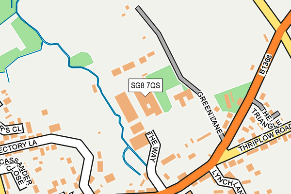
SG8 7QS is located in the Foxton electoral ward, within the local authority district of South Cambridgeshire and the English Parliamentary constituency of South Cambridgeshire. The Sub Integrated Care Board (ICB) Location is NHS Cambridgeshire and Peterborough ICB - 06H and the police force is Cambridgeshire. This postcode has been in use since January 1980.


GetTheData
Source: OS OpenMap – Local (Ordnance Survey)
Source: OS VectorMap District (Ordnance Survey)
Licence: Open Government Licence (requires attribution)
| Easting | 542310 |
| Northing | 246162 |
| Latitude | 52.095505 |
| Longitude | 0.076022 |
GetTheData
Source: Open Postcode Geo
Licence: Open Government Licence
| Country | England |
| Postcode District | SG8 |
| ➜ SG8 open data dashboard ➜ See where SG8 is on a map ➜ Where is Fowlmere? | |
GetTheData
Source: Land Registry Price Paid Data
Licence: Open Government Licence
Elevation or altitude of SG8 7QS as distance above sea level:
| Metres | Feet | |
|---|---|---|
| Elevation | 30m | 98ft |
Elevation is measured from the approximate centre of the postcode, to the nearest point on an OS contour line from OS Terrain 50, which has contour spacing of ten vertical metres.
➜ How high above sea level am I? Find the elevation of your current position using your device's GPS.
GetTheData
Source: Open Postcode Elevation
Licence: Open Government Licence
| Ward | Foxton |
| Constituency | South Cambridgeshire |
GetTheData
Source: ONS Postcode Database
Licence: Open Government Licence
| February 2023 | Violence and sexual offences | On or near Rectory Lane | 242m |
| February 2023 | Violence and sexual offences | On or near Rectory Lane | 242m |
| December 2022 | Violence and sexual offences | On or near Rectory Lane | 242m |
| ➜ Get more crime data in our Crime section | |||
GetTheData
Source: data.police.uk
Licence: Open Government Licence
| Cambridge Road (Thriplow Road) | Fowlmere | 213m |
| The Butts (High Street) | Fowlmere | 382m |
| The Butts (High Street) | Fowlmere | 430m |
| Chapel Lane (London Road) | Fowlmere | 585m |
| Chapel Lane (London Road) | Fowlmere | 626m |
| Foxton Station | 3km |
| Shepreth Station | 3.7km |
| Meldreth Station | 4.6km |
GetTheData
Source: NaPTAN
Licence: Open Government Licence
GetTheData
Source: ONS Postcode Database
Licence: Open Government Licence


➜ Get more ratings from the Food Standards Agency
GetTheData
Source: Food Standards Agency
Licence: FSA terms & conditions
| Last Collection | |||
|---|---|---|---|
| Location | Mon-Fri | Sat | Distance |
| High Street | 16:20 | 10:00 | 211m |
| London Road | 16:00 | 10:00 | 877m |
| Thriplow | 16:30 | 10:30 | 1,553m |
GetTheData
Source: Dracos
Licence: Creative Commons Attribution-ShareAlike
| Facility | Distance |
|---|---|
| Fowlmere Recreation Ground Chrishall Road, Fowlmere Grass Pitches, Sports Hall, Outdoor Tennis Courts | 885m |
| Thriplow Cricket Club Fowlmere Road, Thriplow Grass Pitches | 1.3km |
| Foxton Recreation Ground Hardman Road, Foxton, Cambridge Grass Pitches, Outdoor Tennis Courts | 2.3km |
GetTheData
Source: Active Places
Licence: Open Government Licence
| School | Phase of Education | Distance |
|---|---|---|
| Fowlmere Primary School The Butts, Fowlmere, Royston, SG8 7SL | Primary | 442m |
| Thriplow CofE Primary School School Lane, Thriplow, Royston, SG8 7RH | Primary | 1.9km |
| Foxton Primary School 11 Hardman Road, Foxton, Cambridge, CB22 6RN | Primary | 2.4km |
GetTheData
Source: Edubase
Licence: Open Government Licence
| Risk of SG8 7QS flooding from rivers and sea | Medium |
| ➜ SG8 7QS flood map | |
GetTheData
Source: Open Flood Risk by Postcode
Licence: Open Government Licence
The below table lists the International Territorial Level (ITL) codes (formerly Nomenclature of Territorial Units for Statistics (NUTS) codes) and Local Administrative Units (LAU) codes for SG8 7QS:
| ITL 1 Code | Name |
|---|---|
| TLH | East |
| ITL 2 Code | Name |
| TLH1 | East Anglia |
| ITL 3 Code | Name |
| TLH12 | Cambridgeshire CC |
| LAU 1 Code | Name |
| E07000012 | South Cambridgeshire |
GetTheData
Source: ONS Postcode Directory
Licence: Open Government Licence
The below table lists the Census Output Area (OA), Lower Layer Super Output Area (LSOA), and Middle Layer Super Output Area (MSOA) for SG8 7QS:
| Code | Name | |
|---|---|---|
| OA | E00092012 | |
| LSOA | E01018241 | South Cambridgeshire 018A |
| MSOA | E02003792 | South Cambridgeshire 018 |
GetTheData
Source: ONS Postcode Directory
Licence: Open Government Licence
| SG8 7SU | High Street | 162m |
| SG8 7QN | Cambridge Road | 176m |
| SG8 7QP | Green Lane | 210m |
| SG8 7TL | Rectory Lane | 212m |
| SG8 7ST | High Street | 212m |
| SG8 7TJ | Rectory Lane | 241m |
| SG8 7SX | Lynch Lane | 263m |
| SG8 7QT | Thriplow Road | 264m |
| SG8 7SW | New Farm Close | 265m |
| SG8 7WA | Aldous Court | 268m |
GetTheData
Source: Open Postcode Geo; Land Registry Price Paid Data
Licence: Open Government Licence