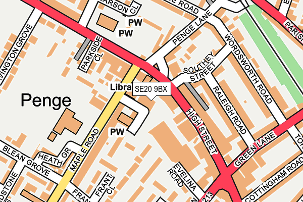
SE20 9BX is located in the Penge & Cator electoral ward, within the London borough of Bromley and the English Parliamentary constituency of Lewisham West and Penge. The Sub Integrated Care Board (ICB) Location is NHS South East London ICB - 72Q and the police force is Metropolitan Police. This postcode has been in use since July 2023.


GetTheData
Source: OS OpenMap – Local (Ordnance Survey)
Source: OS VectorMap District (Ordnance Survey)
Licence: Open Government Licence (requires attribution)
| Easting | 535441 |
| Northing | 170262 |
| Latitude | 51.415205 |
| Longitude | -0.053708 |
GetTheData
Source: Open Postcode Geo
Licence: Open Government Licence
| Country | England |
| Postcode District | SE20 |
| ➜ SE20 open data dashboard ➜ See where SE20 is on a map ➜ Where is Penge? | |
GetTheData
Source: Land Registry Price Paid Data
Licence: Open Government Licence
Elevation or altitude of SE20 9BX as distance above sea level:
| Metres | Feet | |
|---|---|---|
| Elevation | 40m | 131ft |
Elevation is measured from the approximate centre of the postcode, to the nearest point on an OS contour line from OS Terrain 50, which has contour spacing of ten vertical metres.
➜ How high above sea level am I? Find the elevation of your current position using your device's GPS.
GetTheData
Source: Open Postcode Elevation
Licence: Open Government Licence
| Ward | Penge & Cator |
| Constituency | Lewisham West And Penge |
GetTheData
Source: ONS Postcode Database
Licence: Open Government Licence
| January 2024 | Other theft | On or near Bycroft Street | 246m |
| September 2023 | Other theft | On or near Bycroft Street | 246m |
| August 2023 | Anti-social behaviour | On or near Bycroft Street | 246m |
| ➜ Get more crime data in our Crime section | |||
GetTheData
Source: data.police.uk
Licence: Open Government Licence
| Penge Crooked Billet (Penge High Street) | Penge & Sydenham | 46m |
| High Street Maple Road | Penge & Sydenham | 55m |
| High Street Maple Road | Penge & Sydenham | 107m |
| High Street Green Lane (Penge High Street) | Penge & Sydenham | 128m |
| Penge Pawleyne Arms (Croydon Road) | Penge & Sydenham | 195m |
| Beckenham Road Tram Stop (Beckenham Road) | Penge & Sydenham | 956m |
| Avenue Road Tram Stop (Avenue Road) | Penge & Sydenham | 981m |
| Birkbeck Tram Stop (Elmers End Road) | Anerley | 1,281m |
| Penge East Station | 0.5km |
| Penge West Station | 0.6km |
| Kent House Station | 0.7km |
GetTheData
Source: NaPTAN
Licence: Open Government Licence
GetTheData
Source: ONS Postcode Database
Licence: Open Government Licence


➜ Get more ratings from the Food Standards Agency
GetTheData
Source: Food Standards Agency
Licence: FSA terms & conditions
| Last Collection | |||
|---|---|---|---|
| Location | Mon-Fri | Sat | Distance |
| Post Office | 17:30 | 12:00 | 25m |
| Post Office | 17:30 | 12:00 | 58m |
| Parish Lane | 17:30 | 12:00 | 321m |
GetTheData
Source: Dracos
Licence: Creative Commons Attribution-ShareAlike
| Facility | Distance |
|---|---|
| Harris Primary Academy Crystal Palace Malcolm Road, London Grass Pitches | 384m |
| Royston Field Franklin Road, Penge, London Grass Pitches | 426m |
| Harris Primary Academy Kent House High Street, London Grass Pitches | 478m |
GetTheData
Source: Active Places
Licence: Open Government Licence
| School | Phase of Education | Distance |
|---|---|---|
| St John's Church of England Primary School Maple Road, Penge, London, SE20 8HU | Primary | 102m |
| Harris Primary Academy Crystal Palace Malcolm Road, Penge, London, SE20 8RH | Primary | 385m |
| Harris Primary Academy Kent House High Street, Penge, London, SE20 7QR | Primary | 478m |
GetTheData
Source: Edubase
Licence: Open Government Licence
The below table lists the International Territorial Level (ITL) codes (formerly Nomenclature of Territorial Units for Statistics (NUTS) codes) and Local Administrative Units (LAU) codes for SE20 9BX:
| ITL 1 Code | Name |
|---|---|
| TLI | London |
| ITL 2 Code | Name |
| TLI6 | Outer London - South |
| ITL 3 Code | Name |
| TLI61 | Bromley |
| LAU 1 Code | Name |
| E09000006 | Bromley |
GetTheData
Source: ONS Postcode Directory
Licence: Open Government Licence
The below table lists the Census Output Area (OA), Lower Layer Super Output Area (LSOA), and Middle Layer Super Output Area (MSOA) for SE20 9BX:
| Code | Name | |
|---|---|---|
| OA | E00003925 | |
| LSOA | E01000799 | Bromley 004A |
| MSOA | E02000130 | Bromley 004 |
GetTheData
Source: ONS Postcode Directory
Licence: Open Government Licence
| SE20 7EZ | High Street | 25m |
| SE20 8HR | Blenheim Road | 46m |
| SE20 8HT | Maple Road | 47m |
| SE20 7DT | High Street | 79m |
| SE20 7EX | High Street | 95m |
| SE20 8HX | Maple Road | 96m |
| SE20 8JF | Burham Close | 98m |
| SE20 8HU | Maple Road | 102m |
| SE20 7DS | High Street | 102m |
| SE20 7JD | Southey Street | 120m |
GetTheData
Source: Open Postcode Geo; Land Registry Price Paid Data
Licence: Open Government Licence