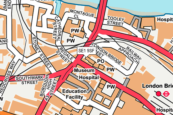
SE1 9SF is located in the London Bridge & West Bermondsey electoral ward, within the London borough of Southwark and the English Parliamentary constituency of Bermondsey and Old Southwark. The Sub Integrated Care Board (ICB) Location is NHS South East London ICB - 72Q and the police force is Metropolitan Police. This postcode has been in use since January 1980.


GetTheData
Source: OS OpenMap – Local (Ordnance Survey)
Source: OS VectorMap District (Ordnance Survey)
Licence: Open Government Licence (requires attribution)
| Easting | 532729 |
| Northing | 180216 |
| Latitude | 51.505298 |
| Longitude | -0.088977 |
GetTheData
Source: Open Postcode Geo
Licence: Open Government Licence
| Country | England |
| Postcode District | SE1 |
| ➜ SE1 open data dashboard ➜ See where SE1 is on a map ➜ Where is Bermondsey? | |
GetTheData
Source: Land Registry Price Paid Data
Licence: Open Government Licence
Elevation or altitude of SE1 9SF as distance above sea level:
| Metres | Feet | |
|---|---|---|
| Elevation | 10m | 33ft |
Elevation is measured from the approximate centre of the postcode, to the nearest point on an OS contour line from OS Terrain 50, which has contour spacing of ten vertical metres.
➜ How high above sea level am I? Find the elevation of your current position using your device's GPS.
GetTheData
Source: Open Postcode Elevation
Licence: Open Government Licence
| Ward | London Bridge & West Bermondsey |
| Constituency | Bermondsey And Old Southwark |
GetTheData
Source: ONS Postcode Database
Licence: Open Government Licence
| January 2024 | Other theft | On or near Montague Close | 106m |
| January 2024 | Other theft | On or near Montague Close | 106m |
| January 2024 | Burglary | On or near Clink Street | 271m |
| ➜ Get more crime data in our Crime section | |||
GetTheData
Source: data.police.uk
Licence: Open Government Licence
| London Bridge Bus Station (London Bridge Street) | London Bridge | 109m |
| London Bridge Station (Railway Approach) | London Bridge | 125m |
| London Bridge Station (Duke Street Hill) | London Bridge | 134m |
| London Bridge Bus Station | London Bridge | 145m |
| London Bridge Borough High St | London Bridge | 150m |
| London Bridge Underground Station | London Bridge | 47m |
| Borough Underground Station | The Borough | 549m |
| Monument Underground Station | Monument | 636m |
| Cannon Street Underground Station | Cannon Street | 698m |
| Mansion House Underground Station | Mansion House | 835m |
| London Bridge Station | 0.2km |
| London Cannon Street Station | 0.7km |
| London Fenchurch Street Station | 1km |
GetTheData
Source: NaPTAN
Licence: Open Government Licence
GetTheData
Source: ONS Postcode Database
Licence: Open Government Licence


➜ Get more ratings from the Food Standards Agency
GetTheData
Source: Food Standards Agency
Licence: FSA terms & conditions
| Last Collection | |||
|---|---|---|---|
| Location | Mon-Fri | Sat | Distance |
| 19a Borough High Street | 18:45 | 13:00 | 4m |
| 91 Borough High Street | 18:30 | 13:00 | 170m |
| Southwark Street | 18:30 | 13:00 | 184m |
GetTheData
Source: Dracos
Licence: Creative Commons Attribution-ShareAlike
| Facility | Distance |
|---|---|
| Fitness First (London Bridge) (Closed) London Bridge Street, London Health and Fitness Gym, Studio | 67m |
| Glendinning Fitness Centre St. Thomas Street, London Health and Fitness Gym, Swimming Pool | 68m |
| King's Sport Health & Fitness (London Bridge) Borough High Street, London Health and Fitness Gym, Studio | 254m |
GetTheData
Source: Active Places
Licence: Open Government Licence
| School | Phase of Education | Distance |
|---|---|---|
| Saint Joseph's Catholic Primary School, the Borough Little Dorrit Court, Redcross Way, London, SE1 1NJ | Primary | 405m |
| The Cathedral School of St Saviour and St Mary Overie Redcross Way, Southwark, LONDON, SE1 1HG | Primary | 440m |
| Beormund Primary School Crosby Row, Long Lane, London, SE1 3PS | Not applicable | 507m |
GetTheData
Source: Edubase
Licence: Open Government Licence
| Risk of SE1 9SF flooding from rivers and sea | Very Low |
| ➜ SE1 9SF flood map | |
GetTheData
Source: Open Flood Risk by Postcode
Licence: Open Government Licence
The below table lists the International Territorial Level (ITL) codes (formerly Nomenclature of Territorial Units for Statistics (NUTS) codes) and Local Administrative Units (LAU) codes for SE1 9SF:
| ITL 1 Code | Name |
|---|---|
| TLI | London |
| ITL 2 Code | Name |
| TLI4 | Inner London - East |
| ITL 3 Code | Name |
| TLI44 | Lewisham and Southwark |
| LAU 1 Code | Name |
| E09000028 | Southwark |
GetTheData
Source: ONS Postcode Directory
Licence: Open Government Licence
The below table lists the Census Output Area (OA), Lower Layer Super Output Area (LSOA), and Middle Layer Super Output Area (MSOA) for SE1 9SF:
| Code | Name | |
|---|---|---|
| OA | E00020008 | |
| LSOA | E01003981 | Southwark 006F |
| MSOA | E02000812 | Southwark 006 |
GetTheData
Source: ONS Postcode Directory
Licence: Open Government Licence
| SE1 9QG | Borough High Street | 43m |
| SE1 9AW | Green Dragon Court | 56m |
| SE1 9RY | St Thomas Street | 60m |
| SE1 1LZ | Borough High Street | 66m |
| SE1 1NA | Kings Head Yard | 82m |
| SE1 1NE | Borough High Street | 95m |
| SE1 1NQ | Borough High Street | 126m |
| SE1 1XU | Borough High Street | 151m |
| SE1 9DF | Montague Close | 168m |
| SE1 9BH | Winchester Square | 176m |
GetTheData
Source: Open Postcode Geo; Land Registry Price Paid Data
Licence: Open Government Licence