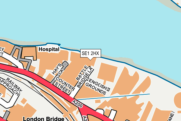
SE1 2HX is located in the London Bridge & West Bermondsey electoral ward, within the London borough of Southwark and the English Parliamentary constituency of Bermondsey and Old Southwark. The Sub Integrated Care Board (ICB) Location is NHS South East London ICB - 72Q and the police force is Metropolitan Police. This postcode has been in use since June 1998.


GetTheData
Source: OS OpenMap – Local (Ordnance Survey)
Source: OS VectorMap District (Ordnance Survey)
Licence: Open Government Licence (requires attribution)
| Easting | 533146 |
| Northing | 180311 |
| Latitude | 51.506054 |
| Longitude | -0.082936 |
GetTheData
Source: Open Postcode Geo
Licence: Open Government Licence
| Country | England |
| Postcode District | SE1 |
| ➜ SE1 open data dashboard ➜ See where SE1 is on a map | |
GetTheData
Source: Land Registry Price Paid Data
Licence: Open Government Licence
Elevation or altitude of SE1 2HX as distance above sea level:
| Metres | Feet | |
|---|---|---|
| Elevation | 10m | 33ft |
Elevation is measured from the approximate centre of the postcode, to the nearest point on an OS contour line from OS Terrain 50, which has contour spacing of ten vertical metres.
➜ How high above sea level am I? Find the elevation of your current position using your device's GPS.
GetTheData
Source: Open Postcode Elevation
Licence: Open Government Licence
| Ward | London Bridge & West Bermondsey |
| Constituency | Bermondsey And Old Southwark |
GetTheData
Source: ONS Postcode Database
Licence: Open Government Licence
| January 2024 | Bicycle theft | On or near Braidwood Street | 194m |
| January 2024 | Bicycle theft | On or near Braidwood Street | 194m |
| January 2024 | Other theft | On or near Braidwood Street | 194m |
| ➜ Get more crime data in our Crime section | |||
GetTheData
Source: data.police.uk
Licence: Open Government Licence
| Hays Galleria (Tooley Street) | London Bridge | 129m |
| Abbots Lane | London Bridge | 221m |
| London Bridge Station Tooley Street | London Bridge | 222m |
| London Bridge Station (Duke Street Hill) | London Bridge | 263m |
| London Bridge Bus Station (London Bridge Street) | London Bridge | 271m |
| London Bridge Underground Station | London Bridge | 414m |
| Monument Underground Station | Monument | 558m |
| Tower Hill Underground Station | Tower Hill | 622m |
| Tower Gateway Dlr Station (Minories) | Tower Gateway | 758m |
| Cannon Street Underground Station | Cannon Street | 799m |
| London Bridge Station | 0.2km |
| London Fenchurch Street Station | 0.7km |
| London Cannon Street Station | 0.8km |
GetTheData
Source: NaPTAN
Licence: Open Government Licence
GetTheData
Source: ONS Postcode Database
Licence: Open Government Licence


➜ Get more ratings from the Food Standards Agency
GetTheData
Source: Food Standards Agency
Licence: FSA terms & conditions
| Last Collection | |||
|---|---|---|---|
| Location | Mon-Fri | Sat | Distance |
| 61 Tooley Street | 18:30 | 13:00 | 141m |
| Tooley Street | 18:30 | 142m | |
| 159 Tooley Street | 18:30 | 13:00 | 331m |
GetTheData
Source: Dracos
Licence: Creative Commons Attribution-ShareAlike
| Facility | Distance |
|---|---|
| Fitness First (London Bridge Cottons) Cottons Building, Tooley Street, London Swimming Pool, Health and Fitness Gym, Studio, Squash Courts | 135m |
| Third Space Health Club (Tower Bridge) More London Riverside, London Health and Fitness Gym, Swimming Pool, Studio | 210m |
| Livingwell Express Club (London Tower Bridge) (Closed) More London Riverside, London Health and Fitness Gym | 269m |
GetTheData
Source: Active Places
Licence: Open Government Licence
| School | Phase of Education | Distance |
|---|---|---|
| Snowsfields Primary School Kirby Grove, London, SE1 3TD | Primary | 510m |
| Tower Bridge Primary School Fair Street, London, SE1 2AE | Primary | 645m |
| Beormund Primary School Crosby Row, Long Lane, London, SE1 3PS | Not applicable | 704m |
GetTheData
Source: Edubase
Licence: Open Government Licence
| Risk of SE1 2HX flooding from rivers and sea | Very Low |
| ➜ SE1 2HX flood map | |
GetTheData
Source: Open Flood Risk by Postcode
Licence: Open Government Licence
The below table lists the International Territorial Level (ITL) codes (formerly Nomenclature of Territorial Units for Statistics (NUTS) codes) and Local Administrative Units (LAU) codes for SE1 2HX:
| ITL 1 Code | Name |
|---|---|
| TLI | London |
| ITL 2 Code | Name |
| TLI4 | Inner London - East |
| ITL 3 Code | Name |
| TLI44 | Lewisham and Southwark |
| LAU 1 Code | Name |
| E09000028 | Southwark |
GetTheData
Source: ONS Postcode Directory
Licence: Open Government Licence
The below table lists the Census Output Area (OA), Lower Layer Super Output Area (LSOA), and Middle Layer Super Output Area (MSOA) for SE1 2HX:
| Code | Name | |
|---|---|---|
| OA | E00020255 | |
| LSOA | E01004027 | Southwark 003E |
| MSOA | E02000809 | Southwark 003 |
GetTheData
Source: ONS Postcode Directory
Licence: Open Government Licence
| SE1 2HD | Counter Street | 45m |
| SE1 2AT | Tooley Street | 184m |
| SE1 2TH | Tooley Street | 203m |
| SE1 2RT | More London Riverside | 222m |
| SE1 2FB | Oxford Drive | 226m |
| SE1 2RU | Magdalen Street | 255m |
| SE1 2TU | Tooley Street | 268m |
| SE1 2RH | Magdalen Street | 273m |
| SE1 2EL | Holyrood Street | 298m |
| SE1 2EN | Magdalen Street | 299m |
GetTheData
Source: Open Postcode Geo; Land Registry Price Paid Data
Licence: Open Government Licence