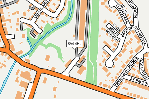
SA4 4HL is located in the Llwchwr electoral ward, within the unitary authority of Swansea and the Welsh Parliamentary constituency of Gower. The Local Health Board is Swansea Bay University and the police force is South Wales. This postcode has been in use since June 1999.


GetTheData
Source: OS OpenMap – Local (Ordnance Survey)
Source: OS VectorMap District (Ordnance Survey)
Licence: Open Government Licence (requires attribution)
| Easting | 259353 |
| Northing | 197844 |
| Latitude | 51.661732 |
| Longitude | -4.034903 |
GetTheData
Source: Open Postcode Geo
Licence: Open Government Licence
| Country | Wales |
| Postcode District | SA4 |
| ➜ SA4 open data dashboard ➜ See where SA4 is on a map ➜ Where is Gorseinon? | |
GetTheData
Source: Land Registry Price Paid Data
Licence: Open Government Licence
Elevation or altitude of SA4 4HL as distance above sea level:
| Metres | Feet | |
|---|---|---|
| Elevation | 10m | 33ft |
Elevation is measured from the approximate centre of the postcode, to the nearest point on an OS contour line from OS Terrain 50, which has contour spacing of ten vertical metres.
➜ How high above sea level am I? Find the elevation of your current position using your device's GPS.
GetTheData
Source: Open Postcode Elevation
Licence: Open Government Licence
| Ward | Llwchwr |
| Constituency | Gower |
GetTheData
Source: ONS Postcode Database
Licence: Open Government Licence
| June 2022 | Anti-social behaviour | On or near Clos Llandyfan | 196m |
| June 2022 | Violence and sexual offences | On or near Glanrhyd Terrace | 283m |
| June 2022 | Violence and sexual offences | On or near Glanrhyd Terrace | 283m |
| ➜ Get more crime data in our Crime section | |||
GetTheData
Source: data.police.uk
Licence: Open Government Licence
| Garden Village Football Club (Swansea Road) | Kingsbridge | 168m |
| Garden Village Football Club (Swansea Road) | Kingsbridge | 181m |
| Tafarn-y-trap (Victoria Road) | Kingsbridge | 274m |
| Tafarn-y-trap (Victoria Road) | Kingsbridge | 314m |
| Glanrhyd Terrace (West Street) | Kingsbridge | 315m |
| Gowerton Station | 1.4km |
| Llangennech Station | 4.5km |
| Bynea Station | 4.6km |
GetTheData
Source: NaPTAN
Licence: Open Government Licence
GetTheData
Source: ONS Postcode Database
Licence: Open Government Licence


➜ Get more ratings from the Food Standards Agency
GetTheData
Source: Food Standards Agency
Licence: FSA terms & conditions
| Last Collection | |||
|---|---|---|---|
| Location | Mon-Fri | Sat | Distance |
| Kingsbridge P O | 17:45 | 12:30 | 412m |
| Garden Village P.o. | 17:45 | 12:30 | 423m |
| West Street | 17:45 | 12:30 | 707m |
GetTheData
Source: Dracos
Licence: Creative Commons Attribution-ShareAlike
| School | Phase of Education | Distance |
|---|---|---|
| Ysgol Gynradd Gymraeg Pontybrenin Loughor Road, Gorseinon, Swansea, SA4 6AU | Not applicable | 632m |
| Pontybrenin Primary School Glyn Rhosyn, Gorseinon, Swansea, SA4 6HX | Not applicable | 632m |
| Penyrheol Comprehensive School Pontarddulais Road, Gorseinon, Swansea, SA4 4FG | Not applicable | 1.5km |
GetTheData
Source: Edubase
Licence: Open Government Licence
The below table lists the International Territorial Level (ITL) codes (formerly Nomenclature of Territorial Units for Statistics (NUTS) codes) and Local Administrative Units (LAU) codes for SA4 4HL:
| ITL 1 Code | Name |
|---|---|
| TLL | Wales |
| ITL 2 Code | Name |
| TLL1 | West Wales and The Valleys |
| ITL 3 Code | Name |
| TLL18 | Swansea |
| LAU 1 Code | Name |
| W06000011 | Swansea |
GetTheData
Source: ONS Postcode Directory
Licence: Open Government Licence
The below table lists the Census Output Area (OA), Lower Layer Super Output Area (LSOA), and Middle Layer Super Output Area (MSOA) for SA4 4HL:
| Code | Name | |
|---|---|---|
| OA | W00010238 | |
| LSOA | W01000773 | Swansea 005A |
| MSOA | W02000172 | Swansea 005 |
GetTheData
Source: ONS Postcode Directory
Licence: Open Government Licence
| SA4 4EA | Clos Y Maerdy | 117m |
| SA4 4HG | Clos Melin Mynach | 142m |
| SA4 4EB | Ffordd Bryngwyn | 169m |
| SA4 4EX | Bryngwyn Avenue | 203m |
| SA4 4QF | Moorland Green | 218m |
| SA4 4JQ | Clos Llandyfan | 219m |
| SA4 4QD | Six Mills Avenue | 222m |
| SA4 4QS | Six Mills Avenue | 250m |
| SA4 4EU | Oak Street | 282m |
| SA4 4QG | Glan Yr Afon | 304m |
GetTheData
Source: Open Postcode Geo; Land Registry Price Paid Data
Licence: Open Government Licence