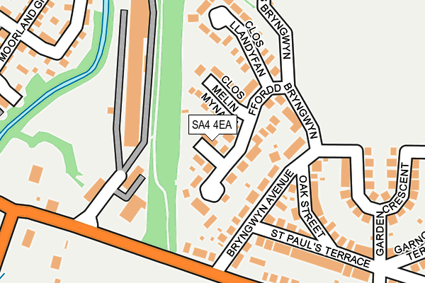
SA4 4EA lies on Clos Y Maerdy in Garden Village, Swansea. SA4 4EA is located in the Llwchwr electoral ward, within the unitary authority of Swansea and the Welsh Parliamentary constituency of Gower. The Local Health Board is Swansea Bay University and the police force is South Wales. This postcode has been in use since January 1993.


GetTheData
Source: OS OpenMap – Local (Ordnance Survey)
Source: OS VectorMap District (Ordnance Survey)
Licence: Open Government Licence (requires attribution)
| Easting | 259467 |
| Northing | 197817 |
| Latitude | 51.661513 |
| Longitude | -4.033226 |
GetTheData
Source: Open Postcode Geo
Licence: Open Government Licence
| Street | Clos Y Maerdy |
| Locality | Garden Village |
| Town/City | Swansea |
| Country | Wales |
| Postcode District | SA4 |
➜ See where SA4 is on a map ➜ Where is Gorseinon? | |
GetTheData
Source: Land Registry Price Paid Data
Licence: Open Government Licence
Elevation or altitude of SA4 4EA as distance above sea level:
| Metres | Feet | |
|---|---|---|
| Elevation | 20m | 66ft |
Elevation is measured from the approximate centre of the postcode, to the nearest point on an OS contour line from OS Terrain 50, which has contour spacing of ten vertical metres.
➜ How high above sea level am I? Find the elevation of your current position using your device's GPS.
GetTheData
Source: Open Postcode Elevation
Licence: Open Government Licence
| Ward | Llwchwr |
| Constituency | Gower |
GetTheData
Source: ONS Postcode Database
Licence: Open Government Licence
1, CLOS Y MAERDY, GARDEN VILLAGE, SWANSEA, SA4 4EA 1995 21 JUL £48,500 |
GetTheData
Source: HM Land Registry Price Paid Data
Licence: Contains HM Land Registry data © Crown copyright and database right 2025. This data is licensed under the Open Government Licence v3.0.
| Garden Village Football Club (Swansea Road) | Kingsbridge | 237m |
| Garden Village Football Club (Swansea Road) | Kingsbridge | 254m |
| Post Office (Swansea Road) | Garden Village | 281m |
| Post Office (Swansea Road) | Garden Village | 317m |
| Tafarn-y-trap (Victoria Road) | Kingsbridge | 351m |
| Gowerton Station | 1.4km |
| Llangennech Station | 4.6km |
| Bynea Station | 4.7km |
GetTheData
Source: NaPTAN
Licence: Open Government Licence
| Percentage of properties with Next Generation Access | 100.0% |
| Percentage of properties with Superfast Broadband | 100.0% |
| Percentage of properties with Ultrafast Broadband | 100.0% |
| Percentage of properties with Full Fibre Broadband | 0.0% |
Superfast Broadband is between 30Mbps and 300Mbps
Ultrafast Broadband is > 300Mbps
| Median download speed | 60.0Mbps |
| Average download speed | 99.3Mbps |
| Maximum download speed | 350.00Mbps |
| Median upload speed | 0.7Mbps |
| Average upload speed | 0.7Mbps |
| Maximum upload speed | 0.78Mbps |
| Percentage of properties unable to receive 2Mbps | 0.0% |
| Percentage of properties unable to receive 5Mbps | 0.0% |
| Percentage of properties unable to receive 10Mbps | 0.0% |
| Percentage of properties unable to receive 30Mbps | 0.0% |
GetTheData
Source: Ofcom
Licence: Ofcom Terms of Use (requires attribution)
GetTheData
Source: ONS Postcode Database
Licence: Open Government Licence


➜ Get more ratings from the Food Standards Agency
GetTheData
Source: Food Standards Agency
Licence: FSA terms & conditions
| Last Collection | |||
|---|---|---|---|
| Location | Mon-Fri | Sat | Distance |
| Garden Village P.o. | 17:45 | 12:30 | 322m |
| Kingsbridge P O | 17:45 | 12:30 | 526m |
| Trinity Street | 17:45 | 12:45 | 798m |
GetTheData
Source: Dracos
Licence: Creative Commons Attribution-ShareAlike
The below table lists the International Territorial Level (ITL) codes (formerly Nomenclature of Territorial Units for Statistics (NUTS) codes) and Local Administrative Units (LAU) codes for SA4 4EA:
| ITL 1 Code | Name |
|---|---|
| TLL | Wales |
| ITL 2 Code | Name |
| TLL1 | West Wales and The Valleys |
| ITL 3 Code | Name |
| TLL18 | Swansea |
| LAU 1 Code | Name |
| W06000011 | Swansea |
GetTheData
Source: ONS Postcode Directory
Licence: Open Government Licence
The below table lists the Census Output Area (OA), Lower Layer Super Output Area (LSOA), and Middle Layer Super Output Area (MSOA) for SA4 4EA:
| Code | Name | |
|---|---|---|
| OA | W00004206 | |
| LSOA | W01000786 | Swansea 007C |
| MSOA | W02000174 | Swansea 007 |
GetTheData
Source: ONS Postcode Directory
Licence: Open Government Licence
| SA4 4EB | Ffordd Bryngwyn | 54m |
| SA4 4HG | Clos Melin Mynach | 89m |
| SA4 4EX | Bryngwyn Avenue | 93m |
| SA4 4EU | Oak Street | 168m |
| SA4 4JQ | Clos Llandyfan | 189m |
| SA4 4EY | St Pauls Terrace | 218m |
| SA4 4ER | Garden Crescent | 228m |
| SA4 4BJ | Clos Bryngwyn | 274m |
| SA4 4HQ | Swansea Road | 286m |
| SA4 4QD | Six Mills Avenue | 309m |
GetTheData
Source: Open Postcode Geo; Land Registry Price Paid Data
Licence: Open Government Licence