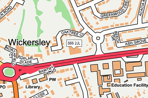
S66 2JL is located in the Wickersley North electoral ward, within the metropolitan district of Rotherham and the English Parliamentary constituency of Wentworth and Dearne. The Sub Integrated Care Board (ICB) Location is NHS South Yorkshire ICB - 03L and the police force is South Yorkshire. This postcode has been in use since June 1997.


GetTheData
Source: OS OpenMap – Local (Ordnance Survey)
Source: OS VectorMap District (Ordnance Survey)
Licence: Open Government Licence (requires attribution)
| Easting | 448156 |
| Northing | 391989 |
| Latitude | 53.422507 |
| Longitude | -1.276824 |
GetTheData
Source: Open Postcode Geo
Licence: Open Government Licence
| Country | England |
| Postcode District | S66 |
| ➜ S66 open data dashboard ➜ See where S66 is on a map ➜ Where is Wickersley? | |
GetTheData
Source: Land Registry Price Paid Data
Licence: Open Government Licence
Elevation or altitude of S66 2JL as distance above sea level:
| Metres | Feet | |
|---|---|---|
| Elevation | 140m | 459ft |
Elevation is measured from the approximate centre of the postcode, to the nearest point on an OS contour line from OS Terrain 50, which has contour spacing of ten vertical metres.
➜ How high above sea level am I? Find the elevation of your current position using your device's GPS.
GetTheData
Source: Open Postcode Elevation
Licence: Open Government Licence
| Ward | Wickersley North |
| Constituency | Wentworth And Dearne |
GetTheData
Source: ONS Postcode Database
Licence: Open Government Licence
| October 2023 | Violence and sexual offences | On or near Larch Avenue | 484m |
| October 2023 | Violence and sexual offences | On or near Larch Avenue | 484m |
| September 2023 | Anti-social behaviour | On or near Larch Avenue | 484m |
| ➜ Get more crime data in our Crime section | |||
GetTheData
Source: data.police.uk
Licence: Open Government Licence
| Plane Drive (Bawtry Road) | Wickersley | 147m |
| Northfield Lane (Bawtry Road) | Wickersley | 181m |
| Morthen Road (Bawtry Road) | Wickersley | 184m |
| Plane Drive (Bawtry Road) | Wickersley | 218m |
| Moss Close (Morthen Road) | Wickersley | 308m |
GetTheData
Source: NaPTAN
Licence: Open Government Licence
GetTheData
Source: ONS Postcode Database
Licence: Open Government Licence


➜ Get more ratings from the Food Standards Agency
GetTheData
Source: Food Standards Agency
Licence: FSA terms & conditions
| Last Collection | |||
|---|---|---|---|
| Location | Mon-Fri | Sat | Distance |
| 40 Goose Lane | 16:00 | 11:00 | 319m |
| Spruce Avenue | 16:15 | 11:30 | 319m |
| 14 Laurel Avenue | 16:15 | 11:30 | 497m |
GetTheData
Source: Dracos
Licence: Creative Commons Attribution-ShareAlike
| Facility | Distance |
|---|---|
| Wickersley School And Sports College Bawtry Road, Wickersley, Rotherham Sports Hall, Grass Pitches, Artificial Grass Pitch, Outdoor Tennis Courts | 230m |
| Wickersley St Albans Ce Primary School Morthen Road, Wickersley, Rotherham Grass Pitches | 373m |
| Wickersley Northfield Primary School Northfield Lane, Wickersley, Rotherham Grass Pitches | 498m |
GetTheData
Source: Active Places
Licence: Open Government Licence
| School | Phase of Education | Distance |
|---|---|---|
| Wickersley School and Sports College Bawtry Road, Wickersley, Rotherham, S66 1JL | Secondary | 187m |
| St Alban's CofE (Aided) Primary School Morthen Road, Wickersley, Rotherham, S66 1EU | Primary | 365m |
| Wickersley Northfield Primary School Northfield Lane, Wickersley, Rotherham, S66 2HL | Primary | 494m |
GetTheData
Source: Edubase
Licence: Open Government Licence
The below table lists the International Territorial Level (ITL) codes (formerly Nomenclature of Territorial Units for Statistics (NUTS) codes) and Local Administrative Units (LAU) codes for S66 2JL:
| ITL 1 Code | Name |
|---|---|
| TLE | Yorkshire and The Humber |
| ITL 2 Code | Name |
| TLE3 | South Yorkshire |
| ITL 3 Code | Name |
| TLE31 | Barnsley, Doncaster and Rotherham |
| LAU 1 Code | Name |
| E08000018 | Rotherham |
GetTheData
Source: ONS Postcode Directory
Licence: Open Government Licence
The below table lists the Census Output Area (OA), Lower Layer Super Output Area (LSOA), and Middle Layer Super Output Area (MSOA) for S66 2JL:
| Code | Name | |
|---|---|---|
| OA | E00038944 | |
| LSOA | E01007687 | Rotherham 022B |
| MSOA | E02001599 | Rotherham 022 |
GetTheData
Source: ONS Postcode Directory
Licence: Open Government Licence
| S66 2NY | Oak Tree Close | 72m |
| S66 2LG | Plane Drive | 75m |
| S66 1JG | Bawtry Road | 85m |
| S66 2NP | Sycamore Avenue | 119m |
| S66 1JQ | Farrington Court | 130m |
| S66 1JJ | Bawtry Road | 131m |
| S66 2NW | Sycamore Avenue | 160m |
| S66 2LH | Beech Grove | 165m |
| S66 1JN | Goose Lane | 178m |
| S66 2JQ | Poplar Glade | 191m |
GetTheData
Source: Open Postcode Geo; Land Registry Price Paid Data
Licence: Open Government Licence