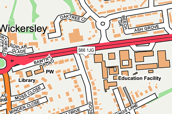
S66 1JG lies on Bawtry Road in Wickersley, Rotherham. S66 1JG is located in the Thurcroft & Wickersley South electoral ward, within the metropolitan district of Rotherham and the English Parliamentary constituency of Rother Valley. The Sub Integrated Care Board (ICB) Location is NHS South Yorkshire ICB - 03L and the police force is South Yorkshire. This postcode has been in use since June 1997.


GetTheData
Source: OS OpenMap – Local (Ordnance Survey)
Source: OS VectorMap District (Ordnance Survey)
Licence: Open Government Licence (requires attribution)
| Easting | 448202 |
| Northing | 391918 |
| Latitude | 53.421885 |
| Longitude | -1.276142 |
GetTheData
Source: Open Postcode Geo
Licence: Open Government Licence
| Street | Bawtry Road |
| Locality | Wickersley |
| Town/City | Rotherham |
| Country | England |
| Postcode District | S66 |
➜ See where S66 is on a map ➜ Where is Wickersley? | |
GetTheData
Source: Land Registry Price Paid Data
Licence: Open Government Licence
Elevation or altitude of S66 1JG as distance above sea level:
| Metres | Feet | |
|---|---|---|
| Elevation | 140m | 459ft |
Elevation is measured from the approximate centre of the postcode, to the nearest point on an OS contour line from OS Terrain 50, which has contour spacing of ten vertical metres.
➜ How high above sea level am I? Find the elevation of your current position using your device's GPS.
GetTheData
Source: Open Postcode Elevation
Licence: Open Government Licence
| Ward | Thurcroft & Wickersley South |
| Constituency | Rother Valley |
GetTheData
Source: ONS Postcode Database
Licence: Open Government Licence
| Plane Drive (Bawtry Road) | Wickersley | 114m |
| Plane Drive (Bawtry Road) | Wickersley | 171m |
| Morthen Road (Bawtry Road) | Wickersley | 207m |
| Northfield Lane (Bawtry Road) | Wickersley | 216m |
| Moss Close (Morthen Road) | Wickersley | 305m |
GetTheData
Source: NaPTAN
Licence: Open Government Licence
| Percentage of properties with Next Generation Access | 100.0% |
| Percentage of properties with Superfast Broadband | 100.0% |
| Percentage of properties with Ultrafast Broadband | 0.0% |
| Percentage of properties with Full Fibre Broadband | 0.0% |
Superfast Broadband is between 30Mbps and 300Mbps
Ultrafast Broadband is > 300Mbps
| Percentage of properties unable to receive 2Mbps | 0.0% |
| Percentage of properties unable to receive 5Mbps | 0.0% |
| Percentage of properties unable to receive 10Mbps | 0.0% |
| Percentage of properties unable to receive 30Mbps | 0.0% |
GetTheData
Source: Ofcom
Licence: Ofcom Terms of Use (requires attribution)
GetTheData
Source: ONS Postcode Database
Licence: Open Government Licence


➜ Get more ratings from the Food Standards Agency
GetTheData
Source: Food Standards Agency
Licence: FSA terms & conditions
| Last Collection | |||
|---|---|---|---|
| Location | Mon-Fri | Sat | Distance |
| 40 Goose Lane | 16:00 | 11:00 | 242m |
| Spruce Avenue | 16:15 | 11:30 | 403m |
| 14 Laurel Avenue | 16:15 | 11:30 | 506m |
GetTheData
Source: Dracos
Licence: Creative Commons Attribution-ShareAlike
The below table lists the International Territorial Level (ITL) codes (formerly Nomenclature of Territorial Units for Statistics (NUTS) codes) and Local Administrative Units (LAU) codes for S66 1JG:
| ITL 1 Code | Name |
|---|---|
| TLE | Yorkshire and The Humber |
| ITL 2 Code | Name |
| TLE3 | South Yorkshire |
| ITL 3 Code | Name |
| TLE31 | Barnsley, Doncaster and Rotherham |
| LAU 1 Code | Name |
| E08000018 | Rotherham |
GetTheData
Source: ONS Postcode Directory
Licence: Open Government Licence
The below table lists the Census Output Area (OA), Lower Layer Super Output Area (LSOA), and Middle Layer Super Output Area (MSOA) for S66 1JG:
| Code | Name | |
|---|---|---|
| OA | E00038952 | |
| LSOA | E01007687 | Rotherham 022B |
| MSOA | E02001599 | Rotherham 022 |
GetTheData
Source: ONS Postcode Directory
Licence: Open Government Licence
| S66 2LG | Plane Drive | 95m |
| S66 1JN | Goose Lane | 97m |
| S66 1JQ | Farrington Court | 99m |
| S66 1JJ | Bawtry Road | 136m |
| S66 2NY | Oak Tree Close | 147m |
| S66 2LH | Beech Grove | 160m |
| S66 2NP | Sycamore Avenue | 177m |
| S66 1JP | Lings Lane | 194m |
| S66 2LQ | Pear Tree Avenue | 222m |
| S66 1ET | Moss Close | 226m |
GetTheData
Source: Open Postcode Geo; Land Registry Price Paid Data
Licence: Open Government Licence